
Dommiers
| Dommiers | ||
|---|---|---|
|
||
| region | Hauts-de-France | |
| Department | Aisne | |
| Arrondissement | Soissons | |
| Canton | Vic-sur-Aisne | |
| Community association | Communauté de communes Retz en Valois | |
| Coordinates | 49 ° 20 ' N , 3 ° 13' E | |
| height | 75-162 m | |
| surface | 7.24 km 2 | |
| Residents | 289 (January 1, 2017) | |
| Population density | 40 inhabitants / km 2 | |
| Post Code | 02600 | |
| INSEE code | 02267 | |
_mairie_-_%C3%A9cole.JPG) Town hall and school building |
||

Dommiers is a commune with 289 inhabitants (as of January 1 2017) in the department of Aisne in the region of Hauts-de-France (former Region: Picardie ). The municipality belongs to the arrondissement of Soissons and is part of the canton of Vic-sur-Aisne . The inhabitants are referred to as Dommarien (ne) s .
geography
The community is located above the Ruisseau de Saint-Pierre-Aigle creek to the west at a distance from the Route nationale 2 , which connects Paris with Soissons , around ten kilometers southwest of Soissons and 13 km northeast of Villers-Cotterêts . It includes the La Glaue and Ferme du Chauffour groups of houses. Neighboring communities are Cutry in the north-west, Saconin-et-Breuil in the north-east, Missy-aux-Bois and Chaudun in the east and Saint-Pierre-Aigle in the south and west.
Population development
| year | 1962 | 1968 | 1975 | 1982 | 1990 | 1999 | 2009 | 2015 |
| Residents | 284 | 260 | 258 | 221 | 252 | 279 | 288 | 289 |
| Source: Cassini and INSEE | ||||||||
Attractions
- The Notre-Dame church, rebuilt after 1918
- War memorial (monument aux morts)
- Several memorial plaques
- Fountain
- Ferme de la Glaue with surrounding wall and pigeon house

Notre-Dame church
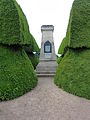
War memorial

Fountain
_%C3%A9glise.JPG)
_monument_aux_morts.JPG)
_fontaine.JPG)