Marizy-Saint-Mard
| Marizy-Saint-Mard | ||
|---|---|---|
|
|
||
| region | Hauts-de-France | |
| Department | Aisne | |
| Arrondissement | Soissons | |
| Canton | Villers-Cotterêts | |
| Community association | Communauté de communes Retz en Valois | |
| Coordinates | 49 ° 11 ' N , 3 ° 14' E | |
| height | 72-155 m | |
| surface | 4.54 km 2 | |
| Residents | 50 (January 1, 2017) | |
| Population density | 11 inhabitants / km 2 | |
| Post Code | 02470 | |
| INSEE code | 02467 | |
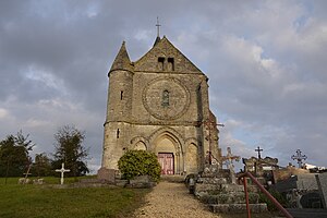
 The Saint-Martin church |
||
Marizy-Saint-Mard is a French commune with a population of 50 (as at 1st January 2017) in the department of Aisne in the region of Hauts-de-France (former Region: Picardie ). The municipality belongs to the arrondissement of Soissons , to which it moved from the arrondissement of Château-Thierry with nine other municipalities in 2017 , and is part of the canton of Villers-Cotterêts .
geography
The community is south of the Ourcq ; the railway Trilport-Bazoches that in Bazoches-sur-Vesles on the route from Soissons to Reims true, touches the municipal area in the north. Neighboring communities are Chouy in the north, Neuilly-Saint-Front in the east, Macogny and Passy-en-Valois in the south and Marizy-Sainte-Geneviève in the west. The community has no named districts.
Population development
| year | 1962 | 1968 | 1975 | 1982 | 1990 | 1999 | 2009 | 2015 |
| Residents | 78 | 90 | 53 | 34 | 49 | 55 | 56 | 49 |
| Source: Cassini and INSEE | ||||||||
Attractions
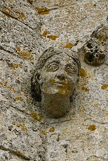
- The church of Saint-Martin , dating back to the 12th century, classified as a Monument historique in 1920 ( Base Mérimée PA00115806).
- The castle ( Château de Marizy-Saint-Mard ) dates back to the fourth quarter of the 13th century, parts were registered as a monument historique in 1928 (gatehouse, remains of the surrounding wall) and classified in 1930 (donjon) ( Base Mérimée PA00115805).


