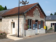
Vuillery
| Vuillery | ||
|---|---|---|
|
|
||
| region | Hauts-de-France | |
| Department | Aisne | |
| Arrondissement | Soissons | |
| Canton | Fère-en-Tardenois | |
| Community association | Communauté de communes du Val de l'Aisne | |
| Coordinates | 49 ° 26 ' N , 3 ° 23' E | |
| height | 61-149 m | |
| surface | 1.09 km 2 | |
| Residents | 43 (January 1, 2017) | |
| Population density | 39 inhabitants / km 2 | |
| Post Code | 02880 | |
| INSEE code | 02829 | |
 Entrance from the direction of Crouy |
||
Vuillery is a commune with 43 inhabitants (as at 1st January 2017) in the department of Aisne in the region of Hauts-de-France (former Region: Picardie ). The municipality belongs to the Arrondissement of Soissons and is part of the canton of Fère-en-Tardenois and the communal association Communauté de communes du Val de l'Aisne . She was awarded the Croix de guerre award from 1914 to 1918.
geography
The municipality, located 8 km north-northeast of Soissons on the D1200 departmental road, is the smallest in the canton in terms of area. The La Plaine – Hirson railway runs through the municipality . Vuillery borders the neighboring municipalities of Terny-Sorny in the north, Margival in the east, Braye in the south and Clamecy in the west.
Population development
| year | 1962 | 1968 | 1975 | 1982 | 1990 | 1999 | 2008 | 2015 |
| Residents | 53 | 30th | 26th | 20th | 31 | 24 | 32 | 44 |
| Source: Cassini and INSEE | ||||||||
Web links
Commons : Vuillery - collection of images, videos and audio files

