
Brenelle
| Brenelle | ||
|---|---|---|
|
||
| region | Hauts-de-France | |
| Department | Aisne | |
| Arrondissement | Soissons | |
| Canton | Fère-en-Tardenois | |
| Community association | Communauté de communes du Val de l'Aisne | |
| Coordinates | 49 ° 22 ′ N , 3 ° 33 ′ E | |
| height | 60-174 m | |
| surface | 4.34 km 2 | |
| Residents | 195 (January 1, 2017) | |
| Population density | 45 inhabitants / km 2 | |
| Post Code | 02220 | |
| INSEE code | 02120 | |
_mairie.JPG) Mairie from Brenelle |
||

Brenelle is a commune with 195 inhabitants (as of January 1 2017) in the department of Aisne in the region of Hauts-de-France (former Region: Picardie ). The municipality belongs to the arrondissement of Soissons and is part of the canton of Fère-en-Tardenois . The inhabitants are known as Brenellois (es) . The municipality carries the Croix de guerre 1914-1918.
geography
The municipality with the district La Cormorande is located north of Braine on the D1320 département road around 17 km east of Soissons . Neighboring municipalities are Presles-et-Boves and Cys-la-Commune in the north, Courcelles-sur-Vesle in the east, Braine in the south and Chassemy in the west.
history
The community, known as Branella in 1147, was the scene of heavy fighting in the First World War in May 1918 during the Battle of the Aisne .
Population development
| year | 1962 | 1968 | 1975 | 1982 | 1990 | 1999 | 2010 | 2015 |
| Residents | 164 | 204 | 168 | 189 | 184 | 190 | 199 | 197 |
| Source: Cassini and INSEE | ||||||||
Attractions
- Saint-Pierre church from the 12th to 16th centuries, classified as a Monument historique in 1921 ( Base Mérimée PA00115556).
- Crucifixion Group (Calvaire).
- War memorial (Monument aux morts).

Saint-Pierre church
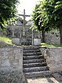
Calvaire
_%C3%A9glise_(01).JPG)
_calvaire.JPG)