
Bucy-le-Long
| Bucy-le-Long | ||
|---|---|---|

|
|
|
| region | Hauts-de-France | |
| Department | Aisne | |
| Arrondissement | Soissons | |
| Canton | Fère-en-Tardenois | |
| Community association | Val de l'Aisne | |
| Coordinates | 49 ° 23 ' N , 3 ° 24' E | |
| height | 39-161 m | |
| surface | 12.86 km 2 | |
| Residents | 1,880 (January 1, 2017) | |
| Population density | 146 inhabitants / km 2 | |
| Post Code | 02880 | |
| INSEE code | 02131 | |
| Website | http://www.bucy-le-long.fr/ | |

Bucy-le-Long is a French commune with 1,880 inhabitants (as of January 1 2017) in the department of Aisne in the region of Hauts-de-France ; it belongs to the arrondissement of Soissons and the canton of Fère-en-Tardenois (until 2015: canton of Vailly-sur-Aisne ).
geography
Bucy-le-Long is about five kilometers east of Soissons . The Aisne River limits the municipality to the south. Bucy-le-Long is surrounded by the neighboring municipalities of Crouy in the north and northwest, Vregny in the northeast, Chivres-Val in the east, Missy-sur-Aisne in the east and southeast, Acy in the south and southeast, Venizel in the south, Villeneuve-Saint- Germain to the west and southwest and Soissons to the west.
The National Route 2 runs through the municipality .
Population development
| year | 1962 | 1968 | 1975 | 1982 | 1990 | 1999 | 2006 | 2012 |
| Residents | 1,214 | 1,387 | 1,661 | 1,801 | 1,841 | 1,958 | 1,964 | 1.926 |
| Source: Cassini and INSEE | ||||||||
Attractions
- Saint-Martin church, monument historique since 1923
- Chapel of Sainte-Marguerite from the 12th century, monument historique since 1920
- Tower of the former castle from the 14th century, a historic monument since 1926
- Archaeological dig site La Fosse Tournise with finds and findings from the Neolithic Age

Saint Martin Church

Chapel of Sainte-Marguerite
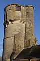
Tower of the former castle
_%C3%89glise.JPG)
.JPG)
