Rozières-sur-Crise
| Rozières-sur-Crise | ||
|---|---|---|
|
|
||
| region | Hauts-de-France | |
| Department | Aisne | |
| Arrondissement | Soissons | |
| Canton | Villers-Cotterêts | |
| Community association | Communauté de communes du Canton d'Oulchy-le-Château | |
| Coordinates | 49 ° 20 ′ N , 3 ° 21 ′ E | |
| height | 57-166 m | |
| surface | 7.32 km 2 | |
| Residents | 227 (January 1, 2017) | |
| Population density | 31 inhabitants / km 2 | |
| Post Code | 02200 | |
| INSEE code | 02663 | |
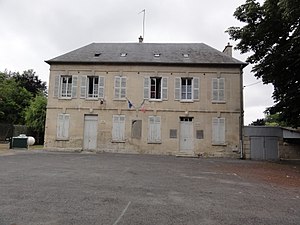
 The Mairie |
||
Rozières-sur-Crise is a municipality with 227 inhabitants (as of January 1 2017) in the department of Aisne in the region of Hauts-de-France (former Region: Picardie ). The municipality belongs to the arrondissement of Soissons and is part of the canton of Villers-Cotterêts .
geography
The community is located on the D831 departmental road with the eponymous district on the left bank of the Crise river , which flows into the Aisne , around six kilometers south-southeast of Soissons. The district of Faubourg d'Écuiry and the castle of Écuiry are on the right bank of the Crise, as is the hamlet of Mesmin. Neighboring communities are Noyant-et-Aconin and Septmonts and Billy-sur-Aisne in the north, Acy and Ambrief in the east, Chacrise in the south and Buzancy in the west.
Population development
| year | 1962 | 1968 | 1975 | 1982 | 1990 | 1999 | 2007 | 2015 |
| Residents | 196 | 166 | 163 | 206 | 271 | 261 | 233 | 232 |
| Source: Cassini and INSEE | ||||||||
Attractions
- The Château d'Écuiry from 1695; the garden is entered in the general inventory (IA02001277).
- The Château de Rozières castle.
- The Saint-Martin church.
- British war graves in the cemetery.


