Saint-Bandry
| Saint-Bandry | ||
|---|---|---|
|
|
||
| region | Hauts-de-France | |
| Department | Aisne | |
| Arrondissement | Soissons | |
| Canton | Vic-sur-Aisne canton | |
| Community association | Retz en Valois | |
| Coordinates | 49 ° 22 ′ N , 3 ° 10 ′ E | |
| height | 49-157 m | |
| surface | 6.02 km 2 | |
| Residents | 267 (January 1, 2017) | |
| Population density | 44 inhabitants / km 2 | |
| Post Code | 02290 | |
| INSEE code | 02672 | |
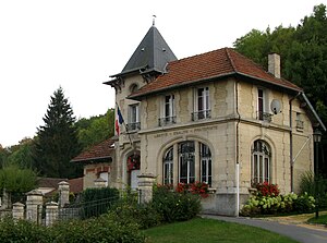
 Town hall (Mairie) of Saint-Bandry |
||
Saint-Bandry is a northern commune with 267 inhabitants (as of January 1 2017) in the department of Aisne in the region of Hauts-de-France . The municipality belongs to the arrondissement of Soissons and the canton of Vic-sur-Aisne .
geography
Saint-Bandry is embedded by the neighboring communities of Ambleny in the west, north and east and Laversine in the south.
Population development
| 1962 | 1968 | 1975 | 1982 | 1990 | 1999 | 2006 | 2015 |
|---|---|---|---|---|---|---|---|
| 221 | 221 | 214 | 200 | 202 | 238 | 234 | 283 |
| Source: Cassini and INSEE | |||||||
Attractions
- Saint-Bandry Church
Web links
Commons : Saint-Bandry - Collection of images, videos and audio files

