Pargny-Filain
| Pargny-Filain | ||
|---|---|---|

|
|
|
| region | Hauts-de-France | |
| Department | Aisne | |
| Arrondissement | Soissons | |
| Canton | Fère-en-Tardenois | |
| Community association | Val de l'Aisne | |
| Coordinates | 49 ° 28 ' N , 3 ° 33' E | |
| height | 62-192 m | |
| surface | 5.01 km 2 | |
| Residents | 259 (January 1, 2017) | |
| Population density | 52 inhabitants / km 2 | |
| Post Code | 02000 | |
| INSEE code | 02589 | |
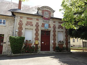
 Pargny-Filain Town Hall (Mairie) |
||
Pargny-Filain is a French municipality with 259 inhabitants (as of January 1 2017) in the department of Aisne in the region of Hauts-de-France . It belongs to the Arrondissement of Soissons , the Canton of Fère-en-Tardenois and the Val de l'Aisne municipal association .
geography
Pargny-Filain, which lies on the Chemin des Dames and the Canal de l'Oise à l'Aisne, is surrounded by the neighboring communities of Monampteuil in the northeast, Filain in the east, Aizy-Jouy in the south, Chavignon in the west and in the canton of Laon- 1 municipality of Urcel in the north.
Population development
| year | 1962 | 1968 | 1975 | 1982 | 1990 | 1999 | 2007 | 2015 |
| Residents | 136 | 133 | 147 | 191 | 195 | 201 | 232 | 250 |
| Source: Cassini and INSEE | ||||||||
Attractions
- Saint-Pierre church
Web links
Commons : Pargny-Filain - collection of images, videos and audio files

