
Sermoise
| Sermoise | ||
|---|---|---|
|
||
| region | Hauts-de-France | |
| Department | Aisne | |
| Arrondissement | Soissons | |
| Canton | Soissons-2 | |
| Community association | Communauté d'agglomération du Soissonnais | |
| Coordinates | 49 ° 22 ′ N , 3 ° 27 ′ E | |
| height | 42-163 m | |
| surface | 5.51 km 2 | |
| Residents | 349 (January 1, 2017) | |
| Population density | 63 inhabitants / km 2 | |
| Post Code | 02220 | |
| INSEE code | 02714 | |
_mairie-%C3%A9cole.JPG) The Mairie-École |
||

Sermoise is a commune with 349 inhabitants (as of January 1 2017) in the department of Aisne in the region of Hauts-de-France (former Region: Picardie ). The municipality belongs to the arrondissement of Soissons and is part of the canton of Soissons-2 .
geography
The national route 31 ( European route 46 ), which connects the Soissons with Reims , about 8 km east of Soissons, extends in the north to the left bank of the Aisne . The municipality is located on the disused and partially dismantled railway line from Soissons to Bazoches-sur-Vesles through the valley of the Vesle. Neighboring communities are Missy-sur-Aisne and Condé-sur-Aisne in the north, Ciry-Salsogne in the east and Acy in the south-west and west, connected by a bridge .
Population development
| year | 1962 | 1968 | 1975 | 1982 | 1990 | 1999 | 2007 | 2015 |
| Residents | 288 | 302 | 289 | 300 | 361 | 341 | 315 | 340 |
| Source: Cassini and INSEE | ||||||||
Attractions
- The Saint-Rémi church.
- The war memorial (Monument aux morts).
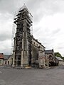
The Saint-Rémi church during restoration in 2015

War memorial
_%C3%A9glise_Saint-R%C3%A9mi_en_restauration,_juin_2015.jpg)
_monument_aux_morts.JPG)