Oigny-en-Valois
| Oigny-en-Valois | ||
|---|---|---|

|
|
|
| region | Hauts-de-France | |
| Department | Aisne | |
| Arrondissement | Soissons | |
| Canton | Villers-Cotterêts | |
| Community association | Communauté de communes Retz en Valois | |
| Coordinates | 49 ° 13 ' N , 3 ° 8' E | |
| height | 72-158 m | |
| surface | 11.88 km 2 | |
| Residents | 155 (January 1, 2017) | |
| Population density | 13 inhabitants / km 2 | |
| Post Code | 02600 | |
| INSEE code | 02568 | |
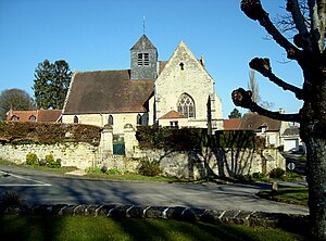
 Saint Martin Church |
||
Oigny-en-Valois is a French municipality with 155 inhabitants (as of January 1 2017) in the department of Aisne in the region of Hauts-de-France (former Region: Picardie ). The municipality belongs to the arrondissement of Soissons and is part of the canton of Villers-Cotterêts . The inhabitants are called Ogniacien (ne) s .
geography
The municipality with the district of Baisemont, located southeast of Villers-Cotterêts and surrounded by the Forêt de Retz domain forest, forms a cleared island. Neighboring communities are Dampleux in the north, Faverolles in the east, Troësnes , Silly-la-Poterie and La Ferté-Milon in the south and Villers-Cotterêts in the west.
Population development
| year | 1962 | 1968 | 1975 | 1982 | 1990 | 1999 | 2009 | 2015 |
| Residents | 119 | 92 | 116 | 137 | 188 | 163 | 146 | 151 |
| Source: Cassini and INSEE | ||||||||
Attractions
- Saint-Martin church from the transition from the 12th to the 13th century
- The castle, built between 1498 and 1515, registered as Monument historique in 1928 ( Base Mérimée PA00115851), with garden, registered in the pre-inventory under IA02001264
- Wayside cross (Croix monumentale) in the new cemetery, Monument historique, registered 1928, Base Mérimée PA00115852
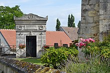
- Mausoleum for General Henri François Marie Charpentier, registered as a Monument historique in 1990, Base Mérimée PA00116003
Web links
Commons : Oigny-en-Valois - Collection of images, videos and audio files


