Faverolles (Aisne)
| Faverolles | ||
|---|---|---|
|
|
||
| region | Hauts-de-France | |
| Department | Aisne | |
| Arrondissement | Soissons | |
| Canton | Villers-Cotterêts | |
| Community association | Communauté de communes Retz en Valois | |
| Coordinates | 49 ° 13 ' N , 3 ° 11' E | |
| height | 67-177 m | |
| surface | 13.79 km 2 | |
| Residents | 317 (January 1, 2017) | |
| Population density | 23 inhabitants / km 2 | |
| Post Code | 02600 | |
| INSEE code | 02302 | |
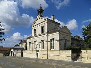
 The Mairie |
||
Faverolles is a French municipality with 317 inhabitants (as of January 1 2017) in the department of Aisne in the region of Hauts-de-France (former Region: Picardie ). The municipality belongs to the arrondissement of Soissons and is part of the canton of Villers-Cotterêts . The place name is derived from the Latin "faba" (bean).
geography
The municipality , located around 8 km east-southeast of Villers-Cotterêts and largely surrounded by the Forêt de Retz domain forest, with the districts of Vouty, Javage, Maucreux, Le Bouchet (the last three in the valley of the Savières river, which borders the municipality in the east and flows into the Ourcq ). Neighboring communities are Corcy in the north, Chouy , Ancienville , Noroy-sur-Ourcq and Troësnes in the east, Silly-la-Poterie in the south and Oigny-en-Valois and Dampleux in the west.
Population development
| year | 1962 | 1968 | 1975 | 1982 | 1990 | 1999 | 2008 | 2015 |
| Residents | 364 | 361 | 283 | 265 | 308 | 319 | 346 | 308 |
| Source: Cassini and INSEE | ||||||||
Attractions
- Maucreux Castle, rebuilt from 1930 to 1935.
- The Maucreux Mill.

