
Soucy (Aisne)
| Soucy | ||
|---|---|---|
|
||
| region | Hauts-de-France | |
| Department | Aisne | |
| Arrondissement | Soissons | |
| Canton | Villers-Cotterêts | |
| Community association | Communauté de communes Retz en Valois | |
| Coordinates | 49 ° 19 ′ N , 3 ° 8 ′ E | |
| height | 65-152 m | |
| surface | 5.22 km 2 | |
| Residents | 97 (January 1, 2017) | |
| Population density | 19 inhabitants / km 2 | |
| Post Code | 02600 | |
| INSEE code | 02729 | |
_mairie.JPG) Mairie |
||

Soucy is a commune with 97 inhabitants (as at 1st January 2017) in the department of Aisne in the region of Hauts-de-France (former Region: Picardie ). The municipality belongs to the arrondissement of Soissons and is part of the canton of Villers-Cotterêts and the community association Communauté de communes Retz en Valois .
geography
The community, located around 10 km north of Villers-Cotterêts , is west of the Ru de Retz on the northern edge of the Forêt de Retz domain forest . Neighboring municipalities are Cœuvres-et-Valsery in the north and east, Montgobert in the southeast, Puiseux-en-Retz in the south and Vivières in the west.
Population development
| year | 1962 | 1968 | 1975 | 1982 | 1990 | 1999 | 2009 | 2015 |
| Residents | 91 | 89 | 72 | 62 | 68 | 73 | 87 | 102 |
| Source: Cassini and INSEE | ||||||||
Attractions
- Saint-Martin church from the 13th century, registered as a monument historique in 1927 .
- Claw stand (travail à ferrer).
- Grangie from the 13th century and part of the surrounding wall of the former Wilhelmite Abbey of Saint-Médard, registered as a Monument historique in 1928.
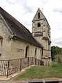
Saint Martin Church
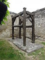
Claw stance
_%C3%A9glise_(02).JPG)
_un_travail_%C3%A0_ferrer.JPG)
Individual evidence
- ^ Church of Saint-Martin in the Base Mérimée of the French Ministry of Culture (French)
- ↑ Grangie in the Base Mérimée of the French Ministry of Culture (French)
Web links
Commons : Soucy - collection of images, videos and audio files