
Terny-Sorny
| Terny-Sorny | ||
|---|---|---|
|
||
| region | Hauts-de-France | |
| Department | Aisne | |
| Arrondissement | Soissons | |
| Canton | Fère-en-Tardenois | |
| Community association | Communauté de communes du Val de l'Aisne | |
| Coordinates | 49 ° 27 ' N , 3 ° 22' E | |
| height | 72-163 m | |
| surface | 7.07 km 2 | |
| Residents | 330 (January 1, 2017) | |
| Population density | 47 inhabitants / km 2 | |
| Post Code | 02880 | |
| INSEE code | 02739 | |
_mairie-%C3%A9cole.JPG) Mairie-École |
||

Terny-Sorny is a commune with 330 inhabitants (as of January 1, 2017) in the department of Aisne in the region of Hauts-de-France (former Region: Picardie ). The municipality belongs to the Arrondissement of Soissons and is part of the canton of Fère-en-Tardenois and the communal association Communauté de communes du Val de l'Aisne . The municipality was awarded the Croix de guerre award from 1914 to 1918.
geography
Located 9 km north of Soissons on the D1 departmental road , the community with the district Sorny borders the neighboring communities Leuilly-sous-Coucy and Vauxaillon in the north, Neuville-sur-Margival and Margival in the east, Vuillery , Clamecy and Leury in the south and Juvigny in the West.
Population development
| year | 1962 | 1968 | 1975 | 1982 | 1990 | 1999 | 2008 | 2015 |
| Residents | 221 | 253 | 244 | 230 | 315 | 328 | 308 | 325 |
| Source: Cassini and INSEE | ||||||||
Attractions
- Church of Sainte-Cécile
- War memorial (Monument aux morts)
- crossroads
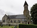
church

War memorial

crossroads
_%C3%A9glise_(01).JPG)
_monument_aux_morts.JPG)
_croix_de_chemin.JPG)
Web links
Commons : Terny-Sorny - collection of images, videos and audio files