
Saconin-et-Breuil
| Saconin-et-Breuil | ||
|---|---|---|

|
|
|
| region | Hauts-de-France | |
| Department | Aisne | |
| Arrondissement | Soissons | |
| Canton | Vic-sur-Aisne | |
| Community association | Communauté de communes Retz en Valois | |
| Coordinates | 49 ° 21 ′ N , 3 ° 15 ′ E | |
| height | 58-161 m | |
| surface | 8.53 km 2 | |
| Residents | 228 (January 1, 2017) | |
| Population density | 27 inhabitants / km 2 | |
| Post Code | 02200 | |
| INSEE code | 02667 | |
_mairie-%C3%A9cole.JPG) Municipal office and school building |
||

Saconin-et-Breuil is a commune with 228 inhabitants (as of January 1 2017) in the department of Aisne in the region of Hauts-de-France (former Region: Picardie ). The municipality belongs to the arrondissement of Soissons and is part of the canton of Vic-sur-Aisne .
geography
The municipality, to which, in addition to the two eponymous villages, the districts of Saint-Amant and Le Mont d'Arly belong, is located on the D94 departmental road about 9 km west-southwest of Soissons . Neighboring communities are Mercin-et-Vaux in the north in the Aisne valley , Vauxbuin and Courmelles in the east, Missy-aux-Bois in the south, Dommiers in the southwest and Pernant in the west.
Population development
| year | 1962 | 1968 | 1975 | 1982 | 1990 | 1999 | 2009 | 2015 |
| Residents | 188 | 194 | 205 | 211 | 233 | 234 | 226 | 238 |
| Source: Cassini and INSEE | ||||||||
Attractions
- The church of Saint-Gervais-et-Saint-Protais from the 12th and 13th centuries, classified as a Monument historique in 1921 ( Base Mérimée PA00115895).
- War memorial (monument aux morts)
- Several wayside crosses
- Community wash house

Saint-Gervais-et-Saint-Protais church

War memorial
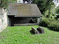
Community wash house
_%C3%A9glise.JPG)
_monument_aux_morts.JPG)
_lavoir_communal.JPG)
Web links
Commons : Saconin-et-Breuil - Collection of Images, Videos and Audio Files