
Brand-Erbisdorf
| coat of arms | Germany map | |
|---|---|---|

|
Coordinates: 50 ° 52 ′ N , 13 ° 19 ′ E |
|
| Basic data | ||
| State : | Saxony | |
| County : | Central Saxony | |
| Height : | 460 m above sea level NHN | |
| Area : | 46.33 km 2 | |
| Residents: | 9337 (Dec. 31, 2019) | |
| Population density : | 202 inhabitants per km 2 | |
| Postal code : | 09618 | |
| Primaries : | 037322, 037329 | |
| License plate : | FG, BED, DL, FLÖ, HC, MW, RL | |
| Community key : | 14 5 22 050 | |
| City structure: | Main area and 6 districts | |
City administration address : |
Markt 1 09618 Brand-Erbisdorf |
|
| Website : | ||
| Lord Mayor : | Martin Antonov (independent) | |
| Location of the city of Brand-Erbisdorf in the district of central Saxony | ||
  |
||

The large district town of Brand-Erbisdorf is a mountain town in the district of Central Saxony in Saxony .
geography
Brand-Erbisdorf is located in the north-western part of the Osterzgebirge between the valleys of the Münzbach and the Great Striegis , both tributaries of the Freiberg Mulde , about 5 km south of the district town of Freiberg . The area is characterized by mining and former mining facilities such as spoil heaps and artificial ponds . The city center is around 473 m above sea level. NN , the lowest point is in the valley of the Great Striegis at around 390 m and the highest point at 591 m above sea level. NN south of Langenau. The city borders in the north on Freiberg, in the east on Weißenborn , in the south-east on Lichtenberg , in the south on Großhartmannsdorf , in the south-west on Eppendorf and in the west on Oederan .
City structure
The city is structured as follows:
Brand-Erbisdorf main area
- the formerly independent mountain town of Brand in the north (area: 1.31 km²)
- the formerly independent community of Erbisdorf in the south with the community parts Mönchenfrei , Niederfrei and Zugspitze (area: 10.54 km²)
Two localities according to the Saxon municipal code , with the districts
- St. Michaelis with Linda and Himmelsfürst
- Langenau with Gränitz and Oberreichenbach
history


The first mention of the village Erbisdorf as Erlwinesberc dates from the year 1209. It can be assumed that the village emerged in the course of clearing and settlement in the middle of the 12th century. The name after the personal name Erlwin probably comes from the Harz mining area.
In the first half of the 13th century silver mining began in Erbisdorf , which is part of the Freiberg mining area as a Brander mine field . A scattered mining settlement was built on the neighboring mountain Brand , which Duke George the Bearded elevated to a mountain spot in 1515. Brand received market rights in 1620 and town rights in 1834 . Until 1856, Brand and Erbisdorf were part of the Freiberg district office in Electoral Saxony or in the royal Saxon district . In 1856 the town of Brand became the seat of the Brand Judicial Office , to which Erbisdorf also belonged. From 1875, both places were under the Freiberg administration . With the opening of the Berthelsdorf – Großhartmannsdorf and Brand – Langenau railway lines in 1890, both places received a rail connection.
At the beginning of the 20th century, the long tradition of silver mining around Brand ended, where a quarter of Saxony's total silver was extracted. Mining was only revived to a lesser extent after 1945, but it was finally shut down around 1968. After 1900, instead of mining, industrial companies were increasingly established, of which the Erzgebirge wood industry and the elite factories were the best known.
On April 1, 1912, Brand and Erbisdorf were forced to unite, as the councils were unable to come to an agreement on a voluntary merger after years of negotiations. The main reason for this was the economic development, because the city corridors of Brand, which practically only comprised the urban development, were bordered by Erbisdorf in the south and east.
In 1952 Brand-Erbisdorf became the district town of the Brand-Erbisdorf district in the Chemnitz district (renamed the Karl-Marx-Stadt district in 1953 ). This status was lost in 1994 when the now Saxon district of Brand-Erbisdorf was dissolved and assigned to the district of Freiberg . Since then the city has been a major district town . It has about 10,000 inhabitants. On October 1, 1993, St. Michaelis was incorporated with its districts Himmelsfürst and Linda. The community of Langenau with its districts Gränitz and Oberreichenbach was incorporated on April 1, 2002. Brand-Erbisdorf has been part of the Central Saxony district since 2008.

Memorials
- Memorial stone "In memory of the victims of all tyranny" at the Sonnenwirbelhalde
- Graves in the local cemetery on Kirchweg for anti-fascist resistance fighters
Incorporations
| Former parish | date | annotation |
|---|---|---|
| fire | April 1, 1912 | Merger with Erbisdorf to Brand-Erbisdorf |
| Erbisdorf | April 1, 1912 | Merger with Brand to Brand-Erbisdorf |
| Gränitz | 15th January 1970 | Incorporation to Langenau |
| Gränitz, manor district | around 1922 | Incorporation to Gränitz |
| Langenau | April 1, 2002 | |
| Linda | July 1, 1950 | Incorporation to St. Michaelis |
| Linda, manor | around 1922 | Incorporation after Linda |
| Niederfrei with Mönchenfrei, manor district (forest district) | October 13, 1948 | |
| Niederlangenau | July 1, 1905 | Merger with Oberlangenau to Langenau |
| Niederlangenau, manor district | around 1922 | Incorporation to Langenau |
| Oberlangenau | July 1, 1905 | Merger with Niederlangenau to Langenau |
| Oberlangenau, manor district | around 1922 | Incorporation to Langenau |
| Oberreichenbach | January 1, 1993 | Incorporation to Langenau |
| St. Michaelis | October 1, 1993 | Incorporation to Brand-Erbisdorf |
Population development
The following population figures refer to December 31 of the respective year, territorial status 2010:
|
1982 to 1989
|
1990 to 1997
|
1998 to 2005
|
2006 to 2014
|
2015 and 2016
|
Source: State Statistical Office of the Free State of Saxony
politics
City council
From the main statute: The city council represents the citizens of the large district town of Brand-Erbisdorf and is the main organ of the city. The city council decides on all matters which are assigned to it by law and which do not belong to the mayor's area of responsibility. The city council monitors the implementation of its resolutions and ensures that irregularities in the city administration are remedied.
The city council consists of 22 city councilors and the non-party mayor.
Since the city council election on May 26, 2019 , the 22 seats of the city council have been distributed among the individual groups as follows:
| Party / group | Seats |
|---|---|
| CDU | 10 |
| Free voters | 6th |
| left | 3 |
| Citizens for BED (BFBED) | 3 |
Lord Mayor
On February 4, 2007, the deputy director of the Chemnitz Natural History Museum, Martin Antonow, was elected mayor with 51.0% of the vote. He succeeded Volker Zweig on February 27th.
Town twinning
- Dillingen on the Danube , Bavaria
- Jirkov (Görkau) , Czech Republic
- Langenau , Baden-Wuerttemberg
Since November 1, 2004, the city has been a member of the Erzgebirge Regional Management, a regional initiative of the Erzgebirgskreis and ten other municipalities in the Erzgebirge .
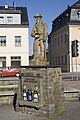
Attractions
- Evangelical Lutheran City Church : The core of the church dates from around 1300. The west tower was built in 1598. The parish church was renovated in the Gothic style in 1624 after a fire . Further internal and external redesigns were carried out in 1836 (hall, tower) and 1930 (choir). The church houses, among other things, a life-size miner's figure made in 1585 and an Oehme organ from 1774.
- "Bartholomäusschacht": The mining exhibition system shows early modern mining and conveying technology.
- Museum "Huthaus Einigkeit": In the "Huthaus Einigkeit" there is the city museum, which provides information about the city and mining history of Brand-Erbisdorf.
- Buttermilk Gate: The Buttermilk Gate, built in 1821, was part of an artificial moat system .
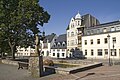
center
Center, detail

Buttermilk Gate

town hall
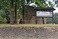
Bartholomäusschacht

church
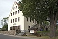
Museum "Huthaus Unity"


Economy and Infrastructure

The city is developing tourism , the Silver Road runs through it . To the east of the city on the edge of the Freiwald lies the Erzengler pond , which serves as an outdoor pool.
Also:
- since 1914 the Elite Motorenwerke , later Opel or VEB and now industrial park
- until 1994 the " Hansa-Keks " was produced in Brand-Erbisdorf
- NARVA - lamp manufacture, press and forge shop,
- East German branch of the Unglehrt construction company
traffic
The federal highway 101 runs through the city , via which one reaches Freiberg (5 km) in the north and Annaberg-Buchholz (about 50 km) in the south. Dresden (41 km) can be reached via Freiberg ( B 173 ) and Chemnitz via Oberschöna ( B 173 ). The city can be reached in about half an hour via the Bundesautobahn 4 , exit Siebenlehn .
Brand-Erbisdorf has a freight yard on the branch line from Berthelsdorf . The route opened in 1890 continued to Großhartmannsdorf until 1973 . The railway line to Langenau that branches off at Brand-Erbisdorf station was operated until 1997. Brand-Erbisdorf still had a stop at it. The passenger traffic from Freiberg was finally stopped in 1998. ( See also: railway Berthelsdorf-Großhartmannsdorf , railway Brand-Erbisdorf-Langenau , Brand-Erbisdorf Station).

Brand-Erbisdorf station (2012)

Brand-Erbisdorf Hp, waiting hall (2016)

.jpg)
education

-
General education schools
- Brand-Erbisdorf primary school
- Brand-Erbisdorf High School
- Bernhard-von-Cotta high school
-
Special schools
- Special school center “Clemens Winkler” Brand-Erbisdorf
- Special educational center Sonnenland
-
Other educational institutions
- PTZ Brand-Erbisdorf
- Academy for Business and Administration GmbH
- Fort and Vocational Training Academy GmbH
- Vocational training association
- Rural adult education in the Free State of Saxony V.
- Technical college for technology and traffic
- Teaching Studio Pirna
- Erzgebirge Economy Education Center
Personalities
- Johann Friedrich Frisch (1715–1778), Protestant theologian
- Gotthelf Leberecht Berthold (1796–1851), actor and singer
- Carl Gotthelf Kind (1801–1873), mining technician
- Julius Braun (1808–1874), manor owner in Niederlangenau and politician, MdL
- Ernst Kaltofen (1841–1922), wood carver and sculptor, born in Langenau
- Grete Beier (1885–1908), daughter of the then mayor of Brand, was the last person in Saxony to be publicly executed for murder
- Ernst Dudel (1892–1977), Spanish fighter and commander in the XI. International Brigade (1924: Deputy Mayor)
- Bruno Schramm (1894–1959), communist and former Spain fighter, born in Linda
- Albert Braun (1899–1962), sculptor and restorer
- Josef Stadler (1906–1984), 1945 mayor of Brand-Erbisdorf
- Günter Wirth (1929–2009), university professor for church history, publicist and functionary of the GDR CDU
- Volker Beyer (* 1951), painter and sculptor
- André Tanneberger (* 1973), music producer and DJ
literature
- Georg Dehio : Handbook of the German Art Monuments, Saxony II, administrative districts Leipzig and Chemnitz , Munich 1998, ISBN 3-422-03048-4 , pages 89-92
- Thomas Maruschke: Archive pictures Brand-Erbisdorf. Sutton Verlag, Erfurt 2006, ISBN 978-3-86680-002-1
- Thomas Maruschke: Overview of the history of the fire area . in: Proceedings 17th International Mining & Mining History Workshop Freiberg 2014, pp. 54–62, ISBN 978-3-86948-364-1
- EH Müller: Historical-statistical description of the mountain town of Brand and its surroundings , Freiberg 1858.
- Christian Wilhelm Friedrich Schmid: Attempt to provide a historical-statistical description of the small mountain town of Brand accompanied with additional layers and additions . Craz et al. Gerlach, Freiberg 1802 ( digitized version)
- Richard Steche : Erbisdorf. In: Descriptive representation of the older architectural and art monuments of the Kingdom of Saxony. 3. Issue: Amtshauptmannschaft Freiberg . CC Meinhold, Dresden 1884, p. 6.
- Fire . In: August Schumann : Complete State, Post and Newspaper Lexicon of Saxony. 1st volume. Schumann, Zwickau 1814, pp. 473–476.
Individual evidence
- ↑ Population of the Free State of Saxony by municipalities on December 31, 2019 ( help on this ).
- ↑ Ernst Eichler , Hans Walther (ed.): Historisches Ortnamesbuch von Sachsen , Berlin 2001, Volume I, p. 245, ISBN 3-05-003728-8
- ^ Ernst Eichler and Hans Walther : Saxony. All city names and their history , Faber and Faber, Leipzig 2007, p. 47
- ^ Karlheinz Blaschke , Uwe Ulrich Jäschke : Kursächsischer Ämteratlas. Leipzig 2009, ISBN 978-3-937386-14-0 ; P. 72 f.
- ^ The Amtshauptmannschaft Freiberg in the municipality register 1900
- ↑ a b c d The Saxony Book, Kommunal-Verlag Sachsen KG, Dresden, 1943
- ↑ a b Municipalities 1994 and their changes since January 1st, 1948 in the new federal states , Metzler-Poeschel publishing house, Stuttgart, 1995, ISBN 3-8246-0321-7 , publisher: Federal Statistical Office
- ↑ a b State Statistical Office of the Free State of Saxony: Area changes
- ↑ a b Lists of the municipalities incorporated since May 1945 and evidence of the breakdown of the independent manor districts and state forest districts, 1952, publisher: Ministry of the Interior of the State of Saxony
- ^ Regional data, municipal statistics, Saxony . State Statistical Office of the Free State of Saxony. Accessed January 30, 2019.
- ↑ Results of the 2019 municipal council elections
- ^ Homepage of the regional management of the Erzgebirge , accessed on March 16, 2015
Web links
- Atlas Central Saxony
- Official website of the city
- Website of the Ev.-Luth. Parish of Brand-Erbisdorf - St. Michaelis
- Presentation of the city as part of a project ( Memento from March 29, 2009 in the Internet Archive )
- Fire in the digital historical directory of Saxony
- Erbisdorf in the Digital Historical Directory of Saxony
Brand-Erbisdorf | Gränitz | Prince of Heaven | Langenau | Linda | Oberreichenbach | St. Michaelis