Hunting
| Hunting | ||
|---|---|---|

|
|
|
| region | Grand Est | |
| Department | Moselle | |
| Arrondissement | Thionville | |
| Canton | Bouzonville | |
| Community association | Bouzonvillois-Trois Frontières | |
| Coordinates | 49 ° 25 ′ N , 6 ° 20 ′ E | |
| height | 160-267 m | |
| surface | 3.78 km 2 | |
| Residents | 721 (January 1, 2017) | |
| Population density | 191 inhabitants / km 2 | |
| Post Code | 57480 | |
| INSEE code | 57341 | |
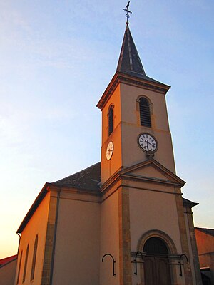
 Saint-Fiacre church |
||
Hunting (German Hüntingen , Lorraine Hënténgen ) is a French commune with 721 inhabitants (as of January 1, 2017) in the Moselle department in the Grand Est region (until 2015 Lorraine ). It belongs to the Arrondissement of Thionville .
geography
Hunting is located a few hundred meters from the right bank of the Moselle , about 13 kilometers northeast of Thionville on the eastern bank of the Moselle at an altitude between 160 and 267 m above sea level. The municipal area covers 3.78 km².
history
The place has belonged to France since 1661, before that it was Luxembourgish.
Population development
| year | 1962 | 1968 | 1975 | 1982 | 1990 | 1999 | 2007 | 2017 |
| Residents | 285 | 278 | 288 | 474 | 580 | 566 | 581 | 721 |
Web links
Commons : Hunting (Moselle) - Collection of images, videos and audio files
