
Hirschberg (Saale)
| coat of arms | Germany map | |
|---|---|---|
.png)
|
Coordinates: 50 ° 24 ' N , 11 ° 49' E |
|
| Basic data | ||
| State : | Thuringia | |
| County : | Saale-Orla district | |
| Height : | 454 m above sea level NHN | |
| Area : | 24.13 km 2 | |
| Residents: | 2132 (Dec. 31, 2019) | |
| Population density : | 88 inhabitants per km 2 | |
| Postal code : | 07927 | |
| Area code : | 036644 | |
| License plate : | SOK, LBS, PN, SCZ | |
| Community key : | 16 0 75 046 | |
City administration address : |
Marktstrasse 2 07927 Hirschberg |
|
| Website : | ||
| Mayor : | Rüdiger Wohl | |
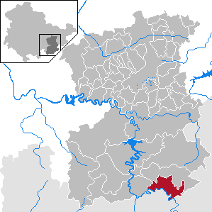
| Location of the city of Hirschberg in the Saale-Orla district | ||
  |
||


Hirschberg is a country town in the south of the Saale-Orla district in Thuringia , on the upper reaches of the Saxon Saale . It borders directly on the Free State of Bavaria .
geography
Neighboring communities are the cities of Rosenthal am Rennsteig and Gefell in the Saale-Orla district and Berg , Köditz and Töpen in the Bavarian district of Hof .
history
A hall crossing was certainly the reason for building a castle and thus the prerequisite for the development of the city of Hirschberg. Only the remains of the tower wall remain from the castle. In 1154 Hirschberg was first mentioned in a document. 1232 was called a "Rudegerus von Hirschberg". Then began changing ownership: In 1296 Rudolf von Habsburg bought the castle and pledged it to the bailiffs of Plauen . In 1357 it was owned by the Wettins . In 1359 the Bohemian crown acquired the fortress. 1480–1664 the Lords of Beulwitz owned the castle. In 1664 Heinrich X. from the Reuss-Lobenstein- Ebersdorf line bought the property and began rebuilding. 1680–1711 there was a sideline of the Reussians on site, the castle served as a residence. During this time a new castle was built, which was further expanded in 1825. Hirschberg remained a Bohemian fiefdom until 1808. From 1920 the castle served residential purposes and as an agricultural administration building.

The first documented mention of the city was in 1296. In 1479 the Bohemian King Vladislav granted city rights. In March 1848, the city was the most important revolutionary center in the Principality of Reuss-Lobenstein-Ebersdorf . After the abdication of Prince Heinrich LXXII. In the same year Lobenstein-Ebersdorf went on in the Schleizer line as Reuss younger line , to which Hirschberg belonged until 1918.
During the Second World War , 77 Eastern workers had to do forced labor in the Knoch leather factory . In April 1945, concentration camp prisoners on a death march were driven from Buchenwald concentration camp to Flossenbürg concentration camp through the Sparnberg district and the Saale , because the bridge had already been blown up. Two prisoners were murdered by SS men and found their final resting place in the Sparnberg cemetery. Two grave monuments remind of what happened.
From 1945 to 1989, Hirschberg was a border town on the inner-German border (in the restricted area , apart from the usual barriers also separated from Bavaria by a wall) and from 1966 onwards the border crossing on the A 9 ( Rudolphstein on the Bavarian side) was named after .
For 500 years, the city's economic development was shaped by leather processing . In the 20th century the Hirschberg leather factory, which was founded in 1741, was at times the largest producer of shoe and sole leather in Germany. Even after the expropriation of the Knoch family in 1947, the VEB Lederfabrik was the economic, but also social and cultural center of the city. In 1992 the company went bankrupt, from 1993 to 1996 the 16 hectare factory was demolished except for the present museum for tannery and town history.
Incorporations
On January 1, 1974, the municipality of Venzka (July 24, 1348) with the district Juchhöh (1713-1715) was incorporated into the city.
On March 8, 1994 Göritz (February 20, 1282) were incorporated with Lehesten , Sparnberg (1202) and Ullersreuth (1327, 13.04).
In brackets: first documentary mention
Population development
.svg)
Development of the population (from 1994: as of December 31):
|
1830: 1.760 1933: 2,915 1939: 2,888 1994: 2,923 1995: 2,846 |
1996: 2,748 1997: 2,749 1998: 2,674 1999: 2,654 2000: 2,666 |
2001: 2,670 2002: 2,653 2003: 2,612 2004: 2,600 2005: 2,569 |
2006: 2,526 2007: 2,493 2008: 2,488 2009: 2,373 2010: 2,352 |
2011: 2,343 2012: 2,440 2013: 2,181 2014: 2,183 2015: 2,168 |
2016: 2,186 2017: 2,121 2018: 2.123 |
- Data source from 1994: Thuringian State Office for Statistics
politics
City council
The local elections on May 25, 2014 led to the following result with a turnout of 54.3%:
| Party / list | Share of votes | Seats |
| WG Hirschberg / SPD | 41.1% | 6th |
| CDU | 15.8% | 2 |
| The left | 11.4% | 2 |
| BI Hirschberg | 31.7% | 4th |
coat of arms
Blazon : “Split by silver and red; in front of the gap a half black eagle with a red crown and red reinforcement, behind an upright left-facing golden stag with a golden tongue. "
The stag alludes to the name of the city, which is apparently related to a Rudegerus de Hirzperc (Rüdiger von Hirschberg), whose family had the stag in the coat of arms. The eagle at the gap is probably the imperial eagle. The oldest seals, such as one with the inscription DES KAEISER PRIVILEG STAETLEINS HIRSBERG AN DER SAAL INSIGEL, date from the 17th century; the older coat of arms shows the same coat of arms, but in different tinctures .
Partnerships
Hirschberg maintains partnerships with the Bavarian municipality of Berg and the Hungarian municipality of Pilismarót . There are also friendly relationships with the nearby towns of Gefell , Tanna , Schleiz and Bad Lobenstein .
Culture and sights
The Saale-Orla-Wanderweg , the Karl-Bock-Weg and the Saale-Radweg lead through Hirschberg .
-2008-03a.jpg)
-2008-03c.jpg)
-2008-03b.jpg)
church
Museums
There is a museum for tannery and city history on the Saale bridge.
Buildings
The Hirschberg Castle towers over the city. A castle was built here at the beginning of the 13th century.
The city's cultural center was one of the first to be built in the Soviet-occupied zone in 1947. After the renovation, it will contain a large hall with around 600 seats and a gallery with 180 seats.
Parks
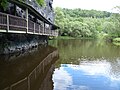
The Hag Nature Park is a wooded rock face with deciduous and coniferous forest directly on the Saale. The Hag can be reached from the city via a hanging walkway along the Saale and from the Schlossberg. The Saale-Orla hiking trail runs through the Hag .
Regular events
The traditional meadow festival has been held annually on the last weekend in August from Thursday to Sunday since 1852, with interruptions during World War II and again since the 1970s.
Economy and Infrastructure
traffic
The city is located between the federal highway 2 and the federal highway 9 .
In 1892, Hirschberg got a connection to the Leipzig – Hof railway line with the Schönberg – Hirschberg railway . The route was used for passenger traffic until 1994 and freight traffic until 2000. The closest train stations are now Grobau on the Plauen - Hof section of the Saxon-Franconian Mainline and Köditz on the Hof-Bad Steben railway , both around eleven kilometers away.
With the lines 710, 721 and 163 of the transport company KomBus there is a bus connection to Schleiz and Plauen .
Industry
The wood processing company Rettenmeier operates a plant here.
sons and daughters of the town
- Hermann von Münch (1813–1883), member of the Bavarian Chamber of Deputies and Mayor of Hof
- Hermann Rönsch (1821–1888), theologian and linguist
- Martin Mutschmann (1879–1947), Gauleiter of the NSDAP and Reich Governor in Saxony
- Otto Zinn (1906–1993), lawyer, politician (NSDAP), Lord Mayor of Gera from 1936 to 1945
- Albin Schöpf , co-founder and first director of the Dresden Zoo
- Hermann Stemmler (1893–1918), painter and graphic artist for the Stuttgart “ Hölzel circle”, killed in war in Rethel

Hirschberg in summer

Longest wooden bench in the Vogtland
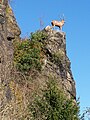
Hirschberg's landmark on a cliff below the Schlossberg

Wenceslas Cave
Hanging walkway


Web links
- Official website of the city
- Information about the museum
- Erwin Purucker: From Rudolphstein to Hirschberg - pictures of the inner German border
Individual evidence
- ^ Population of the municipalities from the Thuringian State Office for Statistics ( help on this ).
- ↑ Michael Köhler: Thuringian castles and fortified prehistoric and early historical living spaces. Jenzig-Verlag Köhler, Jena 2001, ISBN 3-910141-43-9 , p. 140.
- ^ Wolfgang Kahl : First mention of Thuringian cities and villages up to 1300. A manual. 2nd, improved edition. Rockstuhl, Bad Langensalza 2001, ISBN 3-934748-58-9 , p. 31.
- ↑ Thomas Bienert: Medieval castles in Thuringia. 430 castles, castle ruins and fortifications. Wartberg-Verlag, Gudensberg-Gleichen 2000, ISBN 3-86134-631-1 , p. 214.
- ↑ Hirschberg Castle
- ↑ Thuringian Association of the Persecuted of the Nazi Regime - Association of Antifascists and Study Group of German Resistance 1933–1945 (Ed.): Local history guide to sites of resistance and persecution 1933–1945. Volume 8: Thuringia. VAS - Verlag für Akademische Schriften, Frankfurt am Main 2003, ISBN 3-88864-343-0 , p. 222.
- ^ Kai Müller: Ortschronik Ullersreuth. (2013 manuscript).
- ^ Wolfgang Kahl: First mention of Thuringian towns and villages. A manual. 5th, improved and considerably enlarged edition. Rockstuhl, Bad Langensalza 2010, ISBN 978-3-86777-202-0 , pp. 298, 134, 93, 169, 292.
- ↑ Thuringian State Office for Statistics, 2014 municipal council elections in Thuringia - final result for Hirschberg (Saale)
- ↑ Hartmut Ulle: New Thuringian Wappenbuch. Volume 2: Ilmkreis, Jena, Kyffhäuserkreis, Saale-Orla-Kreis, Saalfeld-Rudolstadt (district), Schmalkalden-Meiningen (district), Suhl. 2nd, changed, revised edition. Working group Genealogy Thuringia, Erfurt 1997, ISBN 3-9804487-2-X , p. 36.
- ↑ http://www.stadt-hirschberg-saale.de/inhalte/stadt_hirschberg/_inhalt/partnergemeinden/partnergemeinden (status: 2012)
Bad Lobenstein | Bodelwitz | Dittersdorf | Döbritz | Dreitzsch | Eßbach | Gefell | Geroda | Gertewitz | Görkwitz | Göschitz | Gössitz | Grobengereuth | Hirschberg | Keila | Cherry chew | Kospoda | Krölpa | Langenorla | Lausnitz | Lemnitz | Löhma | Miesitz | Mittelpöllnitz | Moßbach | Moxa | Neundorf (near Schleiz) | Neustadt an der Orla | Nimritz | Oberoppurg | Oettersdorf | Oppurg | Paska | Peuschen | Plot | Pörmitz | Pößneck | Quaschwitz | Ranis | Remptendorf | Rosendorf | Rosenthal am Rennsteig | Saalburg-Ebersdorf | Schleiz | Lubricating seat | Schmorda | Schondorf | Seisla | Solkwitz | Tanna | Tegau | Tommelsdorf | Triptis | Volkmannsdorf | Weira | Wernburg | Wilhelmsdorf | Wurzbach | Ziegenrück