
Mertendorf (Thuringia)
| coat of arms | Germany map | |
|---|---|---|
 Help on coat of arms |
Coordinates: 51 ° 0 ' N , 11 ° 47' E |
|
| Basic data | ||
| State : | Thuringia | |
| County : | Saale-Holzland district | |
| Fulfilling municipality : | Eisenberg | |
| Height : | 335 m above sea level NHN | |
| Area : | 3.79 km 2 | |
| Residents: | 131 (Dec. 31, 2019) | |
| Population density : | 35 inhabitants per km 2 | |
| Postal code : | 07619 | |
| Area code : | 036694 | |
| License plate : | SHK, EIS, SRO | |
| Community key : | 16 0 74 055 | |
| Association administration address: | Market 27 07607 Eisenberg |
|
| Website : | ||
| Mayor : | Erhard hits | |
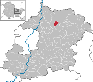
| Location of the community of Mertendorf in the Saale-Holzland district | ||
  |
||


Mertendorf is a municipality in the Saale-Holzland district . The fulfilling municipality is the district town of Eisenberg .
geography
Mertendorf, in the form of a round in eastern Thuringia , is 7 km from the city of Schkölen and the border with Saxony-Anhalt . The distance to Jena is 20 km, to Gera 25 km, to Zeitz 30 km and to Naumburg 25 km. The place is located directly on the 1070 highway between Hermsdorf and Camburg near the Tautenburger Forest . Neighboring towns are the town of Bürgel , Poxdorf , Rockau , Wetzdorf , Poppendorf , Kischlitz , Rauschwitz and Karsdorfberg .
history
Mertendorf was first mentioned in a document in 1252 in connection with construction work on the Lobdeburg near Jena. The village name Mertendorf was around 1800 Mertensdorf. According to legend, the place was not destroyed by Napoleon , because it was surrounded by forest at that time and was not found. In 2012, the community celebrated the 760th anniversary.
Originally, the Tautenburg taverns were masters of the place. After this noble family died out, Mertendorf belonged to the Electoral Saxon Office of Tautenburg from 1640/52 . With the Congress of Vienna in 1815, the place became part of the Grand Duchy of Saxony-Weimar-Eisenach and in 1822 it was incorporated into the Bürgel and Tautenburg office. In 1850 Mertendorf came to the Weimar II administrative district (from 1868: Apolda administrative district ) of the Grand Duchy. Since 1920 the place belongs to the state of Thuringia.
In 1951 the first Thuringian farmers' fair took place in Mertendorf.
→ See also Mertendorf village church
politics
The independent community is led by Mayor Erhard Hit and 6 local councilors. The mayor has been in office since 1995. The city of Eisenberg takes over the administration as a fulfilling municipality. The community is currently active against the planned Thuringian regional reform.
economy
Five companies have settled in the village, including a baked goods store, a heating construction company, a forest planning company, a mail order company and a feed production company. Agriculture is also practiced. Since 2016, the entire site has been connected to the central Mertendorf sewage treatment plant.
Culture
The “Maibaumgesellschaft Mertendorf e. V. "and the" Heimatfreunde Mertendorf e. V. ”are committed to preserving the local culture. Every year, two days after Ascension, the traditional maypole-setting takes place with hundreds of visitors. A 32 m high spruce is erected. The street festival is celebrated in July and the Linden Festival in September. There is a Christmas market on the 2nd weekend in Advent.
Attractions
- Evangelical church ( location → ) from the 17th century with the Marienglocke from the 15th century
- War memorial for the victims of the two world wars
- Historical, Slavic village complex as a round , with the church as the center
- Cemetery with venerable family graves of large landowners and farmers who are respected in the region
- Natural biotope on the way to Bürgel
- "Leite" and the "Pundel" are popular natural hiking destinations
Personalities
- Franz Börner made a name for himself as an innkeeper and house butcher in the region
- Heinrich Pohl created a memorial for himself with the new residents' settlement after the Second World War
Web links
Individual evidence
- ^ Population of the municipalities from the Thuringian State Office for Statistics ( help on this ).
- ^ Karlheinz Blaschke , Uwe Ulrich Jäschke : Kursächsischer Ämteratlas 1790. Scale approx. 1: 200000. Gumnior, Chemnitz 2009, ISBN 978-3-937386-14-0 , p. 34 f.
- ↑ Bürgel at www.geo.viaregia.org
- ↑ Geographical overview of the Saxon-Ernestine, Schwarzburg, Reussian and adjacent lands. Perthes, Gotha 1826, p. 53 .
- ↑ Locations of the administrative district Apolda in the municipality register 1900
Albersdorf | Altenberga | Bad Klosterlausnitz | Bibra | Bobeck | Bremsnitz | Bucha | Bürgel | Crossing the Elster | Dornburg-Camburg | Eichenberg | Eineborn | Eisenberg | Frauenprießnitz | Outdoor orla | Geisenhain | Gneus | Golmsdorf | Gosen | Graitschen at Bürgel | Greater buckedra | Grosseutersdorf | Großlöbichau | Großpürschütz | Gumperda | Hainichen | Hainspitz | Hartmannsdorf | Heathland | Hermsdorf | Hummelshain | Jenalöbnitz | Kahla | Karlsdorf | Little buckedra | Kleinebersdorf | Kleineutersdorf | Laasdorf | Lehesten | Lindig | Lippersdorf-Erdmannsdorf | Löberschütz | Mertendorf | Meusebach | Milda | Möckern | Mörsdorf | Nausnitz | Neuengönna | Oberbodnitz | Orlamünde | Ottendorf | Petersberg | Poxdorf | Rattelsdorf | Rauda | Rauschwitz | Rausdorf | Reichenbach | Reinstädt | Renthendorf | Rothenstein | Ruttersdorf-Lotschen | Scheiditz | Schkölen | Grinding trips | Schlöben | Schöngleina | Schöps | Side rod | Serba | Silbitz | Stadtroda | St. Gangloff | Sulza | Tautenburg | Tautendorf | Tautenhain | Animal snail | Tissa | Trobnitz | Trockenborn-Wolfersdorf | Unterbodnitz | Waldeck | Walpernhain | Waltersdorf | Weissbach | Weißenborn | Wichmar | Rooms | Zollnitz