
Weidingen
| coat of arms | Germany map | |
|---|---|---|

|
Coordinates: 50 ° 1 ' N , 6 ° 23' E |
|
| Basic data | ||
| State : | Rhineland-Palatinate | |
| County : | Eifel district Bitburg-Prüm | |
| Association municipality : | South Eifel | |
| Height : | 434 m above sea level NHN | |
| Area : | 5.84 km 2 | |
| Residents: | 175 (Dec. 31, 2019) | |
| Population density : | 30 inhabitants per km 2 | |
| Postal code : | 54636 | |
| Area code : | 06527 | |
| License plate : | BIT, PRÜ | |
| Community key : | 07 2 32 132 | |
| Community structure: | 2 districts | |
| Association administration address: | Pestalozzistraße 7 54673 Neuerburg |
|
| Website : | ||
| Local Mayor : | Johannes Fandel | |
| Location of the local community Weidingen in the Eifelkreis Bitburg-Prüm | ||
  |
||

Weidingen is a municipality in the Eifel and belongs to the Eifelkreis Bitburg-Prüm in Rhineland-Palatinate . It belongs to the Verbandsgemeinde Südeifel and is still a well-known Marian pilgrimage site today .
geography
Weidingen is on the edge of the South Eifel nature park and consists of the districts Weidingen and Niederweidingen. The residential areas Kalenborn, Rodenhof and Scheuerdell also belong to the Weidingen district .
history
Legend has it that around 730, Saint Willibrord built a church on the site of a pagan temple. An image of the Virgin that had survived the decay over the centuries stood in a willow bush from which the names Weidig , Widen or Wedingen are said to have been derived. In 1205 the predecessor of today's pilgrimage church is attested. Until the end of the 18th century, Weidingen belonged to the rulership of Neuerburg in the Duchy of Luxembourg and was the capital of a dairy farm , which also included Hütterscheid , Niederweidingen and Outscheid .

In 1794 French revolutionary troops occupied the Austrian Netherlands , to which the Duchy of Luxembourg belonged, and annexed it in October 1795 . From 1795 to 1814 the place belonged to the canton Neuerburg in the forest department . Weidingen was the seat of a Mairie .
In 1815, the former Luxembourg area east of the Sauer and Our was assigned to the Kingdom of Prussia at the Congress of Vienna . Thus the place came Weidingen 1816 Bitburg in Trier in the Grand Duchy of the Lower Rhine , which in 1822 Rheinprovinz opened. Weidingen became the official seat of the mayor's office of the same name . The municipalities of Altscheid , Berkoth , Burscheid , Niederweidingen and Uppershausen belonged to the mayor's office .
After the First World War , the area belonged to the French part of the Allied occupation of the Rhineland . After the Second World War , the community of Weidingen within the French occupation zone became part of the then newly formed state of Rhineland-Palatinate .
The church village or today's Weidingen district was formerly also called "Oberweidingen".
The current community was formed on June 7, 1969 from the communities Niederweidingen (39 inhabitants) and Weidingen (187 inhabitants).
- Population development
The development of the population of Weidingen in relation to today's municipal area; the values from 1871 to 1987 are based on censuses:
|
|
politics
Municipal council
The municipal council in Weidingen consists of six council members, who were elected by a majority vote in the local elections on May 26, 2019 , and the honorary local mayor as chairman.
coat of arms
|
|
Blazon : "Under a blue shield head, in it a golden four-pointed crown with red and blue semi-precious stones, divided obliquely on the left, a forked green willow branch in silver in front, a golden church in blue with black windows and aspis, the tower on the left." |
| Justification for the coat of arms: Adoration of the Virgin Mary; depicted in the coat of arms with red and blue (4: 3) semi-precious stones, four-pointed, golden crown of Mary. The forked willow branch not only appears in the coat of arms as a name giver, but also shows the merger of the formerly independent towns of Oberweidingen and Niederweidingen, which have formed the municipality of Weidingen since 1969. Weidingen is a place of pilgrimage with the dominant pilgrimage church of St. Marien. |
Culture and sights

Pilgrimage Church of St. Marien (2019)
Crossroads in Weidingen (Gartenstrasse)


- The predecessor of today's parish and pilgrimage church of the Conception of Mary was built by Count Friedbald von Hamm around 1205. It became a parish church in 1247, and the part from the tower to the confessional still stands today. In 1396 the first church was extended. This gave rise to what is known today as the Old Church , which is often mistakenly viewed as the aisle. To make room, the right wall of the old church was broken through in 1500 to add a larger third church. In 1541 part of the first church was demolished to add a high tower. After being destroyed twice by lightning, the church was rebuilt in 1771 and the tower in 1783. Weidingen is still a well-known place of pilgrimage to Maria - comforter of the sad , the high altar houses the miraculous image.
- The Catholic rectory with an oven extension from the first half of the 19th century (Königsbergstraße).
- Two listed houses from the 18th century (Gartenstrasse).
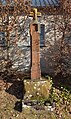
- Weidingen has the oldest niche cross in the region, which is dated to 1636 (Gartenstrasse).
- Another niche cross from 1639 is northwest of the village, on the road to Philippsweiler.
- A manor-like three-sided farm in Niederweidingen; the seven-axle three-storey residential building with barns and connecting buildings was built in 1828 (Michelbachstrasse).
- The grounds of the Foundation for the Promotion of Contemporary Art in Weidingen, designed by Anja Axt and operated by gallery owner Max Hetzler , with guest house and warehouse and annual summer exhibitions of internationally and nationally renowned artists such as Albert Oehlen , Thomas Struth or André Butzer .
- The " Günther Förg Library " with an exhibition room.
See also: List of cultural monuments in Weidingen and List of natural monuments in Weidingen
literature
- Ernst Wackenroder (arr.): The art monuments of the Bitburg district (= Paul Clemen [Hrsg.]: The art monuments of the Rhine province . Volume 12 / I ). Trier 1983, ISBN 3-88915-006-3 , p. 296–301 (315 p., With 12 plates and 227 illustrations in the text. Reprinted by the Schwann edition, Düsseldorf 1927).
- Eifel village school teacher Johann Brand: Weidingen - The legend of a knight from Hamm . In: Johanna and Christian Oberweis-Hauer (Hrsg.): Notes of the outstanding Eifel village school teacher Johann Brand . 2004, p. 131 ( online [PDF; accessed January 29, 2018]).
Web links
- To search for cultural assets of the local community Weidingen in the database of cultural assets in the Trier region .
Individual evidence
- ↑ State Statistical Office of Rhineland-Palatinate - population status 2019, districts, communities, association communities ( help on this ).
- ↑ State Statistical Office Rhineland-Palatinate (ed.): Official directory of the municipalities and parts of the municipality. Status: January 2019 [ Version 2020 is available. ] . S. 101 (PDF; 3 MB).
- ^ Meyers Orts- und Verkehrs-Lexikon des Deutschen Reichs , 1913, p. 1093 ( Google Books )
- ↑ Official municipality directory 2006 ( Memento from December 22, 2017 in the Internet Archive ) (= State Statistical Office Rhineland-Palatinate [Hrsg.]: Statistical volumes . Volume 393 ). Bad Ems March 2006, p. 199 (PDF; 2.6 MB). Info: An up-to-date directory ( 2016 ) is available, but in the section "Territorial changes - Territorial administrative reform" it does not give any population figures.
- ↑ State Statistical Office Rhineland-Palatinate: My village, my city. Retrieved August 7, 2019 .
- ^ The Regional Returning Officer Rhineland-Palatinate: Local elections 2019, city and municipal council elections. Retrieved August 7, 2019 .
- ↑ Weidingen coat of arms
- ^ Foundation for the Promotion of Contemporary Art in Weidingen , accessed on April 6, 2016
- ↑ Outside barn, inside gallery in: Trierischer Volksfreund , accessed on July 14, 2015.
- ↑ Projects: Guest House and Warehouse Weidingen , accessed on April 6, 2016
- ^ Library Günther Förg. Foundation for the Promotion of Contemporary Art in Weidingen, accessed on August 1, 2016 .
Affler | Alsdorf | Altscheid | Ammeldingen on the Our | Ammeldingen near Neuerburg | Bauler | Berkoth | Berscheid | Biesdorf | Bollendorf | Castle | Dauwelshausen | Echternacherbrück | Eisenach | Emmelbaum | Ernzen | Ferschweiler | Fischbach-Oberraden | Geichlingen | Gemünd | Gentingen | Gilzem | Heilbach | Autumn Mill | Holsthum | Hommerdingen | Huts | Hüttingen near Lahr | Irrel | Karlshausen | Kaschenbach | Keppeshausen | Body | Koxhausen | Kruchten | Lahr | Leimbach | Menningen | Mettendorf | Minden | Muxerath | Nasingen | Neuerburg | Niedergeckler | Niederraden | Niederweis | Niehl | Walnut tree | Obergeckler | Peffingen | Plascheid | Prümzurlay | Rodershausen | Roth an der Our | Schankweiler | Log basket | Chafing | Sevenig near Neuerburg | Sinspelt | Überisenbach | Uppershausen | Utscheid | Waldhof-Falkenstein | Wallendorf | Weidingen | Doubt decision