Northumberland County, Pennsylvania
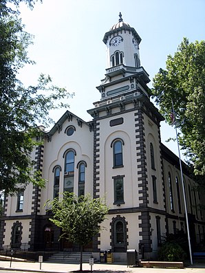
 Northumberland County Courthouse |
|
| administration | |
|---|---|
| US state : | Pennsylvania |
| Administrative headquarters : | Sunbury |
| Address of the administrative headquarters: |
Northumberland County Commissioners' Office Sunbury, PA 17801 |
| Foundation : | March 21, 1772 |
| Made up from: |
Lancaster County Berks County Bedford County Cumberland County Northampton County |
| Area code : | 001 570 |
| Demographics | |
| Residents : | 94,556 (2000) |
| Population density : | 79.4 inhabitants / km 2 |
| geography | |
| Total area : | 1236 km² |
| Water surface : | 45 km² |
| map | |
| Website : www.northumberlandco.org | |
Northumberland County is a county in the state of Pennsylvania in the United States . At the 2000 census , the county had 94,556 people and a population density of 79 people per square kilometer. The county seat is Sunbury .
geography
The county has an area of 1,236 square kilometers, of which 45 square kilometers (4.0%) is water. It falls in the catchment area of the Susquehanna River . Major running waters in the county include (north to south) West Branch Susquehanna River , Chillisquaque Creek , Shamokin Creek, and Mahanoy Creek .
The highest peaks in the county are the 433 m high Mahanoy Mountain and the Little Mountain , which rises in the county to 402 m .
The main roads within the county are:
-
 Interstate 80
-
 Interstate 180
-
 US Highway 11
-
 US Highway 15
-
 Pennsylvania Route 44
-
 Pennsylvania Route 54
-
 Pennsylvania Route 61
-
 Pennsylvania Route 147
history
The county was formed on March 22, 1772 and named after the English county of Northumberland .

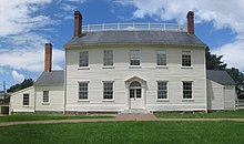
One place in the county has the status of a National Historic Landmark , the Joseph Priestley House . 28 buildings and sites in the county are listed on the National Register of Historic Places (NRHP) (as of July 24, 2018).
Demographics
| Population development | |||
|---|---|---|---|
| Census | Residents | ± in% | |
| 1790 | 17,147 | - | |
| 1800 | 27,797 | 62.1% | |
| 1810 | 36,327 | 30.7% | |
| 1820 | 15,424 | -57.5% | |
| 1830 | 18,133 | 17.6% | |
| 1840 | 20,027 | 10.4% | |
| 1850 | 23,272 | 16.2% | |
| 1860 | 28,922 | 24.3% | |
| 1870 | 41,444 | 43.3% | |
| 1880 | 53,123 | 28.2% | |
| 1890 | 74,698 | 40.6% | |
| 1900 | 90,911 | 21.7% | |
| 1910 | 111,420 | 22.6% | |
| 1920 | 122.079 | 9.6% | |
| 1930 | 128.504 | 5.3% | |
| 1940 | 126,887 | -1.3% | |
| 1950 | 117.115 | -7.7% | |
| 1960 | 104,138 | -11.1% | |
| 1970 | 99,190 | -4.8% | |
| 1980 | 100,381 | 1.2% | |
| 1990 | 96,771 | -3.6% | |
| 2000 | 94,556 | -2.3% | |
| 2010 | 94,528 | -0% | |
| 2015 estimate | 93,246 | -1.4% | |
| 1900-1990
2000 |
|||
At the time of the United States Census 2000, Northumberland County was inhabited by 94,556 people. The population density was 79 people per km². There were 43,164 housing units at an average of 36 per km². The Northumberland County's population was 97.09% White , 1.52% Black or African American , 0.10% Native American , 0.22% Asian , 0.02% Pacific Islander , 0.47% said belonging to other races and 0.58% named two or more races. 1.10% of the population declared to be Hispanic or Latinos of any race.
The residents of Northumberland Counties were distributed in 38,835 households out of which 27.3% had children under the age of 18. 52.4% of households were married, 9.6% had a female head of household without a husband, and 34.1% were not families. 30.2% of households were made up of individuals and someone lived in 15.5% of all households aged 65 years or older. The average household size was 2.34 and the average family size was 2.89 people.
The population was divided into 21.9% minors, 7.0% 18–24 year olds, 27.7% 25–44 year olds, 24.4% 45–64 year olds and 19.0% aged 65 and over or more. The median age was 41 years. For every 100 women there were 96.3 men. For every 100 women over 18, there were 92.8 men.
At the 2000 census, 32.5% had German , 12.9% Polish , 9.9% American , 8.2% Italian , 8.1% Irish, and 5.8% Dutch ancestors. 95.8% of the population spoke English and 1.5% Spanish as their first language spoken.
In 1990, 1167 children were born in Northumberland County. In 2000 the birth rate fell to 919 births. In 2011, 961 babies were born alive.
Townships
Citys and Boroughs
Census-designated places
Micropolitan Statistical Area

The Office of Management and Budget has designated Northumberland County as Sunbury, PA Micropolitan Statistical Area (µSA) . Based on the population of the United States Census 2010 , the Micropolitan Statistical Area ranks with 94,528 inhabitants as the second largest in the state of Pennsylvania and 37th in the United States . Northumberland County is also part of the Bloomsburg-Berwick-Sunbury, PA Combined Statistical Area (CSA), which includes Northumberland County, Columbia County , Montour County , Snyder County and Union County . This Combined Statistical Area was the eighth largest in the state in 2010 with a population of 264,739 and in 115th place nationwide .
Web links
Individual evidence
- ↑ Northumberland County in the United States Geological Survey's Geographic Names Information System . Retrieved February 22, 2011
- ↑ Charles Curry Aiken, Joseph Nathan Kane: The American Counties: Origins of County Names, Dates of Creation, Area, and Population Data, 1950-2010 . 6th edition. Scarecrow Press, Lanham 2013, ISBN 978-0-8108-8762-6 , p. 225 .
- ↑ Listing of National Historic Landmarks by State: Pennsylvania . National Park Service , accessed July 23, 2018.
- ↑ Search mask database in the National Register Information System. National Park Service , accessed July 24, 2018.
- ↑ County Totals Dataset: Population, Population Change and Estimated Components of Population Change: April 1, 2010 to July 1, 2015 ( English ) Retrieved October 18, 2016.
- ↑ Extract from Census.gov . Retrieved February 28, 2011
- ↑ Excerpt from factfinder.census.gov.Retrieved February 28, 2011
- ^ Pennsylvania Department of Health, Birth Age County Reports 1990 and 2011, 2011
- ^ Office of Management and Budget ( English ) In: The White House . Retrieved October 17, 2016.
- ↑ Center for New Media and Promotions (C2PO): 2010 Census ( English ) In: census.gov . Retrieved October 17, 2016.
Coordinates: 40 ° 51 ′ N , 76 ° 43 ′ W

