Roberts County, South Dakota
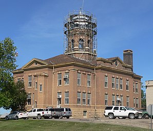
 Roberts County Courthouse |
|
| administration | |
|---|---|
| US state : | South Dakota |
| Administrative headquarters : | Sisseton |
| Address of the administrative headquarters: |
Roberts County Courthouse 411 2nd Ave East Sisseton, SD 57262-1453 |
| Foundation : | 1883 |
| Made up from: | Grant County |
| Area code : | 001 605 |
| Demographics | |
| Residents : | 10,149 (2010) |
| Population density : | 3.6 inhabitants / km 2 |
| geography | |
| Total area : | 2941 km² |
| Water surface : | 88 km² |
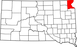
| map | |
| Website : roberts.sdcounties.org | |
The Roberts County is a county in the US -amerikanischen State South Dakota . In 2010 , the county had 10,149 people and a population density of 3.6 people per square kilometer. Up to the estimate in 2012, the population had increased to 10,303. The county seat is in Sisseton .
geography
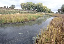
The county is located in the extreme northeast of South Dakota at the intersection of the three states of South Dakota, North Dakota and Minnesota . Along the eastern border with Minnesota, the Traverse Gap as part of the continental divide separates the catchment area of the Hudson Bay, which is reached via Lake Traverse , the Bois de Sioux River , the Red River of the North , Lake Winnipeg and the Nelson River , from the Little Minnesota River . which belongs to the catchment area of the Gulf of Mexico via Big Stone Lake , the Minnesota River and the Mississippi .
The county has an area of 2941 square kilometers and is therefore slightly larger than the Saarland . Of this, 88 square kilometers (3.00 percent) are water.
The following neighboring counties border Roberts County:
|
Richland County, North Dakota |
||
|
Marshall County Day County |

|
Traverse County, Minnesota Big Stone County, Minnesota |
| Grant County |
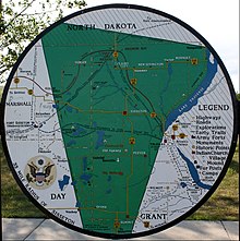
Most of the county is occupied by the Lake Traverse Indian Reservation area. The Indian reservation is home to the Sisseton Wahpeton Oyate , a subgroup of the Dakota . The area of the reservation extends to all neighboring counties in South Dakota and North Dakota.
history
| Population development | |||
|---|---|---|---|
| Census | Residents | ± in% | |
| 1900 | 12,216 | - | |
| 1910 | 14,897 | 21.9% | |
| 1920 | 16,514 | 10.9% | |
| 1930 | 15,782 | -4.4% | |
| 1940 | 15,887 | 0.7% | |
| 1950 | 14,929 | -6% | |
| 1960 | 13,190 | -11.6% | |
| 1970 | 11,678 | -11.5% | |
| 1980 | 10,911 | -6.6% | |
| 1990 | 9914 | -9.1% | |
| 2000 | 10,016 | 1 % | |
| 2010 | 10.149 | 1.3% | |
| 2012 estimate | 10.303 | 1.5% | |
| 1900–1990 2000 2010–2012 | |||
Roberts County was founded in 1883. It was named after S. G. Roberts , a publisher and member of the Legislative Assembly of the Dakota Territory . The first county seat was the now defunct place Travare . Then the county administration files were moved to Wilmot . They stayed there until 1898 when the administrative headquarters were relocated to Sisseton .

Ten structures and sites in the county are listed on the National Register of Historic Places (NRHP) (as of August 8, 2018).
Demographic data
According to the 2010 census , Roberts County had 10,149 people in 3,657 households. The population density was 3.6 inhabitants per square kilometer. Statistically, there were 2.68 people in each of the 3,657 households.
The racial the population was composed of 60.4 percent white, 0.2 percent African American, 35.9 percent Native American, 0.3 percent Asian and other ethnic groups; 3.1 percent were descended from two or more races. Hispanic or Latino of any race was 1.6 percent of the population.
28.5 percent of the population were under 18 years old, 53.8 percent were between 18 and 64 and 17.7 percent were 65 years or older. 49.9 percent of the population was female.
The median income for a household was 41,483 USD . The per capita income was $ 20,357. 21.2 percent of the population lived below the poverty line.
Roberts County localities
|
Other Unincorporated Communities |
structure
In addition to the two cities and eight towns, Roberts County is divided into 30 townships :
|
|
|
See also
Individual evidence
- ^ Roberts County in the United States Geological Survey's Geographic Names Information System.Retrieved February 22, 2011
- ↑ a b c U.S. Census Bureau, State & County QuickFacts - Roberts County, SD Retrieved July 18, 2013
- ^ A b National Association of Counties. Retrieved July 18, 2013
- ^ Extract from Census.gov.Retrieved February 28, 2011
- ^ E-ReferenceDesk - Roberts County, South Dakota.Retrieved July 18, 2013
- ↑ Search mask database in the National Register Information System. National Park Service , accessed August 8, 2018.
- ↑ Missouri Census Data Center - South Dakota ( page no longer available , search in web archives ) Info: The link was automatically marked as defective. Please check the link according to the instructions and then remove this notice. Retrieved July 18, 2013
Web links
Coordinates: 45 ° 37 ′ N , 96 ° 57 ′ W


