
Stundwiller
| Stundwiller | ||
|---|---|---|
.svg)
|
|
|
| region | Grand Est | |
| Department | Bas-Rhin | |
| Arrondissement | Haguenau-Wissembourg | |
| Canton | Wissembourg | |
| Community association | Outre-Forêt | |
| Coordinates | 48 ° 56 ' N , 7 ° 59' E | |
| height | 128-179 m | |
| surface | 3.32 km 2 | |
| Residents | 491 (January 1, 2017) | |
| Population density | 148 inhabitants / km 2 | |
| Post Code | 67250 | |
| INSEE code | 67484 | |
 Mairie Stundwiller |
||

Stundwiller (German Stundweiler ) is a French commune with 491 inhabitants (as of January 1, 2017) in the Bas-Rhin department in the Grand Est region (until 2015 Alsace ). The neighboring communities are Aschbach , Buhl , Hatten and Oberrœdern .
history
From 1871 until the end of the First World War , Stundwiller belonged to the German Empire as part of the realm of Alsace-Lorraine and was assigned to the Weißenburg district in the Lower Alsace district .
Stundwiller merged on July 1, 1974 with Aschbach and Oberrœdern. On January 1, 1988, Stundwiller separated from Aschbach and one year later from Oberrœdern.
Population development
| year | 1910 | 1962 | 1968 | 1975 | 1982 | 1990 | 1999 | 2006 | 2017 |
|---|---|---|---|---|---|---|---|---|---|
| Residents | 368 | 251 | 268 | 283 | 267 | 263 | 371 | 405 | 491 |
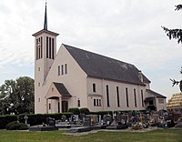
- Church of St. Georg in Stundwiller


- Le Patrimoine des Communes du Bas-Rhin. Flohic Editions, Volume 2, Charenton-le-Pont 1999, ISBN 2-84234-055-8 , p. 1291.
Web links
Commons : Stundwiller - collection of images, videos and audio files