
Věrovany
| Věrovany | |||||
|---|---|---|---|---|---|
|
|||||
| Basic data | |||||
| State : |
|
||||
| Region : | Olomoucký kraj | ||||
| District : | Olomouc | ||||
| Area : | 1781.1366 ha | ||||
| Geographic location : | 49 ° 28 ' N , 17 ° 17' E | ||||
| Height: | 206 m nm | ||||
| Residents : | 1,382 (Jan 1, 2019) | ||||
| Postal code : | 783 76 | ||||
| License plate : | M. | ||||
| traffic | |||||
| Street: | Tovačov - Dub nad Moravou | ||||
| structure | |||||
| Status: | local community | ||||
| Districts: | 3 | ||||
| administration | |||||
| Mayor : | Miroslav Kubíček (as of 2017) | ||||
| Address: | Rakodavy 325 783 75 Dub nad Moravou |
||||
| Municipality number: | 552119 | ||||
| Website : | www.verovany.cz | ||||


Věrovany (German: Wierowann , formerly Werowen ) is a municipality in the Okres Olomouc in the Olomoucký kraj in the Czech Republic . Věrovany is located about 16 kilometers south of Olomouc . The parish covers an area of 17.81 square kilometers and has a population of 1,341 (as of July 3, 2006).
Community structure
The municipality Věrovany consists of the districts Nenakonice ( Nenakonitz ), Rakodavy ( Rakodau ) and Věrovany. The only cadastral district is Věrovany.
Photo gallery

Věrovany, aerial photo (2018)

Statue of Saint John the Baptist

school

Cross near the road to the cemetery
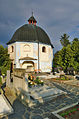
St. Francis Xavier cemetery chapel

Mill


Individual evidence
- ↑ http://www.uir.cz/obec/552119/Verovany
- ↑ Český statistický úřad - The population of the Czech municipalities as of January 1, 2019 (PDF; 7.4 MiB)
- ↑ http://mapy.mzk.cz/mzk03/000/903/901/2619267596/
- ↑ http://www.uir.cz/casti-obce-obec/552119/Obec-Verovany
Web links
Commons : Věrovany - collection of pictures, videos and audio files