Hraničné Petrovice
| Hraničné Petrovice | ||||
|---|---|---|---|---|
|
||||
| Basic data | ||||
| State : |
|
|||
| Region : | Olomoucký kraj | |||
| District : | Olomouc | |||
| Area : | 1215 ha | |||
| Geographic location : | 49 ° 44 ' N , 17 ° 23' E | |||
| Height: | 587 m nm | |||
| Residents : | 146 (Jan 1, 2019) | |||
| Postal code : | 783 06 | |||
| License plate : | M. | |||
| traffic | ||||
| Street: | Dolany - Moravský Beroun | |||
| structure | ||||
| Status: | local community | |||
| Districts: | 1 | |||
| administration | ||||
| Mayor : | Miroslav Dřímalka (as of 2011) | |||
| Address: | Hraničné Petrovice 75 785 01 Šternberk |
|||
| Municipality number: | 546976 | |||
| Website : | www.hranicnepetrovice.cz | |||
Hraničné Petrovice (German Petersdorf ) is a municipality in the Czech Republic . It is located seven kilometers east of Šternberk and belongs to the Okres Olomouc .
geography
Hraničné Petrovice is located in the Domašovská vrchovina ( Domstadtler Uplands ) belonging to the Lower Jeseníky . The village extends in the basin of the Hraničný creek on a pass in the highlands between the valleys of the Trusovický potok and the Bystřice . The road from Jívová to Hraničné Petrovice is the highest in the Okres Oloumouc at 638 m above sea level. To the north rise the Vyhlídka (623 m) and Rýžoviště (603 m), in the southeast the Baba (639 m), south the Hraničný (636 m) and the Skalice (616 m) and in the west the Slunečná (627 m). There is a wind farm to the northwest.
Neighboring towns are Horní Loděnice , Krahulčí and Ondrášov in the north, Petrovický Mlyn, Sedm Dvorů and Nová Véska in the Northeast, Domašov nad Bystřicí the east, the deserted village of Bělá to the southeast, Jívová in the south, Domašov u Šternberka and Těšíkovský Mlyn in the southwest, Těšíkov and Lipina in the west and Nové Dvorce in the north-west.
history
The first written message about the Hranyczny brook was in a document dated September 9, 1220 by Margrave Vladislav Heinrich , which was found to be a forgery from the first half of the 14th century. In it, the margrave allegedly decided in a dispute between the subjects of his wife Hedwig in Lužice and the Hradisko monastery over the forest between Lašťany and the mountains, laying the borderline from Stará Voda along the brook Skřípov and the Bystřice to the field “Bychotino pole “, From there along the path to the Hranyczny brook and on this to the Loděnice border brook .
The first documentary evidence of the village of Hranyczne located to the left of the stream came in 1353 as the property of the Racek von Dolan . Two years later, Hranyczna Bolek from Huzová belonged to him, who gave it to his wife as a morning gift. In 1364, Petersdirf, on the opposite bank of the stream, was first mentioned as part of the episcopal fiefdom Domstadtl . Peter von Sternberg connected the Domstadtl estate with Petersdirf to Medlice Castle at the end of the 14th century. The following owners of the Medlice estates were the Lords of Kravarn , who also acquired the village of Hraničná in 1403 and connected it to Medlice. They held the Lehn Medlice until 1448. At the beginning of the 16th century, both villages belonged to the Sternberg dominion . Other forms of name were on the one hand Petrsdorf (1478), Petersdorf (from 1558), Pettersdorf , Piettersdorf (1599) and Petrovice (from 1720) and on the other hand Hraničný (from 1603). There has been evidence of a hereditary court in Petersdorf since 1588 . The land registers were created in 1642. The registers were kept from 1634 in Jívová and from 1662 in Domašov nad Bystřicí. After the new church was built, a curate was set up in Petersdorf in 1785 and its own registers were created. At the end of the 18th century, the two villages had merged to such an extent that in 1798 they first spoke of a village Hranečné Petrovice . Later the entire place was usually referred to as Petersdorf / Petrovice . In 1834 Petersdorf consisted of 62 houses in which 419 people lived. Until the middle of the 19th century, the place was always subject to Šternberk.
After the lifting of patrimonial formed Petersdorf / Petrovice t. Hranečná from 1850 a municipality in the district administration Sternberg . From 1893 Petrovice t. Hraničné and since 1922 Hraničné Petrovice used as a Czech place name. In 1900, 462 mostly German-speaking residents lived in the 68 houses of the Petersdorf community with the deserted Petersdorfer Mühle and Lerchenfeld areas. Because of the altitude and the stony soil, on which only oats thrive, agriculture barely fed the residents. That is why barrel organs were made in Petersdorf, while another part of the population worked in the two quarries. The Zeschdorfer Sauerbrunn became a popular destination. After the First World War and the collapse of the Austro-Hungarian monarchy, Petersdorf belonged to the Sudetenland province from October 29, 1918, and was assigned to Czechoslovakia in 1919 . In 1926 a double-edged sword 80 cm in length was excavated during shaft work and handed over to the museum in Bärn in 1934 . In 1930 the village, consisting of 81 houses, had 393 inhabitants, in 1939 there were 416.
After the Munich Agreement , Petersdorf was added to the German Reich on October 8, 1938 and assigned to the district of Sternberg . On May 5, 1945, the Red Army took the place. After the end of World War II, the community returned to Czechoslovakia and the German residents were expelled in 1946.
In 1950 the village consisted of 79 houses and had 251 inhabitants. In the course of the territorial reform of 1960, Hraničné Petrovice was incorporated into Domašov nad Bystřicí and at the same time assigned to the Okres Olomouc with the abolition of the Okres Šternberk. In 1970, 240 people lived in the 38 houses of Hraničné Petrovice. The former village school was converted into a tourist hostel.
Community structure
No districts are shown for the municipality of Hraničné Petrovice. The settlements Petrovický Mlýn ( Petersdorf Mill ) and Těšíkovský Mlýn ( Zeschdorfer Mill ) belong to Hraničné Petrovice .
Attractions
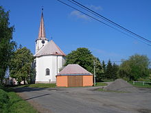
- Church of St. Peter and Paul, built in 1768 in place of an older church. Above the entrance there is a coat of arms stone with the coat of arms of the Princes of Liechtenstein
- Pieta group of statues on the old military road east of the village, created in 1870
- Marble cross in front of the church, created in 1901
- chapel
- Memorial stone for Pastor Gerhard Brix, who died in the bombing of the rectory in May 1945, in the cemetery, unveiled on June 27, 2010
- Zeschdorfer Sauerbrunn ( Těšíkovská kyselka ), ferrous mineral spring west of the village in the valley of the Trusovický potok
- Údolí Bystřice Nature Park
- From the hills around Hraničné Petrovice there is a wide view to Altvater and over the Upper Moravian Basin ( Hornomoravský úval ) to the Drahaner Bergland and Hohenstädter Bergland with the castles Bouzov and Mírov .
Individual evidence
- ↑ http://www.uir.cz/obec/546976/Hranicne-Petrovice
- ↑ Český statistický úřad - The population of the Czech municipalities as of January 1, 2019 (PDF; 7.4 MiB)
- ↑ Místopisný rejstřík obcí českého Slezska a severní Moravy (p. 195) ( Memento of the original from March 4, 2016 in the Internet Archive ) Info: The archive link was inserted automatically and has not yet been checked. Please check the original and archive link according to the instructions and then remove this notice. (PDF; 2.2 MB)


