
Město Libavá
| Město Libavá | |||||
|---|---|---|---|---|---|
|
|||||
| Basic data | |||||
| State : |
|
||||
| Region : | Olomoucký kraj | ||||
| District : | Olomouc | ||||
| Area : | 2932.7351 ha | ||||
| Geographic location : | 49 ° 43 ' N , 17 ° 31' E | ||||
| Height: | 540 m nm | ||||
| Residents : | 598 (Jan. 1, 2019) | ||||
| Postal code : | 783 07 | ||||
| License plate : | M. | ||||
| traffic | |||||
| Street: | Šternberk - Budišov nad Budišovkou | ||||
| structure | |||||
| Status: | local community | ||||
| Districts: | 2 | ||||
| administration | |||||
| Mayor : | Štěpánka Tichá (as of 2016) | ||||
| Address: | Berounská 41 783 07 Město Libavá |
||||
| Municipality number: | 500160 | ||||
| Website : | www.mesto-libava.eu | ||||


Město Libavá (German city of Liebau ) is a municipality in the Czech town of Okres Olomouc ( Olomouc district ). Until the end of 2015 it was a military settlement on the Libavá military training area .
Geographical location
The village is located in the Sudetes on Libavský potok in the Oder Mountains , about 30 km northeast of Olomouc .
history
In 1929 there were 345 houses with 2,237 inhabitants in the town of Liebau . Of these, 2,181 were Germans (German-speaking Moravians ) and 21 were Czechs .
Through the Munich Agreement , the city of Liebau was assigned to the German Reich : in 1945 the city belonged to the district of Bärn in the administrative district of Troppau in the Reichsgau Sudetenland .
After the Second World War , the German-speaking population was expelled to Germany . Immediately afterwards, the entire area around the city was used as a military training area for military purposes.
Město Libavá was the center of the restricted military area until it was downsized on January 1, 2016. The NATO troops practice here for various types of operations. The administration of the village was military, not civil.
On 10 and 11 February 2012 in Město Libavá a place of inquiry instead, practically a local referendum was tantamount. The question was whether the residents would like to join a neighboring community or the re-emergence of an independent community. 49.9% of those entitled took part in the survey , and 97.8% of the participants voted for the creation of an independent community, which also includes the Heroltovice district . Only 1.7% voted against this. The result was legally binding.
In the course of the downsizing of the military training areas and in accordance with the decision of the large majority of residents, Město Libavá and the Heroltovice district left the military administration on January 1, 2016 (not January 1, 2015, as planned earlier) and has been training one since then independent municipality with the old name.
On a square in the center of the village, a memorial stone commemorates the so-called “Black Barons” (“Černí baroni”), who were obliged to do forced labor in the technical auxiliary battalions ( Pomocný technický prapor ) between 1950 and 1954 .
Demographics
| year | Residents | Remarks |
|---|---|---|
| 1834 | 1,522 | |
| 1900 | 2,483 | German residents |
| 1930 | 2.113 | |
| 1939 | 2,185 |
In 1991 the place had 361 inhabitants. In 2001 Město Libavá consisted of 123 houses in which 585 people lived.
Community structure
The municipality of Město Libavá consists of the districts Heroltovice ( Herlsdorf ) and Město Libavá ( town of Liebau ). Basic settlement units are Dřemovice ( Drömsdorf ), Heroltovice, Město Libavá and Stará Voda ( backwater ). Město Libavá also includes the locality Předměstí Libavá ( suburb Liebau ) and the desert area Bělá ( Seibersdorf ).
The municipality is divided into the cadastral districts of Město Libavá, Město Libavá I and Město Libavá II.
Sons and daughters of the church
- Johannes Oesterreicher (1904–1993), Catholic theologian and representative of Jewish-Catholic understanding
- Ignaz Czapka (1791–1881), Mayor of Vienna (1838–1848).

Panoramic view of Město Libavá
Destroyed southwest side of the center of Město Libavá

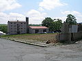
North-east side of the center of Město Libavá

North-western side of the center of Město Libavá


Individual evidence
- ↑ http://www.uir.cz/obec/500160/Mesto-Libava
- ↑ Český statistický úřad - The population of the Czech municipalities as of January 1, 2019 (PDF; 7.4 MiB)
- ↑ Overview of the results of the inquiry in the military restricted area Libavá 10. – 11. February 2012 , press release, February 13, 2012 (Czech)
- ↑ Four new municipalities will arise in the Czech Republic (Czech)
- ↑ http://zpravy.idnes.cz/v-cesku-vzniknou-ctyri-nove-obce-prvniho-starostu-si-zvoli-i-libava-11v-/domaci.aspx?c=A120213_120805_domaci_jw (Czech)
- ↑ Path finder: [CZ] Hard on the border IV: By bike from Olomouc to the Beskidenfuß. In: outdoorseiten.net. April 18, 2013, accessed January 6, 2018 .
- ^ Gregor Wolny : The Margraviate of Moravia. Described topographically, statistically and historically . 2nd edition, Volume 1: Prerauer Kreis . Brno 1846, pp. 281-283.
- ^ Meyer's Large Conversational Lexicon . 6th edition, Volume 12, Leipzig and Vienna 1908, pp. 525-526.
- ^ A b Michael Rademacher: German administrative history from the unification of the empire in 1871 to the reunification in 1990. Bärn district. (Online material for the dissertation, Osnabrück 2006).
- ↑ http://www.uir.cz/casti-obce-obec/500160/Obec-Mesto-Libava
literature
- Gregor Wolny : The Margraviate of Moravia. Described topographically, statistically and historically . 2nd edition, Volume 1: Prerauer Kreis . Brno 1846, pp. 281-283.