Dub nad Moravou
| Dub nad Moravou | ||||
|---|---|---|---|---|
|
||||
| Basic data | ||||
| State : |
|
|||
| Region : | Olomoucký kraj | |||
| District : | Olomouc | |||
| Area : | 1523 ha | |||
| Geographic location : | 49 ° 29 ' N , 17 ° 17' E | |||
| Height: | 212 m nm | |||
| Residents : | 1,637 (Jan 1, 2019) | |||
| Postal code : | 783 75 | |||
| License plate : | M. | |||
| traffic | ||||
| Street: | Prostějov - Přerov | |||
| structure | ||||
| Status: | Městys | |||
| Districts: | 3 | |||
| administration | ||||
| Mayor : | Vítězslav Křesina (as of 2011) | |||
| Address: | Brodecká 1 783 75 Dub nad Moravou |
|||
| Municipality number: | 501794 | |||
| Website : | www.dubnadmoravou.cz | |||
Dub nad Moravou (German Dub an der March ) is a minority town in the Czech Republic . It is located 14 km south of the city of Olomouc on the March and belongs to the Okres Olomouc , Moravia .
history
The first written mention of the place comes from the year 1141. In the 13th century the first church was built. The second house of God "All Saints" was built on its foundation stones in 1586. On July 14, 1848, the place was raised to a town with the right to hold its own market. Since 2006, Dub has again had the status of a mesty .
The main attraction of Dub is the pilgrimage church “ Purification of the Virgin Mary ”, built between 1734 and 1756.
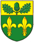
The place name Dub means oak in German , which is what the oak leaf in the city's coat of arms aims at.
Community structure
The municipality consists of the districts Bolelouc ( Bolelautz ), Dub nad Moravou ( Dub on the March ) and Tučapy ( Tutschap ).
Web links
- Website of the municipality (Czech)


