Breza, Bosnia and Herzegovina
Breza
Breza | |
|---|---|
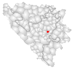
 Location of Breza within Bosnia and Herzegovina. | |
| Country | |
| Population (1991 census) | |
| • Total | 17,317 |
| Time zone | UTC+1 (CET) |
| • Summer (DST) | UTC+2 (CEST) |
Breza is a town and municipality in central Bosnia and Herzegovina, famous for the local mining activities and production of coal. It covers an area of 73 km2 (28 sq mi) and is part of the Zenica-Doboj Canton and the Federation of Bosnia and Herzegovina.
About Breza
Total area of municipality of Breza is 83 square kilometers. It is located in Zenica-Doboj Cantons and it borders with four municipalities; Ilijaš, Kakanj, Vareš and Visoko. Its economic environment is based on coalmine, which was established in year 1907.
Demographics
1971
14.824 total
- Muslims - 10.659 (71,90%)
- Serbs - 2.333 (15,73%)
- Croats - 1.446 (9,75%)
- Yugoslavs - 225 (1,51%)
- Others - 161 (1,11%)
1991
In the 1991 census, the municipality of Breza had 17,317 residents: 13,079 Bosniaks, 851 Croats, 2,122 Serbs, and 1,265 others.
2001
Breza was spared major destruction during the War. However, the population of the area had been reduced to 13,848 residents in 2001 estimation. Ethnically, the municipality of Breza is now overwhelmingly Bosniak.
2005
In 2005, 95% of population of the municipality were ethnic Bosniaks.
Places in the municipality
Banjevac, Breza,

