Aigues-Vives (Aude)
|
Aigues-Vives Aigas Vivas |
||
|---|---|---|

|
|
|
| region | Occitania | |
| Department | Aude | |
| Arrondissement | Carcassonne | |
| Canton | Le Haut-Minervois | |
| Community association | Carcassonne Agglo | |
| Coordinates | 43 ° 14 ' N , 2 ° 32' E | |
| height | 55-109 m | |
| surface | 10.21 km 2 | |
| Residents | 584 (January 1, 2017) | |
| Population density | 57 inhabitants / km 2 | |
| Post Code | 11800 | |
| INSEE code | 11001 | |
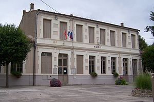
 The Mairie of Aigues-Vives |
||
Aigues-Vives ( Occitan : Aigas Vivas ) is a French commune with 584 inhabitants (as of January 1, 2017) in the Aude department ( Occitania region ). The inhabitants of the village in the Minervois call themselves "Aigues-Vivois".
location
Aigues-Vives is a good 17 kilometers (driving distance) east of Carcassonne . The two places Rieux-Minervois and Caunes-Minervois are 8 kilometers northeast and 14 kilometers north, respectively.
Population development
| year | 1968 | 1975 | 1982 | 1990 | 1999 | 2007 | 2017 |
| Residents | 518 | 514 | 480 | 464 | 481 | 504 | 584 |
history
By chance, at the beginning of the 20th century, about two kilometers northwest of Aigues-Vives near Saint-Jean, a large number of finds (ceramic shards, pieces of bones, etc.) were brought to light, which date back to an Iron Age (3rd / 2nd century BC) .) and Gallo-Roman (approx. 1st century BC to 5th century AD) settlement of the place. However, this place of unknown name was gradually abandoned by its inhabitants in favor of Aigues-Vives in the high Middle Ages. It is known that in 1269 nobody lived there anymore.
The beginnings of the history of Aigues-Vives itself are largely in the dark. In the year 994 a place called Aquaviva is mentioned for the first time, which was developed into a castrum , i.e. a fortified settlement, in the 12th and 13th centuries . The still existing tour carré probably belonged to this castrum . From the 14th to the 16th century the population of the place was constant at around 100 to 150 people, after which it increased slowly but steadily. The highest population with around 500 to 650 people was reached at the beginning of the 20th century.
In 1999 parts of the town were flooded meters high after persistent rainfall.
Attractions
- A donjon ( tour carré ) still around 20 meters high today was formerly part of a larger fortification and probably dates from the 12th century. The original access is about 5 meters above street level and was only accessible via ladders. Up to a height of about 6 meters, the thickness of the masonry is 1.80 meters, above it only 1.20 meters.
- The Église Saint-Alexandre dates from the 12th / 13th centuries. In the 19th century, however, the interior was later redesigned in Gothic forms. The bell tower is dated to 1562.
- The Étang de Marseillette , only about 500 meters from the town , a former bay, was a salt lake of around 2000 hectares in the Middle Ages. From today's perspective it was a beautiful biotope with all kinds of small animals (dragonflies, crabs etc.) as well as fish and birds; however, the residents of the surrounding towns at that time saw it as a source of plagues (mosquitoes) and diseases ( marsh fever, etc.). Already at the time of Henry IV there were plans to dry the lake with the help of Dutch specialists, but all the measures taken were unsuccessful and drove the private donors to ruin. During the French Revolution, plans were again put forward and put into action, but the result was a barren salt steppe. In 1850, Italian specialists dug canals and tunnels, and the water from the Aude was poured into the basin, gradually washing away the salt. Since then, the huge uninhabited areas of the former lake and swamp area have been used for agriculture by the surrounding communities.
