Salles-sur-l'Hers
| Salles-sur-l'Hers | ||
|---|---|---|

|
|
|
| region | Occitania | |
| Department | Aude | |
| Arrondissement | Carcassonne | |
| Canton | La Piège au Razès | |
| Community association | Castelnaudary Lauragais Audois | |
| Coordinates | 43 ° 18 ' N , 1 ° 47' E | |
| height | 205-335 m | |
| surface | 19.31 km 2 | |
| Residents | 701 (January 1, 2017) | |
| Population density | 36 inhabitants / km 2 | |
| Post Code | 11410 | |
| INSEE code | 11371 | |
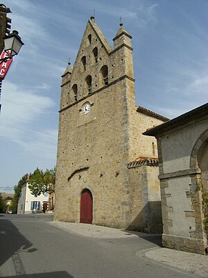
 Salles-sur-l'Hers - church with bell gable |
||
Salles-sur-l'Hers is a southern French municipality with 701 inhabitants (as of January 1, 2017) in the Aude department in the Occitania region .
location
Salles-sur-l'Hers is located on the Hers River in the heart of the Lauragais at an altitude of about 220 meters above sea level. d. M. and about 58 kilometers (driving distance) northwest of Carcassonne and about 18 kilometers southwest of Castelnaudary .
Population development
| year | 1962 | 1968 | 1975 | 1982 | 1990 | 1999 | 2006 | 2016 |
| Residents | 578 | 538 | 528 | 528 | 476 | 540 | 570 | 699 |
In the 19th century the place always had between 900 and 1,200 inhabitants. The mechanization of agriculture has since led to a significant decline in the number of inhabitants.
economy
The area around the village is still characterized by agriculture, which in the late Middle Ages and early modern times mainly concentrated on the cultivation of woad ( pastel ). The import of indigo led to a gradual economic decline from the 18th century; the farmers had to return to 'normal' agriculture. At the end of the 20th century, tourism in the form of the rental of holiday apartments ( gîtes ) was added as an economic factor.
history
No information is currently available on the history of the place.
Attractions
- The small medieval parish church of Salles was rebuilt in the 17th century after being destroyed during the religiously motivated conflicts between Catholics and Protestants ( Huguenot Wars ). The most striking component of the single-nave church is the bell gable, accompanied by side turrets, above the otherwise completely unadorned western facade. Its triangular structure offers space for six free-swinging bells; it was already recognized as a Monument historique in 1926 . The church in the neighboring village of Payra-sur-l'Hers shows a reduced version.
- From the 15th and 16th century castle, which was destroyed in the wars of religion, there is still a fortified tower ( donjon ), which has also been recognized as a monument historique since 1948 .
Web links
Individual evidence
- ↑ Clocher de l'Église Saint-Mathieu, Salles-sur-l'Hers in the Base Mérimée of the French Ministry of Culture (French)
- ^ Donjon, Salles-sur-l'Hers in the Base Mérimée of the French Ministry of Culture (French)
