Montolieu
| Montolieu | ||
|---|---|---|

|
|
|
| region | Occitania | |
| Department | Aude | |
| Arrondissement | Carcassonne | |
| Canton | La Malpère à la Montagne Noire | |
| Community association | Carcassonne Agglo | |
| Coordinates | 43 ° 19 ′ N , 2 ° 13 ′ E | |
| height | 123-407 m | |
| surface | 23.65 km 2 | |
| Residents | 846 (January 1, 2017) | |
| Population density | 36 inhabitants / km 2 | |
| Post Code | 11170 | |
| INSEE code | 11253 | |
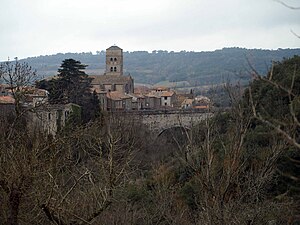
 Montolieu - town view |
||
Montolieu is a municipality in southern France with 846 inhabitants (as of January 1, 2017) in the Aude department in the Occitanie region . The inhabitants are called Montolivains .
location
Montolieu is located at the confluence of the small river Dure in the Rougeanne at an altitude of about 190 meters above sea level. d. M. and about 20 kilometers (driving distance) northwest of Carcassonne or about ten kilometers northeast of the canton capital Alzonne .
Population development
| year | 1962 | 1968 | 1975 | 1982 | 1990 | 1999 | 2006 | 2011 |
| Residents | 899 | 896 | 837 | 852 | 807 | 786 | 763 | 795 |
In the 19th century the place always had between 1,400 and 1,650 inhabitants. The mechanization of agriculture and the associated loss of jobs has since led to a significant decline in the number of inhabitants.
economy
The area around the village is still characterized by agriculture, which in the late Middle Ages and early modern times specialized in the cultivation of woad ( pastel ). The import of indigo led to a gradual economic decline from the 18th century and the farmers turned back to 'normal' agriculture, which however did not generate much profit. Wine has been grown in the region since Roman times; the place is now part of the Cabardès wine region (AOC) . At the end of the 20th century, tourism in the form of the rental of holiday apartments ( gîtes ) was added as an economic factor.
history
A menhir from around 3500 BC stands in the municipality . Chr .; Some old stones with fist-sized bowl-shaped depressions ( pierres á cupules ) can also be seen. Remnants of slag indicating the production of iron were found, as were a large number of fragments of amphorae from Roman and Gallo-Roman times . Today's church was built in the 13th century - it is unclear whether it was on the site of a previous building. Nothing is known about the destruction during the Albigensian Crusades (1209–1229), the Hundred Years War (1337–1453), the Huguenot Wars (1562–1598) or the French Revolution (1789–1815).
Attractions
- The late Gothic parish church ( Église Saint-André ) is rather a rarity among the sacred buildings in the south of France, which are mostly dominated by the Romanesque ; it originally dates back to the 13th century, but has been supplemented and restored again and again in the following years. Its exterior is dominated by a massive tower on the south side , but with multiple steps with cornices . The rich and well-worth seeing baroque furnishings of the single-nave church, which has side chapels , comes partly from other churches in the area that were closed during the French Revolution. The building has been recognized as a monument historique since 1972 .
- The Manufacture Royale is a building from the 18th century that used to house a textile factory. The building was listed as a Monument Historique in 2004 .
- A dainty but artfully forged iron cross from the 16th or 17th century was recognized as a Monument historique as early as 1948 .
Others
- Montolieu is one of several book villages in France.
Personalities
- Kevin Ayers (1944–2013), guitarist in the Soft Machine group , lived and died in Montolieu.
- The German writer Patrick Süskind lives in Munich and Seeheim as well as in Montolieu.
Web links
- Montolieu, Église Saint-André - photo
- Montolieu, Église Saint-André - photo
- Montolieu, Église Saint-André - photo
Individual evidence
- ↑ Église Sainte-André, Montolieu in the Base Mérimée of the French Ministry of Culture (French)
- ↑ Manufacture royale, Montolieu in the Base Mérimée of the French Ministry of Culture (French)
- ↑ Croix en fer forgée, Montolieu in the Base Mérimée of the French Ministry of Culture (French)


