Couffoulens
|
Couffoulens Confolenç |
||
|---|---|---|

|
|
|
| region | Occitania | |
| Department | Aude | |
| Arrondissement | Carcassonne | |
| Canton | Carcassonne-2 | |
| Community association | Carcassonne Agglo | |
| Coordinates | 43 ° 9 ' N , 2 ° 18' E | |
| height | 116-260 m | |
| surface | 9.47 km 2 | |
| Residents | 601 (January 1, 2017) | |
| Population density | 63 inhabitants / km 2 | |
| Post Code | 11250 | |
| INSEE code | 11102 | |
| Website | http://www.couffoulens.fr/ | |
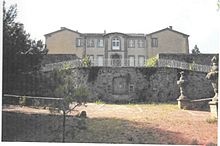
 Panorama of Couffoulens |
||
Couffoulens ( Occitan : Confolenç ) is a municipality with 601 inhabitants (as of January 1, 2017) in southern France in the Aude department . It belongs to the Arrondissement of Carcassonne and the Canton of Carcassonne-2 (until 2015: Canton Carcassonne-1 ). The inhabitants are called Couffoulénois .
geography
Couffoulens is about seven kilometers southwest of the city center of Carcassonne . The Aude flows through the municipality , into which the Lauquet flows. Couffoulens is surrounded by the neighboring municipalities of Carcassonne in the north and northeast, Cavanac in the east and northeast, Leuc in the east and southeast, Verzeille in the southeast, Pomas in the south, Rouffiac-d'Aude in the southwest, Preixan in the west and southwest and Roullens in the west and Northwest.
Population development
| year | 1962 | 1968 | 1975 | 1982 | 1990 | 1999 | 2006 | 2013 |
| Residents | 526 | 527 | 464 | 478 | 549 | 541 | 571 | 632 |
| Sources: Cassini and INSEE | ||||||||
Attractions
- Couffoulens Castle, former castle complex, monument historique since 1948

