Palaja
|
Palaja Palajan |
||
|---|---|---|

|
|
|
| region | Occitania | |
| Department | Aude | |
| Arrondissement | Carcassonne | |
| Canton | Carcassonne-2 | |
| Community association | Carcassonne Agglo | |
| Coordinates | 43 ° 10 ′ N , 2 ° 23 ′ E | |
| height | 140-440 m | |
| surface | 14.69 km 2 | |
| Residents | 2,357 (January 1, 2017) | |
| Population density | 160 inhabitants / km 2 | |
| Post Code | 11570 | |
| INSEE code | 11272 | |
| Website | www.mairie-palaja.fr | |
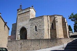
 Saint-Etienne church |
||
Palaja ( Occitan : Palajan ) is a municipality with 2,357 inhabitants (as of January 1, 2017) in southern France and a prefecture of the Aude department . It belongs to the municipality association Carcassonne Agglo , the Arrondissement Carcassonne and the canton Carcassonne-2 (until 2015: canton Carcassonne-1 ). The inhabitants are called Palajanais .
geography
Palaja is about six kilometers south of the city center of Carcassonne . The village itself lies on the small river Fount Guihen , the Bazalac borders the community in the east. Palaja is surrounded by the neighboring communities of Carcassonne in the north, Montirat in the east, Mas-des-Cours in the south-east, Villefloure in the south, Leuc in the south-west, Cavanac in the west and Cazilhac in the west and north-west.
The A61 car route runs along the northern edge of the municipality .
Population development
| year | 1968 | 1975 | 1982 | 1990 | 1999 | 2006 | 2017 | |
| Residents | 288 | 269 | 1017 | 1503 | 1851 | 2128 | 2357 | |
| Source: Cassini and INSEE | ||||||||
Attractions
- Saint-Étienne church, a historic monument since 1961
- Tower of Cazaban, monument historique since 1953
- Old pottery kiln, monument historique since 1963
economy
Mainly wine of the appellation Cité de Carcassonne is produced here.
