Cabrespine
|
Cabrespine Cabrespina |
||
|---|---|---|

|
|
|
| region | Occitania | |
| Department | Aude | |
| Arrondissement | Carcassonne | |
| Canton | Le Haut-Minervois | |
| Community association | Carcassonne Agglo | |
| Coordinates | 43 ° 22 ′ N , 2 ° 28 ′ E | |
| height | 275-943 m | |
| surface | 17.56 km 2 | |
| Residents | 176 (January 1, 2017) | |
| Population density | 10 inhabitants / km 2 | |
| Post Code | 11160 | |
| INSEE code | 11056 | |
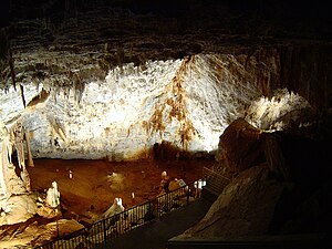
 Gouffre de Cabrespine |
||
Cabrespine ( Occitan : Cabrespina ) is a French commune with 176 inhabitants (as of January 1, 2017) in the Aude department of the Occitania region in France . Its inhabitants are called Cabrespinois .
location
The small village of Cabrespine is located around 25 kilometers northeast of Carcassonne at an altitude of around 310 meters above sea level. d. It is close to the Haut-Languedoc Regional Nature Park ( Parc naturel régional du Haut-Languedoc ) on the edge of the Montagne Noire , crouched deep into the Clamoux Valley, which falls from the Pic de Nore in picturesque gorges and flows straight south to the Orbiel . It is part of the Minervois landscape and the Cabardès wine region .
Population development
| year | 1968 | 1975 | 1982 | 1990 | 1999 | 2006 | 2017 |
| Residents | 190 | 218 | 192 | 193 | 195 | 188 | 176 |
At the beginning of the 19th century, Cabrespine was an important community with many wealthy traders and craftsmen. In 1851 Cabrespine had more than 850 inhabitants. But the phylloxera crisis and the mechanization of agriculture led to a population decline, which only came to a standstill in the last few decades.
economy
The residents of Cabrespine lived for a long time as self-sufficient on the farm, which of course also included viticulture - the red, rosé and white wines produced in the municipality are marketed through the appellations Aude , Languedoc , Pays Cathare , Minervois and Pays d'Oc . But tree crops such as chestnuts and olives as well as agriculture with wheat and potatoes also play an important role. Sheep and goats were also raised for the wool, cheese, and meat. Of the three annual markets, the one on the first Monday of August, established by a royal decree of 1845, was dedicated to the trade in woolly animals and chestnut staves.
Today, however, new residents are moving into the preserved village structure. Whether you are here for a short time in summer or all year round, you definitely want to spend another summer or even part of your life in the village.
history
At the time of the Roman conquest, secondary roads ran through Cabrespine to the Via Domitia , which made iron ore mines accessible to exploitation. The mines were closed for a long time and then came back into operation in the last century. Today there are still mining heaps and connecting passages.
Cabrespine (from lat . Caput spina , dt. About 'mandrel tip') belonged since the time of Charlemagne and until the French Revolution to de Lagrasse Abbey Sainte-Marie . In 814, a statute of Ludwig the Pious mentions that there was a cella in Cabrespine , a branch monastery with which the Lagrasse Abbey reduced its own overcrowding and the monitoring of the local domain was made possible by the few monks who took up residence there. Today only a few increasingly unrecognizable ruins remain of the building.
During the Carolingian era, there were two church buildings: the Chapel of the Madonna of God, next to today's cemetery, with a wall as the only remaining remnant, and St. Peter's Church. From the old building in Romanesque style only a white marble slab, carved in the style of the Merovingian period , is left, which is installed in today's successor church, built in 1753 on the same site.
There was a castle, only a few fragments of it remained , dated 1035, i.e. the Capetian period. Originally a royal castle, Simon IV. De Montfort donated it to Lagrasse Abbey in 1217 as a penance for his misdeeds. After it had reverted to the crown around 1327, it was attacked one after another by the Huguenots and recaptured by the Catholics in 1584 .
Attractions
- Only a few remains of the castle ( château ) mentioned in 1035 remain. During the Albigensian Crusades (1209-1229) it came into the hands of the Abbey of Sainte-Marie de Lagrasse . Around 1327 it became a crown domain and in the Huguenot Wars (1568–1592) they were destroyed by both parties.
- The parish church ( Église Saint-Pierre-ès-Liens ) is a building from the 18th century. Several items of equipment from this time are protected (→ web link).
- The great Cabrespine cave ( Gouffre de Cabrespine ) was already known in the 16th century, but was not rediscovered until 1970; it lies above the village and has been open to the public in parts since 1988. Some stone formations made of aragonite are remarkable , which are only found here in this size. Indications of prehistoric human use have also been found in the cave.
- In the vicinity of Cabrespine there are the remains of several herdsmen's huts ( burons ) built using dry stone masonry technology , which served as shelters for shepherds in the wind and rain. At the same time, goat and sheep cheese was made here during the hot summer months.
Personalities
- Pierre Duhem (* 1861 in Paris; † 1916 in Cabrespine), French physicist and science theorist / historian

