Blount County, Tennessee
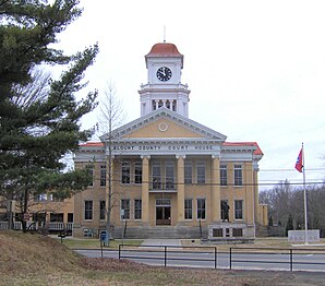
 Blount County Courthouse |
|
| administration | |
|---|---|
| US state : | Tennessee |
| Administrative headquarters : | Maryville |
| Address of the administrative headquarters: |
County Courthouse 341 Court Street Maryville, TN 37804-5906 |
| Foundation : | July 11, 1795 |
| Made up from: | Knox County |
| Area code : | 001 865 |
| Demographics | |
| Residents : | 123,010 (2010) |
| Population density : | 85 inhabitants / km 2 |
| geography | |
| Total area : | 1468 km² |
| Water surface : | 21 km² |
| map | |
| Website : www.blounttn.org | |
The Blount County is a county in the US -amerikanischen State Tennessee . In 2010 , the county had 123,010 residents and a population density of 85 people per square kilometer. By 2013 the population increased to 125,099. The county seat is Maryville .
Blount County is located in the Knoxville Metropolitan Area , the metropolitan area around the city of Knoxville .
geography
The county is located in eastern Tennessee in the Appalachian Mountains , whose main ridge forms the border with North Carolina . It has an area of 1468 square kilometers, of which 21 square kilometers are water.
In the northwest, the county is bounded by the Tennessee River , which is part of the Mississippi River basin across the Ohio . In the southwest, the county is bounded by the Little Tennessee River , which flows into the Tennessee River in neighboring Loudon County to the west.
The following neighboring counties border Blount County:
| Knox County | ||
| Loudon County |

|
Sevier County |
| Monroe County |
Graham County ( North Carolina ) |
Swain County, North Carolina |
The county is located in the Appalachian Great Smoky Mountains , the distinctive peaks of which are within the county of Chilhowee Mountain and Thunderhead Mountain . Part of it is protected as the Great Smoky Mountains National Park. Fort Loudon Lake and Chilhowee Lake are lakes in the area.
history
| Population development | |||
|---|---|---|---|
| Census | Residents | ± in% | |
| 1900 | 19.206 | - | |
| 1910 | 20,809 | 8.3% | |
| 1920 | 28,800 | 38.4% | |
| 1930 | 33,989 | 18% | |
| 1940 | 41,116 | 21% | |
| 1950 | 54,691 | 33% | |
| 1960 | 57,525 | 5.2% | |
| 1970 | 63,744 | 10.8% | |
| 1980 | 77,770 | 22% | |
| 1990 | 85,969 | 10.5% | |
| 2000 | 105,823 | 23.1% | |
| 2010 | 123.010 | 16.2% | |
| 2013 estimate | 125.099 | 1.7% | |
| 1900–1990 2000 2010–2013 | |||
Blount County was formed on July 11, 1795 from parts of Knox County. It was named after William Blount , a US Senator from Tennessee and a member of the Constituent Assembly (Constitutional Convention) of North Carolina and a signatory to the United States Constitution .

75 buildings and sites in the county are listed on the National Register of Historic Places (NRHP) (as of August 9, 2018).
population
According to the 2010 census , Blount County had 123,010 people in 48,728 households. The population density was 85 inhabitants per square kilometer. Statistically, 2.5 people lived in each of the 48,728 households.
The racial the population was composed of 94.2 percent white, 2.9 percent African American, 0.4 percent Native American, 0.9 percent Asian and other ethnic groups; 1.5 percent were descended from two or more races. Hispanic or Latino of any race was 3.0 percent of the population.
21.4 percent of the population were under 18 years old, 60.7 percent were between 18 and 64 and 17.9 percent were 65 years or older. 51.5 percent of the population were female.
The median income for a household was 45,991 USD . The per capita income was $ 23,788. 13.7 percent of the population lived below the poverty line.
Localities in Blount County
Citys , Towns and Census-designated places (CDP) :
| place | Residents 2010 |
Type |
|---|---|---|
| Maryville | 27,258 | City |
| Seymour 1 | 10,919 | CDP |
| Alcoa | 8449 | City |
| Eagleton Village | 5052 | CDP |
| Louisville | 2439 | Town |
| Wildwood | 1098 | CDP |
| Friendsville | 890 | City |
| Rockford | 798 | City |
| Townsend | 448 | City |
| Walland | 259 | CDP |
1 - predominantly in Sevier County
Other unincorporated communities not recorded separately from the census :
structure
Blount County is divided into 10 numbered districts:
|
|
See also
Individual evidence
- ↑ Blount County in the United States Geological Survey's Geographic Names Information System.Retrieved February 22, 2011
- ↑ a b c U.S. Census Bureau, State & County QuickFacts - Blount County, TN Retrieved December 17, 2014
- ↑ a b National Association of Counties.Retrieved December 17, 2014
- ^ Extract from Census.gov.Retrieved February 28, 2011
- ↑ Charles Curry Aiken, Joseph Nathan Kane: The American Counties: Origins of County Names, Dates of Creation, Area, and Population Data, 1950-2010 . 6th edition. Scarecrow Press, Lanham 2013, ISBN 978-0-8108-8762-6 , p. 26 .
- ↑ Search mask database in the National Register Information System. National Park Service , accessed August 9, 2018.
- ↑ American Fact Finder. Retrieved February 22, 2015
- ↑ Missouri Census Data Center - Tennessee ( page no longer available , search in web archives ) Info: The link was automatically marked as defective. Please check the link according to the instructions and then remove this notice. Retrieved December 17, 2014
Web links
Coordinates: 35 ° 41 ′ N , 83 ° 56 ′ W

