
Altenberga
| coat of arms | Germany map | |
|---|---|---|

|
Coordinates: 50 ° 50 ' N , 11 ° 32' E |
|
| Basic data | ||
| State : | Thuringia | |
| County : | Saale-Holzland district | |
| Management Community : | Southern Saale Valley | |
| Height : | 250 m above sea level NHN | |
| Area : | 17.33 km 2 | |
| Residents: | 745 (Dec. 31, 2019) | |
| Population density : | 43 inhabitants per km 2 | |
| Postal code : | 07768 | |
| Area code : | 036424 | |
| License plate : | SHK, EIS, SRO | |
| Community key : | 16 0 74 002 | |
| LOCODE : | DE 7AG | |
| Association administration address: | Bahnhofstrasse 23 07768 Kahla |
|
| Website : | ||
| Mayor : | Michael Schmidt | |
| Location of the municipality Altenberga in the Saale-Holzland district | ||
  |
||

Altenberga is a municipality in the south of the Saale-Holzland district in Thuringia and part of the administrative association Südliches Saaletal . It has about 750 inhabitants and an area of 17.49 km². Altenberga, Altendorf , Greuda and Schirnewitz belong to the municipality of Altenberga .
history

On March 11, 1266, Burgraves of Aldinberge were first mentioned, in 1390 the village of Aldinberge. The remains of Altenberga Castle are located on the northern slope of a ridge south of the village of Altenberga, directly above the church. The castle was probably responsible for the security and control of the "high road" running on the south ridge. Representatives of the branch line from Orlamünde named themselves verifiably from 1266 to 1396 after the place of the castle. At times they had a great influence in Thuringia. So they acted as peace judges. In 1345 the Wettin family were fiefdoms. At the beginning of 1345, the people of Erfurt attacked Altenberga Castle. After a short battle, the castle was taken and the thirteen defenders who had been at the carnival feast were overwhelmed. Three defenders were killed immediately and the others brought to Erfurt . In 1418 the burgraves of Kirchberg bought the fortress. In 1445 it was the Counts of Gleichen who took on the protective function. In 1450 the castle was destroyed in the Saxon Brotherly War, but was immediately rebuilt.
The site of the castle can still be seen. Only sparse remains of buildings and walls can be seen, such as a longer piece of foundation wall and a bricked-up cistern. The double neck ditch is remarkable . Trenches and ravines still point to the complex.
The following text was taken from the article on Kahla and Roda published in 1908: The castle was built on a blasted limestone slab. Remnants of the perimeter walls are preserved on three sides, some 2 meters high. To the east the rock forms a natural wall. Underneath are excavations with remains of masonry. It is believed that it was the Burgweg. The deep ravine shows a roadway. A kennel surrounded the castle on the north and west sides. The quarry-stone well and the rainwater-fed cistern are to the north. There are also traces of ramparts there. There was a high stump of the round tower. It probably belonged to the outer bailey.
In 1350 the lords of the local mountain castles (Wintberg, Kirchberg, Greifberg) resided in Altenberga (castle). In 1445 Altenberga came into the possession of the Counts of Gleichen. In 1450, Altenberga Castle was destroyed by Wilhelm the Brave in the Saxon Brotherly War, and later it was rebuilt.
A small, castle-like new building as a mansion was built in the village in 1459.
In 1743, the current large " castle " was built as a mansion. It shows the coat of arms of the von Schwarzenfels above the entrance.
The Altenberga rulership owned successively:
- the von Weissenbach family ,
- the barons of Riedesel
- Reichshofrat Nikolaus Christoph Freiherr von Hünefeld (1663)
- At this time, Altendorf, Rodias , Schöps , Zwabitz (since 1670) also belong to Altenberga .
- the von Schwarzenfels family (from 1695)
- from Rothkirch .
According to Jürgen Gruhle, Arthur Brandt cultivated 377 hectares of land in Altenberga in 1923. In 1945 the estate and mansion were expropriated without compensation. The former continued to be operated as an agricultural experimental farm. The manor house ("castle") is empty today (2012).
church

The Altenberga church was built as a late Gothic building in 1513 at the foot of the former castle. It contains a bell from 1447, which must therefore come from another church.
A large population under nature conservation standing of lesser horseshoe bats , an endangered species of bat, in the church prepares occasional problems with their corrosive droppings.
Memorials
A grave with a memorial stone from 1973 in the local cemetery commemorates nine unknown concentration camp inmates who were murdered by SS men on a death march in April 1945 .
Personalities
- Anton Ludwig von Schwartzenfels (1678–1725), Saxon-Gothic Privy Councilor
coat of arms
Description : “Half split and divided; in front in blue a golden lion upright on the left , above in silver four black tips at the division, below silver-black shaft. "
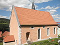
Church in Altenberga (south side)

War memorial (1914–18) below the church in Altenberga
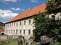
Former castle in Altenberga (2012)
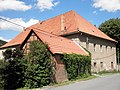
Former castle in Altenberga (2012)


societies
The local sports club Altenberga eV was active from 2012 to 2016. The club disbanded in 2016.
literature
- Hannelore Kuhn: Family book of the parish Altendorf. (Saale-Holzland district). 1641 to 1808. With the Altenberga branch and the villages of Dürrengleina (also called Gleina), Greuda, Schirnewitz and Schöps (= Central German local family books of the AMF. No. 5, ZDB -ID 2385367-0 ). Printed as a manuscript. Archive of the Working Group for Central German Family Research, Leipzig et al. 2000.
- Hans-Jürgen Haase: Altenberga. Burgrave seat, lordship, manor and community . Chronicle on the occasion of the 750th anniversary of the first documentary mention. Altenberga municipality, Stadtroda 2016.
Web links
Individual evidence
- ^ Population of the municipalities from the Thuringian State Office for Statistics ( help on this ).
- ^ Administrative community Südliches Saaletal: Altenberga community , accessed September 1, 2017
- ^ Wolfgang Kahl : First mention of Thuringian towns and villages. A manual. 5th, improved and considerably enlarged edition. Rockstuhl, Bad Langensalza 2010, ISBN 978-3-86777-202-0 , p. 11.
- ^ On-site display board (2012).
- ↑ Wilfried Warsitzka: The Thuringian Landgrave. Bussert & Stadeler, Jena 2004, ISBN 3-932906-22-5 , p. 304.
- ↑ Michael Köhler : Thuringian castles and fortified prehistoric and early historical living spaces. Jenzig-Verlag Köhler, Jena 2001, ISBN 3-910141-43-9 , p. 51 f.
- ↑ Thomas Bienert: Medieval castles in Thuringia. 430 castles, castle ruins and fortifications. Wartberg-Verlag, Gudensberg-Gleichen 2000, ISBN 3-86134-631-1 , p. 193 f.
- ^ Altenberga Castle.
- ^ Heinrich Bergner : Ring walls and castle ruins in the district of Kahla. In: Messages from the Association for History and Antiquity to Kahla and Roda. Vol. 6, 1908, ZDB -ID 514703-7 , pp. 25–36, here pp. 30–32 , (reprint, supplemented by Hansjürgen Müllerott: ring walls and castle ruins in the district of Kahla and the archeology and history of the Schauenforest, a résumé to the archaeological excursions 2004 and 2005. Thuringian Chronicle-Verlag HE Müllerott, Arnstadt 2012).
- ^ Jürgen Gruhle: Black Book of Land Reform - Thuringia. Internet, 2011.
- ↑ Alexander Schlotter: Announcement of the upcoming dissolution of the association on June 5, 2016. Accessed on January 31, 2018.
Albersdorf | Altenberga | Bad Klosterlausnitz | Bibra | Bobeck | Bremsnitz | Bucha | Bürgel | Crossing the Elster | Dornburg-Camburg | Eichenberg | Eineborn | Eisenberg | Frauenprießnitz | Outdoor orla | Geisenhain | Gneus | Golmsdorf | Gosen | Graitschen at Bürgel | Greater buckedra | Grosseutersdorf | Großlöbichau | Großpürschütz | Gumperda | Hainichen | Hainspitz | Hartmannsdorf | Heathland | Hermsdorf | Hummelshain | Jenalöbnitz | Kahla | Karlsdorf | Little buckedra | Kleinebersdorf | Kleineutersdorf | Laasdorf | Lehesten | Lindig | Lippersdorf-Erdmannsdorf | Löberschütz | Mertendorf | Meusebach | Milda | Möckern | Mörsdorf | Nausnitz | Neuengönna | Oberbodnitz | Orlamünde | Ottendorf | Petersberg | Poxdorf | Rattelsdorf | Rauda | Rauschwitz | Rausdorf | Reichenbach | Reinstädt | Renthendorf | Rothenstein | Ruttersdorf-Lotschen | Scheiditz | Schkölen | Grinding trips | Schlöben | Schöngleina | Schöps | Side rod | Serba | Silbitz | Stadtroda | St. Gangloff | Sulza | Tautenburg | Tautendorf | Tautenhain | Animal snail | Tissa | Trobnitz | Trockenborn-Wolfersdorf | Unterbodnitz | Waldeck | Walpernhain | Waltersdorf | Weissbach | Weißenborn | Wichmar | Rooms | Zollnitz