
Châteauneuf-de-Galaure
| Châteauneuf-de-Galaure | ||
|---|---|---|

|
|
|
| region | Auvergne-Rhône-Alpes | |
| Department | Drôme | |
| Arrondissement | Valence | |
| Canton | Drôme des collines | |
| Community association | Porte de DrômArdèche | |
| Coordinates | 45 ° 14 ′ N , 4 ° 57 ′ E | |
| height | 222-393 m | |
| surface | 18.08 km 2 | |
| Residents | 1,808 (January 1, 2017) | |
| Population density | 100 inhabitants / km 2 | |
| Post Code | 26330 | |
| INSEE code | 26083 | |
 View of Châteauneuf-de-Galaure |
||

Châteauneuf-de-Galaure is a French commune in the department of Drôme . Châteauneuf-de-Galaure is part of the arrondissement of Valence and the canton of Drôme des collines . The municipality has 1,808 inhabitants (as of January 1, 2017), who are called Castelneuvois .
geography
Châteauneuf-de-Galaure is located about 45 kilometers west of Grenoble on the Galaure . Châteauneuf-de-Galaure is surrounded by the neighboring communities of Saint-Sorlin-en-Valloire in the north, Hauterives in the northeast, Saint-Martin-d'Août in the east and southeast, Saint-Avit in the south, Mureils in the west and southwest and Anneyron in the West and northwest.
Population development
| year | 1911 | 1962 | 1968 | 1975 | 1982 | 1990 | 1999 | 2006 | 2013 |
|---|---|---|---|---|---|---|---|---|---|
| Residents | 1,233 | 1,182 | 1,153 | 1,153 | 1,252 | 1,246 | 1,276 | 1,481 | 1,752 |
Attractions
- Saint-Bonnet church, originally documented church construction around 880, rebuilt in the 10th century, removed and rebuilt in 1886
- 19th century church Saint-Jean
- Church of Charrière from the 15th / 16th centuries Century, formerly part of a Franciscan monastery
- Montchenu Castle
- Castle Rois
- Remnants of a donjon
- Merlière fort from the 16th century
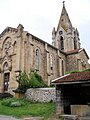
Saint-Bonnet church

Saint-Jean church

Charrière Church


Personalities
- Georges Finet (1898–1990), closest confidante of Marthe Robin and co-founder of the Foyers de Charité .
- Marthe Robin (1902–1981), mystic
Web links
Commons : Châteauneuf-de-Galaure - Collection of images, videos and audio files