
Mureils
| Mureils | ||
|---|---|---|
|
||
| region | Auvergne-Rhône-Alpes | |
| Department | Drôme | |
| Arrondissement | Valence | |
| Canton | Saint-Vallier | |
| Community association | Porte de DrômArdèche | |
| Coordinates | 45 ° 10 ′ N , 4 ° 50 ′ E | |
| height | 214–378 m | |
| surface | 5.45 km 2 | |
| Residents | 465 (January 1, 2017) | |
| Population density | 85 inhabitants / km 2 | |
| Post Code | 26240 | |
| INSEE code | 26219 | |
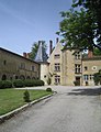
 View of Mureils |
||

Mureils is a French commune in the department of Drôme . Mureils belongs to the arrondissement of Valence and the canton of Saint-Vallier . The community has 465 inhabitants (as of January 1, 2017), who are called Mureillois .
geography
Mureils is located about 25 kilometers north-northeast of Valence an der Galaure . Mureils is surrounded by the neighboring communities of Anneyron in the north and northwest, Châteauneuf-de-Galaure in the east and northeast, Saint-Avit in the southeast, Claveyson in the south, La Motte-de-Galaure in the southwest and Fay-le-Clos in the west.
Population development
| year | 1911 | 1962 | 1968 | 1975 | 1982 | 1990 | 1999 | 2006 | 2013 |
|---|---|---|---|---|---|---|---|---|---|
| Residents | 395 | 290 | 246 | 244 | 234 | 272 | 307 | 340 | 442 |
Attractions
- Saint-Jean church
- La Bretonnière Castle
- Ruins of a keep
La Bretonnière Castle

Ruin of the donjon


Web links
Commons : Mureils - collection of images, videos and audio files