
Andancette
| Andancette | ||
|---|---|---|
.svg)
|
|
|
| region | Auvergne-Rhône-Alpes | |
| Department | Drôme | |
| Arrondissement | Valence | |
| Canton | Saint-Vallier | |
| Community association | Porte de DrômArdèche | |
| Coordinates | 45 ° 15 ′ N , 4 ° 48 ′ E | |
| height | 129-168 m | |
| surface | 5.98 km 2 | |
| Residents | 1,339 (January 1, 2017) | |
| Population density | 224 inhabitants / km 2 | |
| Post Code | 26140 | |
| INSEE code | 26009 | |
| Website | http://www.andancette.fr/ | |
 Town Hall (Mairie) of Andancette |
||

Andancette is a French commune in the department of Drôme . Andancette belongs to the arrondissement of Valence and the canton of Saint-Vallier . The municipality has 1,339 inhabitants (as of January 1, 2017), who are called Andancettois .
geography
Andancette is located about 35 kilometers north-north-west of Valence on the Rhône . Andancette is surrounded by the neighboring communities of Saint-Rambert-d'Albon in the north, Albon in the east, Beausemblant in the south-east, Laveyron in the south, Andance in the west and south-west, Saint-Désirat in the west and north-west and Champagne in the north-west. The Paris – Marseille railway runs through the municipality .
history
The parish was created in 1872.
Population development
| year | 1911 | 1962 | 1968 | 1975 | 1982 | 1990 | 1999 | 2006 | 2017 |
|---|---|---|---|---|---|---|---|---|---|
| Residents | 663 | 781 | 976 | 1,099 | 1,020 | 1,157 | 1,156 | 1,237 | 1,339 |
Attractions
- 19th century church of Saint André
- Marc-Seguin suspension bridge from 1827
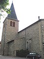
Saint-André church

Suspension bridge


Personalities
- Lucien-Marie Dorne (1914–2006), founder of the Missionary Family of Our Lady
Web links
Commons : Andancette - collection of images, videos and audio files