
Moras-en-Valloire
| Moras-en-Valloire | ||
|---|---|---|
|
||
| region | Auvergne-Rhône-Alpes | |
| Department | Drôme | |
| Arrondissement | Valence | |
| Canton | Drôme des collines | |
| Community association | Porte de DrômArdèche | |
| Coordinates | 45 ° 17 ′ N , 5 ° 0 ′ E | |
| height | 217-420 m | |
| surface | 8.58 km 2 | |
| Residents | 667 (January 1, 2017) | |
| Population density | 78 inhabitants / km 2 | |
| Post Code | 26210 | |
| INSEE code | 26213 | |
| Website | http://www.moras-en-valloire.fr/ | |
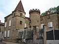
 View of Moras-en-Valloire |
||

Moras-en-Valloire is a French municipality with 667 inhabitants (as of January 1 2017) in the department of Drôme in the region Auvergne Rhône-Alpes ; it belongs to the arrondissement of Valence and the canton of Drôme des collines (until 2015: canton of Le Grand-Serre ).
geography
Moras-en-Valloire is located about 26 kilometers south-southeast of Vienne . Moras-en-Valloire is surrounded by the neighboring municipalities of Manthes in the north and northeast, Lens-Lestang in the east, Hauterives in the south and Saint-Sorlin-en-Valloire in the west.
Population development
| year | 1962 | 1968 | 1975 | 1982 | 1990 | 1999 | 2006 | 2017 |
| Residents | 458 | 475 | 387 | 468 | 582 | 602 | 604 | 667 |
| Sources: Cassini and INSEE | ||||||||
Attractions
- Notre-Dame-de-l'Assomption church
- historical town center
- House of the Marshal of Ornano ( Maison du Gouverneur ), built in 1592
- Maison Quarrée from the 16th century, today's town hall

Notre-Dame-de-l'Assomption church
Maison du Governor

Maison Quarrée, today's town hall


Personalities
- Maurice Savin (1894–1973), painter
- Lucien Rebatet (1903–1972), writer
Web links
Commons : Moras-en-Valloire - collection of images, videos and audio files