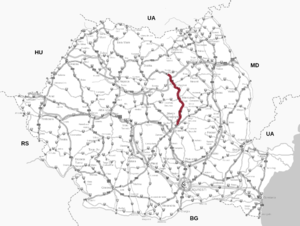
Drum national 12
| Drum național DN12 in Romania | |

|
|
| map | |
| Basic data | |
| Operator: | CNAIR |
| Start of the street: |
Chichiș ( 45 ° 47 ′ N , 25 ° 49 ′ E ) |
| End of street: |
Toplița ( 46 ° 56 ′ N , 25 ° 21 ′ E ) |
| Overall length: | 169.6 km |
|
Jewțe ( circles ): |
|
| Requirement for use: | Rovignette |
| The road north of Sfântu Gheorghe (2009) | |
|
Course of the road
|
|
The Drum naţional 12 ( Romanian for "National Road 12," short DN12 ) is a main road in Romania . The street also forms part of the European route 578 .
course
The road runs in a northerly direction parallel to the Olt river from Chichiș , where it branches off from Drum național 11 ( European route 574 ), via the district capital Sfântu Gheorghe where the Drum național 13E branches off to the east, and Băile Tuşnad , where the north near the village of Cozmeni Drum național 11B meets them in the district capital Miercurea-Ciuc (Szeklerburg), where the Drum național 12A branches off to the east and the Drum național 13A branches off to the west. From there, the road continues north via Sândominic and then north-west to Gheorgheni . There the drum național 13B goes to the west and the drum național 12C to the east. The road continues in a north-westerly direction to Toplița , where it meets and ends at Drum național 15 .
The length of the road is around 170 kilometers.
Web links
Individual evidence
- ↑ Information on national roads on the website of the Society for Road Infrastructure (CNAIR)
- ↑ România, Atlas rutier și turistic 1: 300,000, Budapest 2015, CARTOGRAPHIA Kft., ISBN 978-963-352-646-0 .

