
Forest (Eifel)
| coat of arms | Germany map | |
|---|---|---|
_COA.svg)
|
Coordinates: 50 ° 13 ' N , 7 ° 15' E |
|
| Basic data | ||
| State : | Rhineland-Palatinate | |
| County : | Cochem cell | |
| Association municipality : | Kaisersesch | |
| Height : | 272 m above sea level NHN | |
| Area : | 3.93 km 2 | |
| Residents: | 368 (Dec. 31, 2019) | |
| Population density : | 94 inhabitants per km 2 | |
| Postal code : | 56754 | |
| Area code : | 02672 | |
| License plate : | COC, ZEL | |
| Community key : | 07 1 35 031 | |
| LOCODE : | DE FEF | |
| Community structure: | 3 districts | |
| Association administration address: | Am Römerturm 2 56759 Kaisersesch |
|
| Website : | ||
| Mayoress : | Nicole Fuhrmann | |
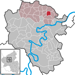
| Location of the local community Forst (Eifel) in the district of Cochem-Zell | ||
 _in_COC.svg) |
||

_001x.jpg)
,_Turm_der_alten_kath._Pfarrkirche_St._Castor_02.JPG)
Forst (Eifel) ( ) is a municipality in the district of Cochem-Zell in Rhineland-Palatinate . It has been a member of the Kaisersesch community since July 1, 2014 .
geography
The community is located in the East Eifel between Treis-Karden and Kaisersesch . It is divided into the districts of Forst, Molzig and Pfaffenhausen. The community also includes the Birkenhof, Kapellenhof and Pfaffenhausermühle residential areas .
history
In two papal documents from 1178 and 1186 the place is called "Vosca" and "Vostra". Forst was the center of the Nasser or Forster parish , which has been an early parish and judicial district since the Middle Ages. Around 1790 the landlords were, in addition to the St. Kastor monastery in Karden, the Freiherrn von Clodt, the Counts von der Leyen, the Counts Waldbott von Bassenheim, the Rosenthal Monastery and the Franciscan Monastery in Karden.
Until the end of the 18th century, Forst belonged to the Electorate of Trier and was assigned to the administration and jurisdiction of the Münstermaifeld office.
In 1794 the Left Bank of the Rhine was occupied by French revolutionary troops in the First Coalition War. From 1798 to 1814, Forst belonged to the canton of Münstermaifeld in the Rhine-Moselle department . Around 1802, the church and monastery property were secularized and confiscated from the French state .
At the Congress of Vienna (1815), the region came to the Kingdom of Prussia , Forst was assigned to the newly established district of Cochem in the administrative district of Trier in 1816 and administered by the Karden mayor .
After the Second World War , the municipality of Forst within the French occupation zone became part of the then newly formed state of Rhineland-Palatinate.
The community has had the addition of "(Eifel)" to its name since June 1, 1970.
- Population development
The development of the population of Forst (Eifel), the values from 1888 to 1988 are based on censuses:
|
|
politics
Municipal council
The council in forestry consists of eight council members, who in the local elections on May 26, 2019 in a majority vote were elected, and the volunteer local mayor as chairman.
coat of arms
The municipality has had a coat of arms since 1987 :
|
|
Blazon : “Shield divided in the Göpel cut. In front a stylized black temple in silver, behind in green a silver church, below in gold over three red diamonds four red balls, each in bars " |
| Justification of the coat of arms: The three-part coat of arms indicates the districts of Forst, Molzig and Pfaffenhausen in the municipality. The temple complex is reminiscent of the Roman settlement in the “Stockborn” corridor. The center of the Nasser parish of nine courtyards was the old church, which is mentioned in 1288 in the will of Rudolf von Polch. The seal of the Nasser parish from 1587 shows, among other things, the coat of arms of Brunsperch-Brohl, which is placed in the lower part of the coat of arms. For many years they had the Pellenzgericht as a fief. |
Personalities
- Johann von Forst (≈1405–1452), Benedictine and abbot of the abbeys of St. Matthias and St. Maximin in Trier, as well as the abbey of St. Pantaleon in Cologne
See also
Web links
- Local community of Forst (Eifel)
- Literature about forest in the Rhineland-Palatinate state bibliography
Individual evidence
- ↑ State Statistical Office of Rhineland-Palatinate - population status 2019, districts, communities, association communities ( help on this ).
- ↑ State Statistical Office Rhineland-Palatinate (ed.): Official directory of the municipalities and parts of the municipality. Status: January 2019 [ Version 2020 is available. ] . S. 34 (PDF; 3 MB).
- ↑ Official municipality directory (= State Statistical Office of Rhineland-Palatinate [Hrsg.]: Statistical volumes . Volume 407 ). Bad Ems February 2016, p. 187 (PDF; 2.8 MB).
- ↑ State Statistical Office Rhineland-Palatinate: My village, my city. Retrieved October 30, 2019 .
- ^ The Regional Returning Officer Rhineland-Palatinate: Local elections 2019, city and municipal council elections
- ^ Alfons Friderichs: Book of arms of the Cochem-Zell district. Self-published, Zell / Mosel 2001, ISBN 3-00-008064-3 , p. 106 f.

Alf | Alflen | Altlay | Alt-trimmed | Auderath | Bad Bertrich | Beilstein | Beuren | Binningen | Blankenrath | Brachtendorf | Bremm | Briedel | Brieden | Briedern | Brohl | Bruttig-Fankel | Büchel | Bullay | Cochem | Dohr | Durfus | Düngenheim | Ediger-Eller | Ellenz-Poltersdorf | Eppenberg | Serious | Eulgem | Faid | Felt | Forst (Eifel) | Forst (Hunsrück) | Gamling | Gevenich | Gillenbeuren | Greimersburg | Grenderich | Hambuch | Haserich | Hauroth | Hesweiler | Illerich | Kaifenheim | Kail | Kaisersesch | Kalenborn | Kliding | Klotten | Country core | Laubach | Leienkaul | Lie | Liesenich | Lütz | Lutzerath | Masburg | Mesenich | Medium- bodied | Möntenich | Moritzheim | Mosel core | Tired (Moselle) | Müllenbach | Neef | Nehren | Panzweiler | Peterswald -öffelscheid | Pomerania | Pünderich | Reidenhausen | Roes | Sankt Aldegund | Showers | Schmitt | Senheim | Sosberg | Tellig | Treis cards | Elms | Urmersbach | Urschmitt | Valwig | Wagenhausen | Walhausen | Hamlet | Wirfus | Wollmerath | Zell (Mosel) | Zettingen