
History of Wales
The history of Wales in the sense of the human history there can be traced back about 230,000 years, but the subsequent cold ages with their enormous glacier masses interrupted human settlement several times.
prehistory


One of the first survey works on the written history of Wales, published in 1925, was by Mortimer Wheeler . In 1965 I. Ll. Foster and Glyn Daniel made their Prehistoric and Early Wales , in turn, in 2000, Prehistoric Wales was delivered by Frances Lynch, Stephen Aldhouse-Green and JL Davies. The long familiar separation between written and written history was increasingly viewed as a mere difference in the source location and the related methodology, especially since, as John Davies put it in his 2005 History of Wales : 'To begin with history and to ignore the previous history means to lose sight of the basic fact that by the time the people of Wales took the stage in history, every development of importance had already taken place '. Accordingly, they had all the 'cultural, spiritual and social attributes of being human', and all technological skills that dominated until the 18th century had long been available to them. The extremely small difference for another millennium consisted in the fact that no one had been able to write anything before the turn of the century, while after that the written sources were extremely scarce and fragmentary until the High Middle Ages .
Middle Paleolithic, Neanderthals (around 230,000, again from 70,000 before today)
The earliest archaeological finds from Wales are from the Middle Paleolithic . It is about 19 teeth of Neanderthals that were discovered during excavations from 1978 to 1995 in the Pontnewydd Cave (also Bontnewydd) in the north of the country, more precisely in the Elwy Valley in Denbighshire . They also represent the northernmost human remains of the Neanderthal man. The teeth can be assigned to six individuals, which were dated to an age of around 230,000 years. They belonged to both children and adults. Animal bones with traces of cuts were also discovered in the cave. These earliest inhabitants must have belonged to a group with a tail stretching as far as the Netherlands , as Great Britain was not an island at the time.
In the associated glacial period , ice masses up to 300 m thick covered most of the British Isles during the maximum expansion of the glaciers , so that human traces can only be expected in the subsequent period between 125,000 and 70,000 before today, namely from later or "classical" “Neanderthals. At the time of maximum glaciation, these are likely to have visited Wales for hunting at best seasonally. Some stays of Neanderthals can be proven in the cave of Coygan (two hand axes ) near Laugharne in Carmarthenshire , in the southwest of Wales. Around 70,000 BC The last glacial period began, but it ended around 59,000 and 37,000 BC. Chr. Was interrupted by warmer phases. During this time, Neanderthals probably lived in the caves of Pontnewydd and Ffynnon Beuno in Denbighshire, the said Cave of Coygan - in this now destroyed cave the artifacts were dated to an age of 64,000 to 38,000 years - as well as Paviland on the Gower Peninsula . These are assigned to the Moustérien . The people hunted mammoths, woolly rhinos, horses and spotted hyenas in a dry grassy landscape.
Upper Paleolithic, anatomically modern man (35,000 - 20,000 BC, finally from approx. 10,000 BC)

Around 2006, around 20 Upper Paleolithic sites were known in Wales, half of which were split between the early and late Upper Paleolithic; In contrast, the number of sites in Great Britain rose from 40 to 60 in total. Tools from around 26,000 BC were found again in the caves of Ffynnon Beuno and Paviland. Chr.
The most famous individual find is probably the Red Lady of Paviland from the Paviland caves. Believed to be a woman by the discoverer, William Buckland , in 1823, the skeleton is now identified as a young man who was dated 33,000 years ago using radiocarbon dating. The find was accompanied by the bones of cold-loving animals such as cave bears ( Ursus arctos ), reindeer ( Rangifer tarandus ) and woolly rhinoceros ( Coleodonta antiquitatis ) and therefore probably originates from the Denekamp warm period of the Weichselian ice age , the archaeological epoch of Aurignacien II he was ritually buried.

During the last peak of the Ice Age around 22,000 years ago, Wales was believed to have been uninhabited; it is assumed that the continent will be repopulated. Hoyle's Mouth Cave in Pembrokeshire , with numerous back knife finds and other flint artifacts, is already an example of the epipalaeolitic settlement. From the period around 12,000 to 10,000 BC The 15 by 11 cm, barely recognizable incised drawing of a reindeer , which was discovered in a cave on the Gower Peninsula near the south coast of Wales in 2010, is the oldest rock art in Great Britain. In the time around 11,500 BC. A horse's jaw covered with zigzag lines, which had been worked with a flint tool, could be dated. The work is considered the oldest evidence of "decorative art" in Wales, for ornamental art.
These works already belong to the Creswellia , which dates from 12,800 to 12,000 BC. Chr. Existed, an archaeological culture that emerged on the one hand from the Magdalenian , on the other hand it had close relationships with the Hamburg culture . Since Great Britain was still connected to the European mainland at that time, and Doggerland still existed and the later North Sea connected Central Europe with Britain, this relationship is obvious. Accordingly, the Creswellian culture followed the penknife point complex , (up to 10,700 v. Chr.) The spring diameter culture . The Creswellia - the term was coined by Dorothy Garrod in 1926 - is named after Creswell Crags , a site in Derbyshire . It is only detectable in southern Wales, where Paviland is an important site. There are also other sites in Pembrokeshire, including Nanna's Cave on Caldey Island . The hunted prey were Rhinoceros tichorinus and reindeer, plus a few references to the hunting of mammoths . This arctic world may have ended with warming at the end of the last glacial period ; While the members of the Creswellia culture lived on a tundra, the environment of the penknife people increasingly forested, which drastically changed the way of life, as well as fauna and flora. Another cooling that occurred from 10,730–9,700 BC. Lasted and affected all of Central and Northern Europe, the Younger Dryas period represented, a nearly millennium in which the tundra spread more strongly again.
Mesolithic (approx. 8500 to 4500 BC)
The retreat of the glaciers began around 10,000 BC. A to 8300 BC BC Wales was ice-free. The temperature rose to around 3000 BC. Chr. The hunters, fishermen and gatherers lived in a completely different environment and had to adapt accordingly. Great Britain became an island, forest replaced the grasslands, so that the herds that had previously grazed there also disappeared. Around 5500 BC BC was all of Wales, apart from the sand dunes and the areas beyond 750 m height, consisted of forest. The grassland dwellers reindeer, mammoth and bison disappeared, the forest dwellers deer and stag as well as wild boar became the preferred prey. This led to a far-reaching change in the entire lifestyle, which was no longer based on large herds. The last Mesolithic finds of human remains from Wales date back to around 5000 BC. BC, the earliest Neolithic dates back to around 3150 BC. BC, although the region was already settled earlier. Important localities are Prestatyn, Aberystwyth , Burry Holmes (Gower) and The Nab Head (Pembrokeshire).
For the hunt for the mostly smaller forest dwellers, after the retreat of the glaciers and the forestation of the land, new weapons and hunting techniques were developed, the same applied to fishing. However, areas were probably also created by means of fire, in which one could keep herds. At least now the dog was used. Finds from the Mesolithic are more numerous, particularly on the coast (e.g. Prestatyn in North Wales). A new research project is the excavation on Caldey Island in Pembrokeshire , South Wales , which is attempting to determine dietary shifts through isotope analysis. Although the number of sites remained small, the stays of groups for specific purposes can be verified at so-called "task sites". There were places where tools were made, such as The Nab Head on St Brides Bay in Pembrokeshire (around 8500 BC), as well as those where pearls were made, which were considered status indicators and possibly in a long-distance trade flowed in. In 2010, the oldest Mesolithic house on the British Isles was found in Star Carr , North Yorkshire . It originated around 9000 BC. BC, was inhabited for maybe 500 years. The 3.5 m wide house was spanned by a roof that rested on a circle of wooden posts. In addition, oars, pearls, arrowheads and headdresses made of antlers were found, which indicates a ritualization. At Trwyn Du on Anglesey, more than 5000 flint artifacts and two stone axes were found under a Bronze Age burial mound. The coastal site, which is now threatened by erosion, was located on a river at that time and was visited seasonally. The first evidence of composite tools , the parts of which were glued to one another, is a flint point that was found in Burry Holms, Gower / Gŵyr , and on which birch pitch , a type of glue, was found.
Neolithic (from the beginning of the 4th millennium to around 2000 BC)

A far more drastic change in living conditions was the replacement of the hunter, gatherer and fishing cultures with rural immigration, although the coastal inhabitants probably stuck to their way of life for longer, provided it was based on seafood (see Nanna's Cave ). The process known as Neolithization , which led to pastoral and peasant cultures, began in Wales in the 4th millennium BC. BC, probably by rural immigrants from France. There are two settlement centers in Wales, namely in the north on Anglesey and in Caernarvonshire , in the south in Pembrokeshire . In addition, there are smaller settlement concentrations along the northern and southern coastline, but also at the foot of the Ardudwy on the coast of Merionethshire in the north.
The first settlers did not build megalithic structures yet, but when around 3500 BC. After the cultivation of the soil in the Vale of Glamorgan , in Pembrokeshire and in the Usk valley , but also in Anglesey, the so-called Cromlechi emerged , like the Gwernvale Cromlech in the Usk valley that was created at that time . Around 3200 BC Barclodiad y Gawres originated on Anglesey. The extensive work required for this indicates that larger communities were behind these structures. It was estimated that at least 200 men must have worked on the Vale of Glamorgan. Here there are close structural similarities with Ireland, while the Cromlechi of Glamorgan and Breconshire, but also of Capel Gannon in the Conwy Valley, which belong to the Severn-Cotswold Group , were strongly influenced by Brittany . It is assumed that although larger groups came together to build such a religiously motivated complex, at or in which the dead were buried, they then belonged to smaller groups who lived in the vicinity and, depending on the leaching of the soil, their settlement within a territory Relocated every few years. The only fixed place was the respective Cromlech, with cattle breeding predominating over agriculture. Beef was probably preferred for meat , but sheep , pork and goat were also consumed; however, hunting was insignificant among the Neolithic. In Windmill Hill emmer dominated the grain with 90%. The larger henges , more or less round areas with a diameter of 20 to 480 m, which were bordered by an earth wall, often with trenches on the inside, served as places for trade, ritual and gathering . Llandygai was built between 3650 and 3390 BC. BC, making it one of the oldest structures of this type.
The outstanding material of the era was wood, but a number of tools, in particular the hatchet, were only now in use everywhere to work it. With Graig Lwyd on the Penmaenmawr arose around 3000 BC. One of the early mines to extract the necessary raw material. Axes from the pits there can be found almost everywhere in Britain, so that one can speak of a trading system, systems like those found in mainland Europe. Unadorned pottery was found in Anglesey and Pembrokeshire, probably locally produced. However, ceramics were also introduced in the later Neolithic.
In striking contrast to the effort that has been made for ritual purposes is the fact that the settlements in Wales consist of only a few, small houses. Excavations took place in Clegyr-Boia near St David's, then Cefn Mabwnws , Breconshire and Mount Pleasant, finally Glamorgan , where excavations revealed a stone house measuring 5.7 by 3.3 m, with the post holes for a stand, who had a thatched or thatched roof.
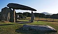
While there are hardly any causewayed camps and henge monuments compared to England, there is an impressive legacy from the Neolithic Age in around 40 alignments , various menhirs and over 150 preserved megalithic structures , especially in Caernarvonshire and Anglesey (around 23 each) and in Pembrokeshire (around 40). About 50 systems are located in long hills, the rest are round (probably older, as they were built over) or other shapes. Some of the sites have familiar names and have been explored and described several times over the past 200 years. These include Bryn Celli Ddu , Capel Garmon , Ffostill North, Gwernvale , Nicholaston, Parc Cwm , Pen y Wyrlod II, Pentre Ifan , Tinkinswood , Ty Illtyd and Ty Isaf . But only the most recently investigated sites ( Dyffryn Ardudwy and Gwernvale) have produced acceptable conclusions about the history of the facilities. The organic remains of the early Neolithic are sparse, but in Gwernvale in Powys (on the outskirts of Crickhowell) the remains of a wooden structure have been discovered in front of the stone grave.
- Megalithic systems

Carreg Samson , Pembrokeshire

Llech-Y-Tripedd , Pembrokeshire

Trellyffaint , Pembrokeshire
Pentre Ifan , Pembrokeshire

Tinkinswood , Glamorgan


Towards the end of this era, the area around Stonehenge played a role of surprising radiance for the whole of Britain . The complex served as a burial place for apparently important people from England, Wales and Scotland. The bluestones, the oldest stones in Stonehenge, came from around 3000 BC. From south west Wales. They apparently served to mark the very important grave sites. In Durrington Walls , the largest Neolithic settlement in Britain, near Stonehenge, people gathered from around 2500 BC. The builders of the monument probably at the winter solstice and celebrated extensive celebrations there, during which pork was mainly consumed. Visitors came from all areas of the island, including eastern Scotland, but a significant proportion of the bones found at Stonehenge came from people who had lived in Wales.
Bronze and Iron Ages, Celts (from 2500/2000 BC)

The Bronze Age in Wales lasted from around 2500 to 750 BC at the earliest. BC, whereby the bell beaker culture (up to 1400 BC) is counted as early as the Bronze Age, while in continental chronology it is assigned to the end of the Neolithic. The first metal objects, initially made of copper, appear around 2500 BC. BC, then made of bronze, but bronze was not in general use until around 1400 BC. Now wool was woven, the wheel was taken over, oxen harnessed to the plow, and how livestock farming continued to prevail over soil cultivation. From around 2000 BC BC the dead were buried in individual graves, the grave goods, especially in the form of vessels, became much richer. This change is attributed to the aforementioned bell beaker culture, which was believed to belong to immigrants from the Rhine estuary, whose culture in turn showed numerous elements of the steppe cultures. Then again one preferred the change of culture out of itself as an explanatory model. The members of the new culture wore battle axes, bronze knives and daggers, as well as bows and arrows, they knew beer and they worked gold. Now extensive power structures arose around the metal centers under the leadership of a powerful aristocracy or priesthood. This was also reflected structurally, for example in Silbury Hill in Wiltshire , a little southeast of Wales, or in Stonehenge , 30 km away , which may have belonged to the same political system.
The cultivation of small fields, which gave rise to the talk of gardening, was replaced by large areas, as could be demonstrated at Penmon on Anglesey. One of the fields measured 90 * 40 m. Wheat, rye and flax grew there, and the soil was loosened with light plows, as can be demonstrated on the Penmaenmawr. The small number of settlements could indicate that semi-nomadic pastoralism continued to prevail. At the same time, the comparatively mild climate also made it possible to use higher areas. One third of the Caernarfonshire graves from the Early Bronze Age are more than 400 m above sea level.
According to John Davies (2007), over 50 stone circles were created during this period , which make up about 5% of their total number in Great Britain. This contrasts with the enormous number of graves, which number around 400 in Glamorgan alone . Triangular and square stone enclosures were added to the stone circles. The Welsh circles, including that of Penmaenmawr in Caernarvonshire (Griffiths 1960; Lynch 1995), are almost all Bronze Age. The population cannot be approximated either; it ranges from a few thousand to the same population that Wales did not reach until around AD 1100. Overall, Wessex and Ireland alike exerted significant cultural influence.

After 1400 BC The Uplands, the higher-lying areas, had to be given up due to a significant cooling. The original landscape was changed so much that it never again reached the state before human use, not even in the areas that are today considered "untouched". The previously relatively uniform cultural area of Wales now disintegrated into the coastal fringes and the higher areas, where ceramics were no longer in use. This indicates a renomination, because vessels made of wood, leather or metal are more suitable for moving groups than those made of fragile and heavy material. Bell beakers, cairns and stone circles significantly reduced their number, but the number of tools, weapons and bronze jewelry increased sharply. In addition, there were occasionally gold works, such as the lumula from Llanllyfni, the Moel-Siabod-Schild or the Nannau-Schildbuckel, which are, however, considered imported products. Around 1000 BC The mining of copper increased sharply, and domestic production also increased significantly. As a result, real schools emerged, recognizable by the bronze axes. From the now very frequent weapons finds, it was concluded that a more restless, warlike society, which also includes the hilltop castles, which were built over a millennium. This is how Dinorbs originated around 1000 BC. BC as one of the oldest fortifications of this kind. These systems were concentrated in the southwest of Wales, where the Demetae later lived. But especially with them there were only small family forts, so that there was apparently no overarching authority. Climatic deterioration, the resulting dispute over land or a growing population are seen as possible causes for the now more frequent fighting. As a result, around 600 hilltop castles were built in Wales alone, as John Davies noted in 2006. Their area ranged from a single fortified courtyard to an area of more than 6 hectares. 22 alone cover more than 6 hectares. Even at that time, the country's economy was able to feed quasi-urban structures, but the territorial principle finally prevailed. Nomadism largely disappeared and a more hierarchical society emerged.
Whether the Celts actually immigrated from continental Europe in several waves at the beginning of the Iron Age (750 BC to 48 AD) , as was the accepted doctrine until the end of the 1960s, is highly doubted today. Myles Dillon argued that the bell- beaker people brought the Celtic language and culture to the British Isles at a time when the Aryans were migrating eastward to India. This explains the similarities between the westernmost and the easternmost representatives of the Indo-European cultures . The differences between the Celtic of Ireland and the British ( P and Q Celtic ) would then be explained by the duration of the spatially separated settlement. Today, Celtic is often seen as a universal language of traders that has established itself across cultural borders; therefore no migration is needed as an explanation, but an acculturation process.

One of the largest structural structures of the Iron Age is the settlement of Tre'r Ceyri (also Ceiri) at the foot of the Yr Eifl. The castle was surrounded by a ring wall in which around 150 houses can be verified. The settlement originated around 200 BC. BC, it existed until Roman times. Shepherds probably lived there in the summer in simple huts at an altitude of about 400 m. The hilltop castles now reached completely different dimensions. Llanymynech extends over 57 hectares. Its existence probably goes back to the copper sites in the area. This fortress and the grounds of Breiddin, Ffridd Faldwyn and Oswestry Old Fort are possibly a kind of border fort of the Ordovices or the Cornovii , who lived mainly in the central Severn Valley . Some of the forts received around 200 BC. A second ring moat. When the Belgae ruled the south of England, there were additional towers, guard rooms and complicated entrances.
In contrast, nothing comparable emerged in the south of Wales. Defensive structures were built there on cliffs, only Dunraven has so far had a larger number of houses in the interior, namely 21. This is where the Silures lived , who offered the most fierce resistance to the Romans. The oldest iron artifact in Wales was found on their territory, namely at Llyn Fawr, where an iron sword was found in 1908, dating from around 600 BC. Was made. The sword belongs to the Hallstatt culture . The helmet (or hanging pot) from Cerrigydrudion already belonged to the subsequent La Tène culture . BC originated. This culture had an emphasis on Anglesey, where more than half of its artifacts were found. It turns out that the horse played a central role in this culture. In addition, the island was the core area of the Druidic culture of Britain between 150 BC. The earliest written record shows that in southern Great Britain, Brythonic , a Celtic language, was spoken by the ruling classes at that time .
Coin finds in Wales document several minor kingdoms during the Iron Age. The Deceangli sat in the northeast, the Ordovizians in the northwest, the Demeter in the southwest and Silurians in the southeast and the Cornovii in the border area with England. Wales was almost entirely ceramic during the Iron Age, but there are rich finds of metal objects. Of these tribes, the south-east Silurians and the Ordovices in central and north-west Wales were the largest and most powerful. They also offered the greatest resistance to the advance of the Roman invaders into Wales.
Roman conquest (from 48 AD), Romanization, Christianization


Looking at Caesar's landings on the south coast of England in 55 and 54 BC, As well as Caligula's ambitions in AD 39, the island did not come into the sight of the Roman conquerors until almost a century after the conquest of Gaul. In that century the Belgae stabilized an empire in the southeast. Around 30 AD, Cunobelinus , as the Romans called him (while he is called Cynfelyn in Welsh tradition), from the Catuvellauni tribe, ruled the area between Essex and Surrey . Against this new power, elevated castles were built in Wales. When Cunobelinus died around AD 40, he was followed by his two sons Caratacus and Togodumnus , while another son named Amminius hoped to get his share of the inheritance with the help of the Romans. Thus Rome embarked on a new conquest, this time directed against a country in which from now on about every tenth legion was regularly stationed, whereas it only made up a thirtieth of the area. The border of the empire was again extended. In May 43, a fleet led by Aulus Plautius with 40,000 men sailed across the canal. In 47, when the governor's term of office ended, the southeast of the island was conquered, the border between Lincoln and Exeter . Some tribes viewed their new neighbors as invaders, especially the Silures in south-east Wales, to which Caratacus (in Welsh lore Caradog) had fled. The Brigantes living in Central England , allies of Rome, soon also developed resentment against the Romans, perhaps encouraged by druids from Anglesey. By occupying the lower-lying areas, the Lowlands, which stretched between the tribal areas, Rome tried to isolate the tribes. Aulus Plautius accepted the submission of the Deceangli in 48 . With this, Wales appears for the first time - with Tacitus - in a written source.
The Legate Publius Ostorius Scapula began the first Roman attack in 48. The struggle against the Silurians and Ordovicen, however, would last for several years. The Romans built a camp for the XX near the place where Gloucester was later built. Legion, plus smaller camps in Usk , Clyro and other places. When the Silurians were defeated in a battle, Caratacus moved to the territory of the Ordovices, where he was captured in 51 AD and defeated by Scapula's troops. Nevertheless, he was able to escape once more - his family fell into the hands of the Romans. He fled to the Brigantes in the north, whose queen Cartimandua , however, handed him over to the Romans. Caratacus was abducted to Rome, where his dignified demeanor made such an impression on the Roman people that his life was spared.


The Silures had not yet given up and started a guerrilla war against the Romans. Scapula died during the campaign without having finally subjugated it. After his death they even won a victory against the Legio II Augusta (?). Under the governorship of Caius Suetonius Paulinus there were no further attempts to extend Roman rule to all of Wales, instead he marched north in AD 60 or 61 and occupied the island of Anglesey (Mona), their great druid sanctuary which is a center of the Resistance against the Romans was destroyed in the process. The druids there were killed and the sacred forests burned down. However, as a result of the uprising of the southeastern tribes under Boudica , which was very dangerous for Roman rule , in the course of which Londinium was burned down, he had to break off his campaign and hurriedly return to the southeast to put down the rebellion. As in numerous other cases, Rome responded with massacres and deportations. The Silurians were only finally defeated in 78 through several campaigns carried out by Sextus Julius Frontinus on behalf of Emperor Vespasian , who himself had served under Aulus Plautius. His successor Gnaeus Iulius Agricola finally subjugated the Ordovices and reoccupied Anglesey at the beginning of the following year. The XX. Legion from 67 to 84 in Viroconium near Shrewsbury (then the camp was abandoned), further camps were built for the second legion (Adiutrix) on the banks of the Dee near Deva (Chester) and for the Legio II Augusta on the banks of the Usk near Isca Silurum ( Caerleon). Rome carried out at least 13 campaigns between 48 and 79, at times perhaps 30,000 legionaries were deployed. At least 20 camps were created in Wales alone. Archaeological research unearthed at least 35 relief camps. The lack of military structures in southwest Wales gave rise to speculation as to whether the Demetae would have offered little resistance to the Romans. But in 2005 a 9 hectare warehouse was discovered in Dinefwr Park near Llandeilo . After the end of the fighting, the number of stationed legionaries was reduced, the twentieth legion was concerned with the construction of Hadrian's Wall on the Scottish border from 120 for a long time , from 143 many Welsh legionaries were active on the Antonine Wall .
The Romans now controlled most of Wales and built numerous roads to secure their rule and exploited natural resources, traded and integrated the economy into their extensive trading network. It was now part of the province of Britannia Superior , from late antiquity the Britannia Prima , which included the whole of western Britain. Apart from gold mining in Wales , there was little interest in this rugged and mountainous part of Britain as there was little fertile farmland. Most of the Roman remains still visible in Wales are military in nature. The country was largely ruled by the legionary camps in Deva (Chester) and Isca (Caerleon), which were connected by well-developed roads to the large auxiliary camps of Segontium and Moridunum (Carmarthen). The Romans only founded one larger city here, Venta Silurum (Caerwent), and the Moridunum fort was later converted into a civilian settlement.
The emergence of villae , which were only built in safe areas, indicates that there were economic concentrations around Caermarthen, in which servants or slaves did the work. These extensive houses represented the center of extensive land ownership. These production centers were strongly promoted by the army's demand for grain and, above all, Mediterranean products. It is possible that apples came to Wales, as well as oats, carrots, beets, parsnips, leeks, cherries, vines, walnuts or chestnuts. The westernmost villa in Britain was in Abercyfar, near Carmarthen; a total of about twelve more of the total of around 700 villas in Great Britain were found in Wales. The best known is probably Llantwit Major. The druid religion became through numerous Roman cults, including that of Mithras, which can be attested in Caernarfon and Carleon. The inhabitants tried equivalents for their Celtic gods in the Roman world of gods. So a temple of Mars-Ocelus was built in Caerwent. 367 was built in Lydney on the opposite side of the Wye from Caerwent. It was a temple for Nodens, the god of healing, so the complex was later called “a kind of Lourdes”, a pilgrimage site for the sick who hoped to find healing there. But for two generations already, all statements of the older religions in favor of Christianity, which 394 became the Roman state religion, disappeared.
_reverse.jpg)
By Magnus Maximus (383-388) is alleged that he was responsible for the withdrawal of a large part of the Roman troops from Wales, 20 years before Britain was 410 abandoned by the Romans and left to themselves. As a result, the attacks by Irish pirates increased, so that the forts finally had to be abandoned because they could no longer be defended. In the Welsh epic Mabinogion , Maximus appears as Macsen Wledig , married to Elen Luyddawg , the daughter of a clan leader from the Segontium region . This story is probably just a legend, but there is some evidence that it has a historical core.
The official seats of the bishops became the core of the administration and the exercise of political power. But only a few Roman official terms penetrated the Welsh language. Probably 213 or a decade earlier Britain was divided into two provinces, with Wales presumably becoming part of Britannia Superior . The trigger was possibly the revolt of Clodius Albinus , who had reached for the imperial diadem in 196. Probably under Constantius the island was divided into four provinces, Wales now belonged to Britannia Prima with the capital Cirencester. Despite the various attempts at usurpation, Britain's economy flourished in the period between 250 and 350. The island's grain yield was still sufficient for 361 to support Caesar Iulianus . But in the north the Antonine Wall had to be abandoned in 211, and around 300 there was a Dux Britanniarum in York . At the same time, the threat from the Irish Sea increased around this time, as the coasts were now reinforced. During this time, settlers from Ireland settled in the north-west and south-west of Wales. Dangers were also seen from the southern mainland, so that a Comes Litus Saxonicum was responsible there for protection against the 'Saxon coast'. Apparently the economy suffered, the population shifted or declined, as in Viroconium near the eastern border of Wales, where the local cathedral was abandoned around 350. When Stilicho saw the core of the Western Roman Empire threatened, 401 troops were withdrawn from Britain, and in 405 the west coast of Wales was sacked by a pirate named Nial. Three usurpers alone tried to become emperor in the next few years, so that more troops were withdrawn into the empire. Constantinus was killed in 411 while marching on Rome. As the historian Procopius later explained, ... from this time Britain remained under the rule of tyrants (i.e., probably usurpers). Emperor Honorius instructed the British, who were now defenseless, to do everything possible to defend them.
Anglo-Saxon conquest of England, principalities, attempts at unification (5th to 11th centuries)
As a result of the migration of Germanic gentes (gens, gentis = gender, species, people) to the west, maintaining Roman power in Britain became increasingly difficult. In addition to a general weakening, perhaps the arrival of the Angles and Saxons in Britain caused the withdrawal of the last legions in 410. Perhaps the withdrawal of the Romans also caused the arrival of the Angles, Saxons and Jutes. While some scholars assume that the Anglo-Saxons arrived in Britain around 380 - initially at the invitation of the Romans - the majority of historians assume that this happened around 440.
Small empires influenced by the Romans fought for supremacy in eastern Britain with the Angles and Saxons, while Wales was left to its own devices. As a result, Wales was cut off from its Celtic neighbors in Scotland and Cornwall , even if traces of Roman civilization were preserved for a long time - Latin inscriptions were still used in the 6th century, which correctly dated Consuls . In 2016, more than 570 inscriptions from the Early Middle Ages were known from Wales and the surrounding areas . In addition, archaeological finds now even testify to direct sea trade with the Mediterranean.

The oldest known author Gildas († 570) laments the inadequate adherence to Christian principles. Monasticism becomes tangible during this time, especially in the south-east ( Llancarfan ) and south-west (Menevia, St. David's). His influence reached as far as Ireland. The names of about 35 monasteries have been passed down, which were probably connected to one another in federations. Whether the Welsh language was written soon after 600 is controversial. The first inscription that offers more than name is the Towyn inscription (around 800); oldest Welsh glosses date from the middle of the 9th century. The church organization went its own way. There were married priests, but above all there were bishops who had no fixed territories.
With the Norman conquest of England, St. David's gained a considerable appreciation in the far west, because William the Conqueror himself made a pilgrimage to his cathedral in 1081. He was also canonized shortly after 1115. Two pilgrimages there counted as much as one pilgrimage to Rome.

Important sources are the 149 documents in Welsh and Latin in the Book of Llandaff , which date from the 7th to 9th centuries. Political poetry is only passed down from the 13th century (Canu Aneirin, Canu Taliesin, Stanzas of the Grave, Gododdin ). The oldest chronicles are the Annales Cambriae , plus genealogies from the 10th century. Four kingdoms are known in the 6th century, namely Gwynedd, Powys, Dyfed and Gwent, with all but Gwent existing until the end of the 12th century. Hywel Dda ('the good', † 950) temporarily united Gwynedd and Dyfed. It is disputed whether the record of Welsh law is attributable to him.
Wales was divided into a large number of partly Irish small kingdoms of the Déisi , so that a considerable number of Ogam stones can be found in Wales. It appears that fortifications were built against the Irish, such as Dinas Powys and Dinas Emrys near Cardiff and Snowdon.
There were hardly any rulers who ruled the whole country; the first was apparently Rhodri Mawr during the 9th century. Nevertheless, the country was consistently perceived as a unit, which is reflected in the name Cambria ( Cymru ) for the country and Cambrenses (New Welsh Cymnry, common inhabitants ) for the population. The residents were also referred to as Britones , while Wales or Welsh is an English foreign name that appears in Giraldus Cambrensis . Nevertheless, this foreign name became part of the princely title in the 13th century, for example in the form of princeps Wallie . Welsh law, on the one hand, marked this conception of national unity, but also consolidated it.
Rhodri's grandson, Hywel ap Cadell, nicknamed 'The Good', died in 950. After decades of instability that followed Howell's death, Gruffydd ap Llywelyn managed to unite much of Wales from 1039 to 1055. In the fight against Harold of Wessex, Wales lost with him in 1063 its most powerful ruler up to that point.
A major obstacle to building a cohesive empire has been the traditional law of inheritance in Wales. All sons received an equal share of their father's possessions (including all illegitimate sons). The consequences were protracted fighting and the renewed division of the shrinking lands into smaller and smaller ones.
Feudalization, Norman Assaults, Border Marks, and English Conquest (late 11th century to 1284)


Even before the Norman conquest in 1066, the Anglo-Saxons, led by Wessex under Harold Godwinson, had tried to conquer south-east Wales. In the course of these battles, the Welsh ruler Gruffydd ap Llywelyn , who had dominated all of Wales from 1055, was killed in 1063. In retrospect, the subsequent fragmentation of power is seen as the best protection against a quick political takeover by the English king. Immediately after the Norman conquest of England , which initially relieved pressure from the Anglo-Saxons, William the Conqueror commissioned several of his confidants to conquer Welsh principalities that were believed to support Anglo-Saxon resistance against the conquerors. After the death of Gruffydd ap Llywelyn, Wales was again divided into several principalities and the early Norman advances had no lasting effect. The masters of the Welsh Marches , the areas along the Welsh border, who were used to secure the border, could not assert themselves, but a large number of baronies emerged. Castles were built and further attacks followed, but it was not until 1081 that King Wilhelm himself undertook a campaign, which, however, often appeared as a pilgrimage . This was at the same time a show of power and led to Rhys ap Tewdwr , the king of Deheubarth , paying homage to him. In return, Wilhelm confirmed Rhys in possession of Deheubarth. His son and successor Wilhelm Rufus supported new attacks by the Marcher Lords on South Wales. Attacks also took place in central and northern Wales. Presumably through the brutal rule of the conquerors, a series of uprisings was provoked from 1094 onwards, but the uprisings remained locally limited and were not networked. To secure his rule, Wilhelm Rufus undertook campaigns in 1095 and 1097, initially against Gwynedd. But the Welsh people avoided open battle. By 1100 the Normans had driven back east of the River Conwy in north Wales ; in the far west Pembroke remained in Norman hands, as did the plains of Glamorgan, Gwynllwg, and Brecknock in the southeast. Now Wilhelm Rufus tried to consolidate his rule there by enfeoffing Welsh princes such as Cadwgan ap Bleddyn and Gruffydd ap Cynan .
.jpg)
This procedure intensified at the beginning of the 12th century when King Henry I not only had castles built to secure the conquests and to collect tributes, but also brought settlers to Wales for colonization. After the king's death in 1135, however, the Welsh were able to recapture large areas in an uprising . Favored by the anarchy in England, the princes of Gwynedd , Powys and Deheubarth were able to recapture further areas. They also began building castles on their part. English conquests were made by the neighbors of Wales, who, as Marcher Lords, established their own rulers that were quite independent - also against England. Constitutionally, they were even successors to the Welsh kings. The north and west of the country with the inaccessible mountain ranges remained largely independent, in particular Gwynedd with the Snowdon massif. Several marriages between members of Welsh royal houses and relatives of English kings have been recorded since the second half of the 12th century. Until the 12th century, historical lore is largely based on Welsh chronicles, such as Brut y Tywysogyon and his Chronicle of the Princes of Wales (actually Chronicle of the Princes ). The work of Giraldus Cambrensis († 1223) is also of great importance .
As early as the first half of the 12th century, under the leadership of Canterbury, four, now territorial, dioceses were established. These were Llandaff , St David's , St Asaph, and Bangor . Almost all non-Welsh people officiated as bishops. By 1203 several attempts were made to create a separate archbishopric, thus separating the Welsh bishoprics from the metropolitan union of Canterbury. After that the episcopate became “an extended arm of the English crown” (M. Richter). By the end of the 12th century, numerous monasteries were established, in particular by the Benedictines, who founded 18 monasteries alone, and the Cistercians, who almost caught up with 16 monasteries.
After the end of the anarchy , the new King Henry II tried to restore English supremacy through several campaigns to Wales , but finally he had to conclude a treaty with Prince Rhys ap Gruffydd von Deheubarth in 1171 , which resulted in Wales in Marcha Wallie , den Welsh Marches , ruled by the Anglo- Norman , and Pura Wallia , the Welsh principalities, remained divided. However, after 1160 Powys and after the death of Owain Gwynedd in 1170 Gwynedd fell into several principalities due to inheritance divisions and succession battles .
In the 13th century the source situation improved considerably, the use of script increased. In addition to the narrative sources and political poetry in the Welsh language, there are now written testimonies of political negotiations between Welsh princes and the English crown, which have been preserved almost exclusively in English archives, such as the Littere Wallie .
At the same time, there was a permanent political change in those areas that were not under English rule. , Dominated by Llywelyn the Great (around 1190-1240) and his son Dafydd ap Llywelyn (1240-1247) and his grandson Llywelyn ap Gruffudd (1246-1282) development. While the father carried the title Princeps Norwallie , the son and grandson also acquired the title Princeps Wallie ( Prince of Wales ). The turn to feudalism based on the English model was the prerequisite for the centralization of political power that followed. This resemblance was supposed to make it easier for England to take power. Under English influence, around 80 quite small but fortified towns arose in Wales, in which mainly English people but also other foreigners lived.
The pressure of England played an essential role in the centralization of power in Wales, even if Llywelyn married a daughter of John of England († 1216). When wars of succession broke out between his sons in Deheubarth after the death of Lord Rhys in 1197, King John Ohneland tried to expand his power in Wales through alliances, promises and campaigns. With two campaigns he subjugated Llywelyn from Iorwerth , who had reunited the partial principalities of Gwynedd, until 1211 . But because of his conflict with the nobility opposition in England, his hegemony over Wales fell apart. Llywelyn also signed a friendship treaty with King Philip Augustus of France in 1212 . In return, Llywelyn was able to achieve advantages for Wales from Iorwerth 1215 in the negotiations on the Magna Carta . He occupied Powys Wenwynwyn and through the Aberdyfi Agreement in 1216 he was also able to gain supremacy over the partial principalities of Deheubarth. This made the other Welsh principalities dependent on either England or Gwynedd. In 1238 he was able to enforce the feudal succession of his second son Dafydd.
.svg)

After the death of Llywelyn from Iorwerth, King Henry III. however, conquered large parts of Northeast Wales , which the princes of Gwynedd had to confirm in the Treaty of Woodstock in 1247 . This was the first time that England's feudal supremacy was recognized.
After Llywelyn ap Gruffydd had gained sole control of Gwynedd in 1255, he was able to gradually bring other English and Welsh territories under his control. From 1258 he called himself Princeps Wallie , a title that Heinrich III. finally had to recognize in the Treaty of Montgomery in 1267 . Wales had taken the side of Simon de Montfort , Henry's domestic opponent. Later he even married his daughter Eleonora . From 1267 Llywelyn was feudal lord of all Welsh nobles, the principality became hereditary. On the other hand, his overlord was now the King of England.
With that, Llywelyn ap Gruffydd had reached the height of his power. In the next few years there were further conflicts with the English Marcher Lords . Finally, the power struggle between Gwynedd and England led to two wars 1276-1277 and 1282-1284, which for I. conquest of Wales by Edward led. The trigger was the Welshman's refusal to fulfill his obligations to Edward I , who as the new King of England was also his new liege lord. After his victory in a fifteen month campaign, Eduard dictated harsh terms in the Treaty of Conw (a) y. The principality was reduced considerably, the said title should only apply to Llywelyn herself. This was - only for life - feudal lord of only five named nobles. At the same time England extended its rule, built new counties and a number of castles.
.jpg)

The provocative behavior of the English king and his officials, although Llywelyn tried to stick to the political guidelines, led to an uprising at Easter 1282 under the leadership of his brother Dafydd. Llywelyn had to join this. The war was fought with the greatest severity and lasted until 1284. At 150,000 pounds, it cost seven times the cost of the war from 1276 to 1277. Another 80,000 pounds were invested in the construction of castles that were to secure English rule in the country.
In the statute of Rhuddlan in 1284, Eduard placed large parts of Wales under the English legal system and the direct rule of the king as the Principality of Wales . Nevertheless, the title of the sovereign remained: in 1301 he appointed his son Edward the Prince of Wales , so this title also became the title of the English throne. But Wales remained directly subordinate to the king.
The nine castles were built according to the ideas of a builder from Savoy. The fortress builder Jacques de Saint-Georges d'Espéranche, known as James of St. George in English, had the castles Aberystwyth , Flint , Builth , Caernarfon , Conwy , Harlech , Criccieth and Beaumaris built , inspired by the Crusader castles and the city walls of Constantinople . The largest castle, Conwy, had to give way to the burial place of the Welsh Prince Llywelyn the Great. Until the 20th century, none of the Prince of Wales felt compelled to learn Welsh. This was only done by Prince Charles , who was solemnly made Prince of Wales on July 1, 1969 at Caernarfon Castle .
The English Principality of Wales (from 1284), revolts (1400, 1456), final incorporation (1542)


After conquering the principalities, the kings tried to limit the autonomy of the English Marcher Lords. The decisions made after the conquests (until 1283) determined the administrative structure up to the Union laws of Henry VIII ( Acts of Union 1536–1543 , a term that Owen M. Edwards only introduced in 1901, and which is misleading because it is an analogy to the unions with Scotland (1707) and Ireland (1800)). The now Royal Principality of Wales covered about half of the country. These were the counties of Carmarthenshire and Cardiganshire in the southwest, which England had gradually acquired between 1254 and 1287, then the newer counties in the northwest, namely Anglesey, Caernarfon and Merioneth, which came from the territory of the last Welsh ruler of Gwynedd Llywelyn ap Gruffydd ( † 1282) had been formed. After the conquest, under the personal leadership of King Edward I , Gwynedd became five royal counties. The last castle, the Castell y Bere , had surrendered on April 25th, 1283, and Dafydd was captured on June 22nd. His two sons lived their lives at Bristol Castle ; Llywelyn ap Dafydd died there in 1287, his brother Owain survived there at least until 1325. The two daughters were forced into the monastery, where Gwladus in 1336, Llywelyn's only witnessed daughter Gwenllian, died in 1337, one in Sixhills, the other in Sempringham. Both monasteries were in Lincolnshire .
From the 14th century, the designation of the three northern counties as the Royal Principality of North Wales prevailed, and the two southern counties were accordingly designated as the Royal Principality of South Wales . Accordingly, the royal administration was concentrated in the two centers of Caernarfon (formerly Caernarvon) and Carmarthen . The royal county of Flint in the north-east of the country was added to the royal county of Chester for administrative reasons . The rest of Wales consisted of numerous brands.
The statute of Rhuddlan of March 1284 serves as a model for the government of the northern principality, which had been annexed by the crown. It introduced the justiciar , the chamberlain and the county sheriffs as high offices . Newly installed courts of law were based on English law , but Welsh law has been added to this for civil litigation . Power and security were guaranteed by castles, and newly established boroughs were used to house garrisons . These privileged places attracted the most loyal new settlers possible. The judicial and administrative centers of Caernarfon and Carmarthen had their own seals . They were responsible only to the Crown and its officials at Westminster in all political, legal and financial affairs . Except when the Prince of Wales ruled and administered his territory himself, every part of the Royal Principality of Wales was administered by royal officials. However, the case of princely government rarely occurred, because only Eduard (II.) In the years 1301 to 1307, then Eduard the “Black Prince” from 1343 to 1376, were of legal age. All others were minors, and so they were under royal supervision in the form of royal officials. After all, this ensured continuity and stability.
The dioceses of the Archdiocese of Canterbury, St. David's and Bangor , in whose territory the principality so formed lay, did not coincide with its expansion. In the case of the richer and more influential St. David's, the crown used to vigorously rule in case of sedis vacancies .
Until the reign of Henry VIII , the five counties, like Flintshire, were preserved with minor border shifts, the system of government and administration was only slightly changed. The two legal counsels, who embodied the political and judicial authority, mostly came from the high English nobility and were often marcher lords . The Chamberlains, however, the heads of finance, were clerics or members of the gentry from the areas bordering Wales. The constables of the great castles were also non-Welsh, although their substitutes were more and more Welsh. From the 15th century Welsh were regularly the deputy castellans. The local, lower offices were almost always filled by Welsh people.
Wales, like the entire world of the Mediterranean and Europe, was badly affected by the epidemics that hit the greater area from 1347/48. In 1349 the plague also reached Wales. The already existing tensions between conquerors and subjugated, between Welsh and immigrant English in the cities, between local officials and their superiors, between English clergy endowed with extensive benefices and the poorer Welsh clergy, led to revolts, especially in the Marches. The early days of the Black Prince's government were also marked by severe fiscal pressure.
On the part of historians there was also little inclination to deal with the late Middle Ages, apart from the uprisings. Difficult access to the sources played a role for a long time, but then also their interpretation. It was only with advances in social and economic history , but also in cultural history and demography, that there were new studies on Wales, which was a minor appendage of England for political, legal or administrative history and was no longer a sovereign state.
Contrary to previous beliefs, the country's economy recovered by 1450; the previous forms of agricultural economy and rule were replaced by the landed gentry, the English gentry . This dominated the country until industrialization. At the same time, the middle and lower, Welsh-speaking nobility ensured that the poets who wrote in their mother tongue found employment and support. This was strongly promoted by the proximity to the royal family, so that aversion and affection for England had a stabilizing effect here as well.
Against this English rule rose in the year 1400 Owain Glynd umr († around 1416), a descendant of the Welsh princes, who declared himself Prince of Wales. In the wake of his rebellion , which began in the Welsh Mark, large parts of Wales came under his control. The Tudor House (Caernarfonshire, Anglesey) was also recorded. The more remote areas became centers of revolt, particularly around the castles of Harlech and Aberystwyth , which were in the hands of the last Prince of Wales from 1404 to 1408.
After the end of the Glyn-Dŵrs uprising (1410), the self-government of the Welsh communities was restored, England at the same time relaxed the strict judicial supervision, but this policy proved to be inadequate. In the middle of the 15th century, the county of Merioneth was temporarily ungovernable, in Carmarthenshire and Cardiganshire the Welsh squire Gruffudd ap Nicolas († around 1460) and his family led an almost independent rule. The Welsh Church was left to its own devices, the bishops of Bangor and St David's not even residing in their dioceses.
.jpg)
In the Wars of the Roses , Wales was just a side-war theater in which the Lancastrians were able to hold out at Harlech Castle until 1468 . Attempts by William Herberts, Lord of Raglan in the Welsh Mark, to subordinate the Principality of Wales to the control of the York Party met with fierce opposition, especially from Jasper Tudor , the Earl of Pembroke, who was also the half-brother of the Lancastrian King Henry VI. This attempt lasted from 1456 to 1468. In 1485, the Welsh Lancastrian Henry Tudor landed in Pembrokeshire and won the English throne by winning the Battle of Bosworth . The hopes of the Welsh, through him as king to receive more rights and freedoms, however, were not fulfilled.
Edward IV , the King of York, tried in the 1470s to regain supremacy over the Principality of Wales. He gradually expanded the authority of the council of his son Eduard (V) , whose control extended not only over the principality, but also over the marcher lordships . To this end, the royal jurisdiction rights, the appointment of civil servants and the reorganization of the financial system were tackled. Under Henry VII , the council, whose headquarters was Ludlow in the Welsh Mark, already exercised an efficient control function.
Henry Tudor's son, King Henry VIII, incorporated the country into England with the laws for the incorporation of Wales until 1542 , with the pressure to do so emanating mainly from those groups of the population under the rule of the marcher lordships .
Reformation, 17th century crisis, Revivalism (1536–1800)
Wales was sparsely populated around 1700. The population is estimated to be around 400,000, with five of the thirteen Shires having fewer than 25,000 residents. The population had already (again) doubled in the previous two centuries. Around 1550 it is estimated 230,000 inhabitants, in 1601 probably 317,000, in 1650 almost 400,000. However, the estimates fluctuate considerably. After a period of stagnation, perhaps even decline, the population grew again to 480,000 in 1750 and in 1801 there were 587,000 inhabitants.
Wales has long been considered poor. In 1691, for example, only 5700 pounds of taxes came from the country, of which one eighth came from the three Shires of Gwynedd. More than half of the taxable wealth came from the four Shires of the south coast along with Breconshire . There were practically no roads in the higher areas, so that one had to rely on sleds. Pasture farming predominated there. In the Lowlands, however, agriculture predominated, with Pembrokeshire being particularly fertile.
At the same time, the former clan land, which had prevailed in the Middle Ages, increasingly fell into individual ownership, the seasonal movements, for example in the sense of a migrant pasture economy ( transhumance ), decreased while the cattle trade increased. Traditional structures were abandoned and land was increasingly being traded. Cyfran ( real division ) was prohibited in 1536, but this facility can be documented well into the 17th century. Nevertheless, over the generations, more and more land fell into fewer and fewer hands. At the same time, internal colonization increased.
As a result, there were violent conflicts, the "enclosure battles", which were, however, less violent than in England. These 'battles' can rarely be documented, but the files of the Council in the Marches show that there, for example, in 1640 the Williams' of Llangibby gradually usurped the common land in Trefgrug in Monmouthshire , giving 800 landowners access to it then denied shared land. The guerrilla war, accompanied by the new media of the time and violent clashes, dragged itself through the reigns of Elizabeth I and James I and culminated in a violent victory for the gentry in the 1620s. The gentry's ownership of land grew, but at the same time that of their tenants. By the end of the 16th century the enclosures were largely enforced in the Lowlands, and by 1640 across Wales. In contrast, in the higher-lying areas, it was still sufficient to build a hut and light a light to acquire land claims there, so that the areas there developed a completely different economic and social development. The Lowlands, on the other hand, were ripe for economic exploitation beyond the borders of Wales and thus attracted further investors. The unusually large variability of dimensions and weights, the division of the country into comparatively antiquated areas and those forms of cultivation and living that were considered modern in their time fit in with the agricultural fragmentation. But the attempts of the new masters increasingly to lease their land from the 17th century, led to the assumption it suspended commitments to lease payments in the form of food or even work with which one the compulsory labor came close. Even unofficial taxes that were expressly forbidden reappeared, such as the payment of so-called cymorthas , which was like mere extortion.
At the beginning of the 17th century the rural hierarchy consisted of four groups. At the very top was the gentry, the uchelwyr , and this class rose above the group of the yeomen , the wealthier farmers. Their sphere of influence, however, only extended to the respective municipality. The bulk of the population consisted of simple peasants, more precisely, owners of a farming position. Underneath, in turn, were the workers and servants. Finally, there were also the poor (pauperes), whose group the latter were again and again included. In terms of housing, the regions of Wales differed dramatically. At first there were great differences in equipment between the Uplands and the fertile valley areas, the Lowlands, but then also between East and West, because the strong English influence caused an increase in stone buildings in the east, while this type of construction did not reach many western areas until the 19th century. On the other hand, wealthy wooden houses were widespread in the central borderlands, such as in Montgomery or Brecon. At the same time, Wales was soon tied to a British, if not European, market, especially in the south and east, but also to Anglesey, where Henry Rowlands from Llanidan therefore described new methods in his work Idea Agriculturae in 1704 , and still one in 1764 found out more circulation. High land prices caused another “enclosure boom” in 1793, because now parts of the Uplands were also included, which once again expanded the country's agricultural and living space considerably.
Industrialization, non-conformism (1780–1914), liberal Wales (1868–1920), labor movement, revitalization

Parts of Wales were industrialized relatively early. The exploitation of minerals, which began in many places as early as the Middle Ages, but generally reaching back to the Neolithic, increased sharply between 1560 and 1630. There were iron works in Pontypool in the south and Wrexham in the north, brass and wire processing in Tintern in the extreme southeast, coal was mined in the extreme northeast and in the south, namely in Flintshire and West Glamorgan , shale in Caernarvonshire, copper was smelted in Neath , which in turn lies in the south. With James I, Hugh Middleton, the new type of industrialist appeared, mining coal in the northeast and silver and lead in Cardiganshire. When the tree population declined drastically, coal was used to smelt ore, and iron smelting was also successful from around 1700.
In the 18th century, the South Wales Valleys became centers of early industrialization because of the iron ore and coal deposits as well as the usable water power. Industrialization in South Wales led to a large influx of workers and a strong population growth. In the 19th century the region was initially a center of iron smelting, from the middle of the 19th century coal mining gained increasing importance. Wales, as part of Great Britain, is also the birthplace of the railway , with the Swansea and Mumbles Railway opened in 1804 and later the first railroad to carry passengers. Cardiff became the largest coal export port in the world. In addition, Wales had other extensive raw material deposits. The Penrhyn slate quarry was the largest man-made hole in the ground at the end of the 19th century. The period between 1830 and 1850 was marked by unrest and uprisings. In 1831 an uprising in Merthyr Tydfil was bloodily suppressed. In 1839 Chartists rebelled in the Casnewydd, Newport area . In the same year and from 1842 to 1843, representatives of the rural population in South West Wales with a center in Carmarthenshire carried out the so-called Rebecca Riots , which resulted in the abolition of the toll on the new Turnpike Roads . Additional tension was caused by the publication of a parliamentary report ( Blue Book ), mainly drawn up by Anglican clergy, in 1847 , which described the population of Wales as "lazy and morally weak" and blamed their membership of non-conformist churches and their lack of command of the English language. Wales became a stronghold of trade unions , syndicalism and socialism in the decades that followed . The Penrhyn quarry was on strike from 1901 to 1903, and occasional clashes were frequent. During this period, the military was repeatedly used to put down strikes . During a railway strike in 1911, two workers were shot dead by the military . The first Labor Party member in parliament, Keir Hardie , was elected to the Welsh constituency of Merthyr in 1900. Religious non-conformism shaped Welsh society during this period.
After iron smelting had already lost its importance in the 19th century, coal mining began to decline before the First World War. After the Second World War , the remaining mines were nationalized, but by the 1980s almost all mines were closed. The Welsh steel industry was concentrated in Port Talbot. The decline of heavy industry triggered a structural change in the Valleys that has not yet been completed.
Cultural revival, increasing political self-determination
Nationalism became more prominent in the 20th century with the Plaid Cymru political party , which won its first parliamentary seat in 1966. Largely as a result of this, decentralization became a major concern of the Labor Party , and in 1998, following a referendum, the National Assembly of Wales was formed to give authority over public spending within Wales.
See also
Source editions
- Thomas Jones (Ed.): Brut Y Tywysogyon Or the Chronicle of the Princes. Peniarth MS. 20 version , University of Wales Press, Cardiff 2015.
- Trevor Herbert, Gareth Elwyn Jones (eds.): Welsh History and its Sources , University of Wales Press, Cardiff 1988, 1995 (published in 1988: Edward I and Wales , Tudor Wales , The Remaking of Wales in the Eighteenth Century , People and Protest : Wales 1815–1880 , Wales 1880–1914 , Wales Between the Wars , 1995 published Post-War Wales ).
literature
- John Davies: A History of Wales , Penguin, London 1994, revised edition, London 2007.
- Timothy Darvill, Geoffrey Wainwright: Neolithic and Bronze Age Pembrokeshire , in: Timothy Darvill, Heather James, Kenneth Murphy, Geoffrey Wainwright, Elizabeth Walker (Eds.): Prehistoric, Roman and early Medieval Pembrokeshire , Vol. 1 of the four-volume Pembrokeshire County History , Pembrokeshire County History Trust, Haverfordwest 2016, pp. 55–222 (covers the period between 4000 and 700 BC). ( online )
- Vicky Cummings, Alasdair Whittle: Places of Special Virtue. Megaliths in the Neolithic Landscapes of Wales , Oxbow books, Oxford 2004, 2017 reprinted.
- Roger K Turvey: The Welsh Princes. The Native Rulers of Wales 1063-1283 , Pearson Education, 2002.
- Rees R. Davies: The Age of Conquest. Wales 1063-1415 , Oxford University Press, Oxford 1987, 2000. ISBN 0-19-820198-2
- Antony D. Carr: The Gentry of North Wales in the Later Middle Ages , University of Wales Press, Cardiff 2017 (13th-16th centuries).
- Kari Maund: The Welsh Kings. Warriors, Warlords and Princes , The History Press, Stroud 2017. ISBN 978-0-7524-2973-1
- Philip Jenkins : A History of Modern Wales 1536-1990 , Addison-Wesley, 1992, 2nd ed. 1997, Routledge, London and New York 2014.
- John Gwynfor Jones: Early Modern Wales, c. 1525-1640 , Palgrave Macmillan, 1994.
- John B. Hilling: The Architecture of Wales from the First to the Twenty-First Century , University of Wales Press, 2018.
Web links
- Welsh history and its sources , free course at the Open University , also for download (basedon sources ,historical craft, starting with Edward I.)
- Gwynedd (bilingual); Clwyd-Powys (English); Dyfed (bilingual); Glamorgan-Gwent (English) pages of the four archaeological trusts
- Coflein. The online catalog of archeology, buildings, industrial and maritime heritage in Wales ,government website basedon the National Monuments Record of Wales database
- Caedw , Overview of Monuments in Wales, Government of Wales (Cymraeg, English)
- Tiroedd coll ein cyndadau - The lost lands of our ancestors. Exploring the submerged landscapes of prehistoric Wales , or this website on Cymraeg ; the website was created through the collaboration of the Dyfed Archaeological Trust with the Royal Commission on the Ancient and Historical Monuments of Wales (RCAHMW) and the University of Birmingham .
- Welsh Journals , The National Library of Wales, bilingual
- www.stone-circles.org.uk Gwernvale
- Gary Lock, Ian Ralston: Atlas of Hillforts of Britain and Ireland (location map of 4147 corresponding sites (as of 2016) in Great Britain and Ireland, further information on all Hillforts; founded by the Arts and Humanities Research Council , created by the University of Edinburgh and the University of Oxford, supported by staff from University College Cork)
- Monastic Wales , website on the Monasteries of Medieval Wales, since 2009; 60 monasteries (as of 2019, link list )
- Cymru Hanesyddol / Historic Wales
- Y Bywgraffiadur Cymreig / The Dictionary of Welsh Biography
See also
Remarks
- ^ Mortimer Wheeler : Prehistoric & Roman Wales , Clarendon Press, 1925.
- ↑ I. Ll. Foster, Glyn Daniel: Prehistoric and Early Wales , Routledge and Kegan Paul, 1965.
- ↑ John Davies: A History of Wales , Penguin, London 1994, revised ed., London 2007. These were, as he explains below: “That people could create and control fire, cook food, cultivate the land, rear stock, build dwellings, make metal, brew beer, theorize about the world to come, produce fine art, cure sickness, practice literature, maintain political structures and oppress their fellow creatures. That is, they had all the cultural, spiritual and social attributes of humanity. Furthermore, the technical knowledge which would maintain the economic foundations of society, at least for the following eighteen centuries, was almost all already known to them. The main difference between them and the centuries to come was the inability of anyone among them to produce written material, and that was hardly a great difference when it is considered how scarce and fragmentary such material would be for at least another thousand years. "
- Jump up ↑ The oldest people in Wales - Neanderthal teeth from Pontnewydd Cave , Amgueddfa Cymru - National Museum Wales.
- ^ H. Stephen Green wrote the first excavation report : Pontnewydd Cave: A Lower Palaeolithic Hominid Site in Wales. The First Report , Amgueddfa Genedlaethol Cymru, 1984.
- ^ Palaeolithic - Modern Humans , Tiroedd coll ein cyndadau - The lost lands of our ancestors. Exploring the submerged landscapes of prehistoric Wales, or Cymraeg .
- ↑ Coygan Cave , Coflein, online database of the National Monuments Record of Wales (Cymraeg, English).
- ↑ Ffynnon Beuno Cave , Coflein, online database of the National Monuments Record of Wales (Cymraeg, English).
- ↑ Some finds, besides the hand axes, these were the bones and teeth of hyena, woolly rhinoceros and mammoth, are shown here: Theme: Coygan Cave, Carmarthenshire , archive.org, August 14, 2014.
- ^ Roger M. Jacobi , Tom Higham : The "Red Lady" ages gracefully: new ultrafiltration AMS determinations from Paviland , in: Journal of Human Evolution 55 (2008) 898–907, doi: 10.1016 / j.jhevol.2008.08.007 .
- ↑ William Buckland : Reliquiae diluvianae; or, observations on the organic remains contained in caves, fissures, and diluvial gravel, and on other geological phenomena, attesting the action of an universal deluge , John Murray, London 1823, pp. 82-98, on human remains in the cave : Pp. 87–92, on dating to Roman times: p. 92 digitized .
- ^ Roger M. Jacobi , Tom Higham : The "Red Lady" ages gracefully: new ultrafiltration AMS determinations from Paviland. , in: Journal of Human Evolution 55 (2008) 898-907, doi: 10.1016 / j.jhevol.2008.08.007
- ^ Katharina Bolle: Wales. The oldest rock art in Great Britain shows reindeer , in: Spektrum.de, 28 July 2011.
- ↑ Introduction , Tiroedd coll ein cyndadau - The lost lands of our ancestors. Exploring the submerged landscapes of prehistoric Wales, or Cymraeg .
- ^ Paul Pettitt , Mark White: The British Palaeolithic. Human Societies at the Edge of the Pleistocene World , Routledge, 2014, p. 435.
- ↑ Creswell Crags , stone-circles.org.uk.
- ↑ On the pre-peasant era cf. Malcolm Little's review: Hunters, Fishers and Foragers in Wales. Towards a Social Narrative of Mesolithic Lifeways , Oxbow Books, Oxford 2015.
- ↑ On the Mesolithic in Wales cf. The Mesolithic in Wales , Tiroedd coll ein cyndadau - The lost lands of our ancestors. Exploring the submerged landscapes of prehistoric Wales.
- ^ The Nab Head, Pembrokeshire , Tiroedd coll ein cyndadau - The lost lands of our ancestors. Exploring the submerged landscapes of prehistoric Wales, or Cymraeg .
- ^ Trwyn Du, Anglesey , Tiroedd coll ein cyndadau - The lost lands of our ancestors. Exploring the submerged landscapes of prehistoric Wales, or Cymraeg .
- ^ Martyn Copcutt: Bringing the Neolithic back to Life , in: Andy Burnham (ed.): The Old Stones of Wales. A Field Guide to Megalithic and Other Prehistoric Sites , Watkins, 2019.
- ↑ I. Ll. Foster, Glyn Daniel : Prehistoric and Early Wales , Routledge and Kegan Paul, 1965, p. XVIII.
- ↑ Archeology at Parc Bryn Cegin, Llandygai .
- ↑ Richard Madgwick, Angela L. Lamb, Hilary Sloane, Alexandra J. Nederbragt, Umberto Albarella, Mike Parker Pearson, Jane A. Evans: Multi-isotope analysis reveals that feasts in the Stonehenge environs and across Wessex drew people and animals from throughout Britain , in: Science Advances 5 (2019) 1–12 ( online , PDF).
- ↑ Christophe Snoeck, John Pouncett, Philippe Claeys, Steven Goderis, Nadine Mattielli, Mike Parker Pearson , Christie Willis, Antoine Zazzo, Julia A. Lee-Thorp, Rick J. Schulting: Strontium isotope analysis on cremated human remains from Stonehenge support links with west Wales , in: Scientific Reports 8 (2018) 1–8 ( online , PDF).
- ↑ John Davies dates the building to around 2200 BC. Chr.
- ^ Hubert Newman Savory: Excavations at Dinorben, 1965-9 , National Museum of Wales, 1971, p. 28.
- ↑ This and the following from M. Richter: Wales. A. History to 1284 . In: Lexicon of the Middle Ages (LexMA). Volume 8, LexMA-Verlag, Munich 1997, ISBN 3-89659-908-9 , Sp. 1960-1964.
- ^ Hilbert Chiu: The Political Function of 'Early Christian' Inscriptions in Wales , in: Journal of the Australian Early Medieval Association 2 (2006) 23–41. Over 50 inscriptions from the 5th and 6th centuries are known from North West Wales alone.
- ^ Nancy Edwards: New discoveries of early medieval carved stones in Wales , in: Archaeologia Cambrensis 165 (2016) 187-199 ( PDF ).
- ^ J. Romilly Allen: The cross of Eiudon, Golden Grove, Carmarthenshire , in: Archaeologia cambrensis 10 (1893) 48-55.
- ^ JO Westwood : On the early inscribed and sculptured stones of Wales, with introductory remarks , in: Archaeologia cambrensis 7 (1876) 34-41.
- ↑ After Thomas Lloyd, Julian Orbach, Robert Scourfield: Carmarthenshire and Ceredigion f, Yale University Press, 2006, p. 24
- ^ Thomas Lloyd, Julian Orbach, Robert Scourfield: Carmarthenshire and Ceredigion , Yale University Press, 2006, p. 24.
- ↑ The Déisi were a class of society in early Ireland. The old Irish term is derived from “this”, which was originally a vassal or subject ; means. Initially they were tenants or vassals of landowners. Déisi later became the name for groups in different clans. The Déisi had hardly any family ties, although they were treated as genetically uniform. During the early Middle Ages, some deisi groups had great political influence in parts of Ireland. They destroyed the Viking settlement of Youghal in Ireland in 864 . The Dal gCais des Brian Boru became famous .
- ↑ Bernhard Maier: The Celts. Your story from the beginning to the present , C. H. Beck, Ulm 2003², p. 177.
- ↑ On the Levelinus inscription left by him, cf. Ifor Williams: The Levelinus Inscription , in: Archaeologia Cambrensis 95 (1940) 1-8 ( online ).
- ↑ This and the following according to Michael Richter : Wales. A. History to 1284 . In: Lexicon of the Middle Ages (LexMA). Volume 8, LexMA-Verlag, Munich 1997, ISBN 3-89659-908-9 , Sp. 1960-1964, especially Sp. 1962.
- ^ David Walker: Medieval Wales . Cambridge University Press, Cambridge 1990, p. 27.
- ^ Rees R. Davies: The Age of Conquest. Wales 1063-1415 . Oxford University Press, Oxford 1991, p. 35.
- ↑ Chronicle of the Princes, Brut y Tywysogion (Peniarth 20) , Monastic Wales.
- ↑ This and the following from RA Griffiths: Wales. B. The English Principality of Wales . In: Lexicon of the Middle Ages (LexMA). Volume 8, LexMA-Verlag, Munich 1997, ISBN 3-89659-908-9 , Sp. 1964-1967.
- ↑ Richard Suggett: The Townscape, 1400–1600 , in: Helen Fulton (Ed.): Urban Culture in Medieval Wales , University of Wales Press, Cardiff 2012, pp. 51–94, here: pp. 72 and 93.
- ↑ Philip Jenkins : A History of Modern Wales 1536-1990 , Addison-Wesley, 199, Routledge, London and New York 2014, p. 17.
- ↑ Philip Jenkins: A History of Modern Wales 1536-1990 , London and New York 2014, p. 23 f.
- ↑ Philip Jenkins: A History of Modern Wales 1536-1990 , Addison-Wesley, 199, Routledge, London and New York 2014, p. 26.
- ^ Henry Rowland: Idea Agriculturae. The Principles of Vegetation asserted and defended , Dublin 1764 ( digitized ).
- ↑ John Davies: A History of Wales , Penguin, London 1994, pp. 366-367 and pp. 377-382.
- ↑ John Davies: A History of Wales , Penguin, London 1994, pp. 391-393.