Outline of the Carpathian Mountains
The structure of the Carpathian Mountains is not standardized. While z. For example, in Slovakia there is a comprehensive, systematic classification, there are only incomplete and sometimes contradicting information, especially for Ukraine . The affiliation of certain areas ( Banat Mountains , Transylvanian Basin , Serbian Carpathians ) to the Carpathians is controversial. Some terms - especially the Beskids - are used differently in the countries concerned.
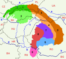
Not least in terms of the main structure, there are significant differences in common works from the one presented below. A common division is the Duklapass as the eastern border of the Western Carpathians . The forest Carpathians that begin there extend to the Prislop Pass . The Eastern Carpathians only begin here and extend over the Oituz Pass , which is only 855 m high , to the 1051 m high Predeal Pass. From there to the Temesch - Cerna furrow the Southern Carpathians rise .
According to other classifications, the boundaries of the geomorphological units run along the state borders , which is usually not useful.
Overview
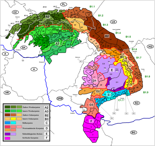
The present division is hierarchically structured into provinces, sub-provinces and areas. Each unit is assigned a number so that the location of this unit can be traced on the "Geomorphological classification of the Carpathian Mountains" map.
Some German names are given in brackets, but only if they exist as historical or geographical terms. Literal translations were not used.
In the case of geomorphological units that are located on the territory of several states, the names are given in all the respective national languages, separated by commas. If there is a plus sign (+) between the terms, this means that these terms partially or completely identify other subunits and are not to be used synonymously.
A: Western Carpathians (province)
A1: Outer Carpathian Depression (sub-province)
See attachement
A2: Outer Western Carpathians (sub-province)
a) South Moravian Carpathians (CZ) / Austrian-South Moravian Carpathians (AT) (area)
The Austro-South Moravian Carpathians CZ: Jihomoravské Karpaty:
- AT: Lower Austrian Inselbergschwelle + CZ: Mikulovská vrchovina (Nikolsburger Bergland) → A2a1
b) Central Moravian Carpathians (CZ) (area)
CZ: Středomoravské Karpaty
- Ždánický les (Steinitz Forest) → A2b1
- Litenčická pahorkatina (Litentschitz Mountains) → A2b2
- Chřiby (Mars Mountains) → A2b3
- Kyjovská pahorkatina → A2b4
c) Slovak-Moravian Carpathians (CZ / SK) (area)
CZ / SK: Slovensko-Moravské Karpaty
- CZ: Bílé Karpaty , SK: Biele Karpaty (White Carpathians) → A2c1
- CZ / SK: Javorníky (Javorník Mountains) → A2c2
- SK: Myjavská pahorkatina → A2c3
- SK: Považské podolie → A2c4
- CZ: Vizovická vrchovina (Wisowitz Uplands) → A2c5
d) Western Beskid foothills (CZ / PL) (area)
CZ: Západobeskydské podhůří, PL: Pogórze Zachodniobeskidzkie
- CZ: Podbeskydská pahorkatina , PL: Pogórze Morawsko-Śląskie → A2d1
- PL: Pogórze Śląskie → A2d2
- PL: Pogórze Wielickie → A2d3
- PL: Pogórze Wiśnickie → A2d4
e) West Beskids (CZ / SK / PL) (area)
CZ: Západní Beskydy, SK: Západné Beskydy, PL: Beskidy Zachodnie
- CZ: Hostínsko-vsetínská hornatina → A2e1
- CZ: Moravskoslezské Beskydy , SK: Moravsko-sliezske Beskydy (Moravian-Silesian Beskydy) → A2e2
- SK: Turzovská vrchovina → A2e3
- CZ: Jablunkovská brázda → A2e4
- CZ: Rožnovská brázda → A2e5
- SK: Jablunkovské medzihorie, CZ: Jablunkovské mezihoří → A2e6
- PL: Beskid Śląski , CZ: Slezské Beskydy (Silesian Beskydy) → A2e7
- PL: Kotlina Żywiecka → A2e8
f) (continued) (Polish) West Beskids (PL)
PL: Beskidy Zachodnie
- Beskid Mały (Little Beskids) → A2f1
- Beskid Makowski → A2f2
- Beskid Wyspowy (Insel Beskid ) → A2f3
- Gorce → A2f4
- Kotlina Rabczańska → A2f5
- Kotlina Sądecka → A2f6
g) Middle Beskids (SK) / (continued) (Polish) West Beskids (PL) (area)
SK: Stredné Beskydy, PL: Beskidy Zachodnie SK: Kysucké Beskydy + Oravské Beskydy + PL: Beskid Żywiecki (Saybuscher Beskydy) → A2g1
- SK: Kysucká vrchovina → A2g2
- SK: Oravská Magura → A2g3
- SK: Oravská vrchovina → A2g4
- SK: Podbeskydská brázda → A2g5
- SK: Podbeskydská vrchovina → A2g6
h) East Beskids (SK) / (continued) (Polish) West Beskids (PL) (area)
SK: Východné Beskydy, PL: Beskidy Zachodnie
- PL: Beskid Sądecki (Sandezer Beskids) + SK: Ľubovnianska vrchovina → A2h1
- SK: Čergov , PL: Góry Czerchowskie → A2h2
- SK / PL: Pieniny (partly considered part of the Podhale Magura area) → A2h3
i) Podhale Magura area (SK) / Orava - Podhale depression (PL) (area)
SK: Podhôľno-magurská oblasť, PL: Onizenie Orawsko-Podhalańskie
- SK: Skorušinské vrchy + PL: Pogórze Spisko-Gubałowskie , western part → A2i1
- SK: Podtatranská brázda , PL: Rów Podtatrzański → A2i2
- SK: Spišská Magura (Zipser Magura) + PL: Pogórze Spisko-Gubałowskie , eastern part → A2i3
- SK: Levočské vrchy (Leutschauer Berge) → A2i4
- SK: Bachureň → A2i5
- SK: Spišsko-šarišské medzihorie → A2i6
- SK: Šarišská vrchovina (Sharosher Mountains) → A2i7
- SK: Oravská kotlina + PL: Kotlina Orawsko-Nowotarska → A2i8
A3: Inner Western Carpathians (sub-province)
a) Slovak Ore Mountains (SK, HU) (area)
SK: Slovenské rudohorie, HU: Szlovák Érchegység
- SK: Veporské vrchy → A3a1
- SK: Spišsko-gemerský kras → A3a2
- SK: Stolické vrchy → A3a3
- SK: Revúcka vrchovina → A3a4
- SK: Volovské vrchy → A3a5
- SK: Čierna hora → A3a6
- SK: Rožňavská kotlina → A3a7
- SK: Slovenský kras (Slovak Karst) + HU: Észak-Borsodi karszt A3a8
b) Fatra-Tatra region (SK / PL / AT)
The Tatra-Fatra and Podhale-Magura regions are referred to as the "Central Western Carpathians" in some non-geomorphological systems - sometimes together with Vtáčnik, Kremnické vrchy, Pohronský Inovec and parts of the Považské podolie.
SK: Fatransko-tatranská oblasť
- SK: Malé Karpaty (Small Carpathians) + AT: Hainburger Berge / Hundsheimer Berge → A3b1
- SK: Považský Inovec (Waag-Inowetz) → A3b2
- SK: Tríbeč → A3b3
- SK: Strážovské vrchy → A3b4
- SK: Súľovské vrchy → A3b5
- SK: Žiar → A3b6
- SK: Malá Fatra (Little Fatra) → A3b7
- SK: Veľká Fatra (Great Fatra) → A3b8
- SK: Starohorské vrchy → A3b9
- SK: Chočské vrchy → A3b10
- SK / PL: Tatry (Tatra Mountains) → A3b11
- SK: Nízke Tatry (Low Tatras) → A3b12
- SK: Kozie chrbty → A3b13
- SK: Branisko → A3b14
- SK: Žilinská kotlina (Sillein Basin) → A3b15
- SK: Hornonitrianska kotlina → A3b16
- SK: Turčianska kotlina (fall basin) → A3b17
- SK: Podtatranská kotlina → A3b18
- SK: Hornádska kotlina → A3b19
- SK: Horehronské podolie → A3b20
c) Slovak Central Uplands (SK) (area)
SK: Slovenské stredohorie
- Vtáčnik (Bird Mountains) → A3c1
- Pohronský Inovec → A3c2
- Štiavnické vrchy (Schemnitz Mountains) → A3c3
- Kremnické vrchy ( Kremnické Mountains) → A3c4
- Poľana → A3c5
- Ostrôžky → A3c6
- Javorie → A3c7
- Krupinská planina → A3c8
- Zvolenská kotlina → A3c9
- Pliešovská kotlina → A3c10
- Žiarska kotlina → A3c11
d) Lučenec-Košice Depression (SK / HU) (area)
SK: Lučensko-košická zníženina
- SK: Juhoslovenská kotlina + HU: Középsö-Ipoly-medence + HU: Borsodi-dombság → A3d1
- SK: Bodvianska pahorkatina → A3d2
- SK: Košická kotlina + HU: Hernádvölgy-medence → A3d3
e) Mátra-Slanec region / Northern Hungarian Central Mountains (SK / HU) (region)
SK: Matransko-slanská oblasť, HU: Északi-középhegység
- HU: Börzsöny -hegység + SK: Burda → A3e1
- HU: Gödöllő dombság → A3e2
- SK: Cerová vrchovina + HU: Cserhát-hegység → A3e3
- HU: Mátra hegység → A3e4
- HU: Bükk -hegység → A3e5
- HU: Csereháti dombság → A3e6
- SK: Slanské vrchy + HU: Zempléni-hegység → A3e7
- SK: Zemplínske vrchy → A3e8 (together with Slanské vrchy Tokaj Mountains )
B: Eastern Carpathians (province)
In Ukraine, the section on its own territory and in Romania north of the Prislop Pass is referred to as "Eastern Carpathians", while in Romania the Carpathian arc from the Predeal Pass north to the Prislop Pass or to the Ukrainian state border. In Romania, a vertical division is preferred for the Eastern Carpathians on its own national territory - unlike the horizontal one listed here:
- Carpații Maramureșului și Bucovinei,
- Carpații Moldo-Transilvani,
- Carpații de Curbură.
B1: Outer Carpathian Depression (sub-province)
See attachement
B2: Outer Eastern Carpathians (sub-province)
a) Middle Beskid foothills (PL)
Sometimes considered part of the Outer Western Carpathians.
PL: Pogórze Środkowobeskidzkie
- Pogórze Rożnowskie → B2a1
- Pogórze Ciężkowickie → B2a2
- Pogórze Strzyżowskie → B2a3
- Pogórze Dynowskie → B2a4
- Pogórze Przemyskie → B2a5
- Obniżenie Gorlickie → B2a6
- Kotlina Jasielsko-Krośnieńska → B2a7
- Pogórze Jasielskie → B2a8
- Pogórze Bukowskie → B2a9
b) Lower Beskids (SK) / Middle Beskids (PL) (area)

SK: Nízke Beskydy, PL: Beskidy Środkowe
- SK: Busov → B2b1
- PL: Beskid Niski (Polish Low Beskids) → B2b2 (northern part)
- SK: Ondauer Bergland (Ondavská vrchovina) → B2b2 (southern part)
- SK: Labortzer Bergland (Laborecká vrchovina) → B2b3
- SK: Südbeskidische promontory (Beskydské Južné predhorie) → B2B4
c) East Beskids (PL) / Ukrainian Carpathians (UA) (area)
PL: Beskidy Wschodnie, SK: Poloniny, WP: Ukrajinski Karpaty Waldbeskiden (PL: Beskidy Lesiste + WP: Lisystyj Beskydy)
- PL: Bieszczady + Sanok-Turka Mountains (in Ukraine sometimes referred to as Middle Beskids) + SK: Bukovské vrchy + UA: Western Beskids → B2c1
- WP: Skoler Beskydy , also Wysoki Beskydy; Part of the (Ukrainian) East Beskydy (Schidni Beskydy) → B2c2
- Premiere : High Dniester Beskydy , part of the (Ukrainian) East Beskydy (Schidni Beskydy) → B2c3
- WP : Gorgany → B2c4
- WP : Pokuzko-Bukowinski Karpaty → B2c5
Polonina comb (WP: Polonynskyj chrebet):
- Polonyna Riwna → B2c6
- Polonyna Borschawa → B2c7
- Polonyna Kuk → B2c8
- Polonyna Krasna → B2c9
- Swydiwez → B2c10
- Tschornohora → B2c11
- Grynjawski Hory → B2c12
d) Moldova-Muntenian Carpathians (RO)
RO: Munții Carpați ai Moldo-Munteniei
- Obcinele Bucovinei (= Obcina Mare + Obcina Feredeului) → B2d1
- Munții Stânișoarei → B2d2
- Munții Tarcăului + Munții Gosmanului + Munții Berzunt → B2d3
- Depresiunea Comăneşti → B2d4
- Munții Nemira → B2d5
- Munții Ciucului , including Munții Bodocului → B2d6
- Munții Bârsei (Burzengebirge) → B2d7
- Munții Ciucaș (Crow's Stone ) + Munții Grohotiș + Munții Baiului → B2d8
- Munții Buzăului (Bosau Mountains) → B2d9
- Munții Vrancei → B2d10
- Munții Giumalău-Rarău → B2d11
B3: Inner Eastern Carpathians (sub-province)
a) Vihorlat-Gutin area (SK) / Vulkankamm (UA) (area)
SK: Vihorlatsko-Gutínska oblasť, WP: Wulkanitschnyj chrebet
- SK: Vihorlatské vrchy + WP: Wyhorlat → B3a1
- WP : Makowyzja → B3a2
- WP : Velikyj Dil → B3a3
- WP : Tupyj → B3a4
- RO: Munții Oașului + Depresiunea Oașului → B3a5
- RO: Munții Gutâiului → B3a6
- RO: Munții Țibleșului → B3a7
b) Bistrița Mountain Group (RO)
RO: Munții Bistriței
- Munții Bistriței (= Masivul Pietrosul + Masivul Budacul + Masivul Ceahlău ) → B3b1
- Obcina Mestecăniș → B3b2
- Depresiunea Dornei → B3b3
- Munții Giurgeului → B3b4
- Munții Hășmașu Mare → B3b5
c) Căliman-Harghita mountain group (RO)
RO: Munții Căliman-Harghita
- Munții Bârgăului + Munții Suhardului → B3c1
- Munții Călimani → B3c2
- Munții Gurghiului → B3c3
- Munții Harghita → B3c4
- Munții Baraolt → B3c5
- Munții Perșani ( Spirit Forest) + Măgura Codlei → B3c6
d) Giurgeu-Brașov Depression (RO)
RO: Depresiunea Giurgeu-Brașovului
- Depresiunea Giurgeului → B3d1
- Depresiunea Ciucului → B3d2
- Depresiunea Brașovului → B3d3
e) Maramuresch-Rodnaer area
- Maramures Depression, RO: Depresiunea Maramureșului, UA: Мармароська улоговина → B3e1
- Maramures Mountains , RO: Munții Maramureșului, UK: Мармароський масив → B3e2
- Rodna Mountains , RO: Munții Rodnei, UK: Родна гори → B3e3
C: Southern Carpathians (RO) (Province)
C1: Outer Carpathian Depression
See attachement
C2: Bucegi mountain range
RO: Grupa Munții Bucegi
- Munții Bucegi → C2.1
- Munții Leaotă → C2.2
- Culoarul Rucăr-Bran → C2.3
C3: Făgăraș mountain group
RO: Grupa Munții Făgărașului
- Munții Făgărașului → C3.1
- Munții Iezer → C3.2
- Munții Piatra Craiului (Königsteingebirge) → C3.3
- Munții Cozia → C3.4
- Depresiunea Loviștei → C3.5
C4: Parâng mountain group
RO: Grupa Munții Parângului
- Munții Parângului + Munții Latoriței → C4.1
- Munții Șureanu / M. Sebeșului → C4.2
- Munții Cindrel / M. Cibinului ( Zibins Mountains ) → C4.3
- Munții Lotrului → C4.4
- Munții Căpățânii → C4.5
- Depresiunea Petroșani → C4.6
C5: Retezat-Godeanu mountain range
RO: Grupa Munții Retezat-Godeanu
- Munții Retezat → C5.1
- Munții Godeanu → C5.2
- Munții Vâlcanului → C5.3
- Munții Mehendinți → C5.4
- Munții Cernei → C5.5
- Munții Țarcu → C5.6
D: Western Romanian Carpathians (RO)
RO: Carpații Occidentali
D1: Apuseni Mountains
a) Kreisch Mountain Group (Munții Criș):
- Dealurile Crișene (incl. Depresiunea Baia Mare , Dealurile Salajului (Silvaniei), Dealurile Crasnei , Depresiunea Vad-Borod , Depresiunea Beius , Depresiunea Zarandului ) → D1a1
- Pădurea Craiului → D1a2
- Munții Codru-Moma → D1a3
b) Seș-Meseș Mountain Group (Munții Seș-Meseșului):
- Munții Meseșului → D1b1
- Muntele Seș → D1b2
- Depresiunea Șimleu , partially viewed as part of the Transylvanian Plateau (Podișul Someșan) → D1b3
- Munții Șimleu , partially viewed as part of the Transylvanian Plateau (Podișul Someșan) → D1b4
c) Bihor massif (Masivul Bihor):
- Munții Bihorului (including Munții Vlădeasa and Găina ) → D1c1
- Muntele Mare → D1c2
- Munții Gilăului → D1c3
d) Mureș Mountain Group (Munții Mureșului):
- Munții Zarandului → D1d1
- Transylvanian Ore Mountains ( Romanian : Munții Metaliferi ), incl. Trascău Mountains ( Roman . Munții Trascăului ) → D1d2
D2: Poiana-Ruscă Mountains
RO: Munții Poiana Ruscă (partially considered as part of the Southern Carpathians)
- Poiana Ruscă → D2.1
- Podișul Lipovei → D2.2
- Culoarul Orăștiei , including Depresiunea Hațegului → D2.3
D3: Banat Mountains (RO, SRB)
RO: Munții Banatului (partially considered as part of the Southern Carpathians)
- Munții Banatului (in the narrower sense, = Munții Semenic , Munții Locvei , Munții Aninei , Munții Dognecei ) → D3.1
- Almăj Mountains → D3.2
- Culoarul Timiș-Cerna , incl. Depresiunea Almăj → D3.3
- Vršačke Planine → D3.4
E: Transylvanian Basin (RO)
Partly regarded as not belonging to the Carpathian Mountains.
1: Transylvanian Depression (RO: Depresiunea Transilvaniei)
- Depresiunea Mureș-Turda → E1.1
- Depresiunea Sibiului → E1.2
- Depresiunea Făgărașului → E1.3
2: Transylvanian Plateau (RO: Podișul Transilvaniei):
- Podișul Târnavelor (Kokel highlands), including Podișul Hârtibaciului (Harbach highlands) and Podișul Secașelor (Zekesch highlands) → E2.1
- Câmpia Transilvaniei (or Podișul Transivaniei) (Transylvanian Heath) → E2.2
- Podișul Someșan (Somesch Highlands) → E2.3
Q: Serbian Carpathians (SRB)
Serbian: Karpatske planine. Partly as part of the Southern Carpathians, partly as not belonging to the Carpathian Mountains.
- Miroč planina → F1
- Homoljske planine → F2
- Veliki i Mali Krš → F3
- Deli Jovan → F4
- Beljanica planina → F5
- Kučajske planine → F6
- Rtanj planina → F7
- Ozren i Devica → F8
Appendix: Outer Carpathian Depression
The Outer Carpathian Depression is usually treated as part of the Carpathian Sections (Western, Eastern and Southern Carpathians). However, since their exact subdivision and delimitation are handled very contradictory, only a list of the sub-units from west to east to south is given here:
- AT: Weinviertel hill country + CZ: Dyjsko-svratecký úval (Thaya-Schwarza valley) → A1.1
- CZ: Vyškovská brána (Wischauer Gate) → A1.2
- CZ: Hornomoravský úval (Hohe Gesenk, Upper March basin) → A1.3
- CZ: Moravská brána (Moravian Gate) → A1.4
- CZ: Ostravská pánev (Ostrava Basin), PL: Kotlina Ostrawska A1.5
- PL: Kotlina Oświęcimska (Auschwitz Valley) → A1.6
- PL: Brama Krakowska → A1.7
- PL: Kotlina Sandomierska + WP : Sansko-Dnistrowska riwnyna → B1.1
- WP : Verkhnodnistrowska riwnyna → B1.2
- WP : Drohobytschka vysochyna → B1.3
- WP : Pridnistrowska riwnyna → B1.4
- WP : Pokutska vysotschyna → B1.5
- WP : Bukowynska wysotschyna + RO: Podișul Sucevei → B1.6
- RO: Culoarul Moldova-Siret → B1.7
- RO: Subcarpații Moldovei → B1.8
- RO: Subcarpații Munteniei (Subcarpații de Curbură) → B1.9
- RO: Subcarpații Getici → C1.1
Footnotes
- ↑ Meyers Großes Universallexikon, Vol. 7 Ih – Kn (1983), p. 480
- ↑ Diercke World Atlas, 141st edition 1968
- ↑ The Saybuscher Beskids (Beskid Żywiecki) lie on the border between Poland and Slovakia. For the Slovak part there is also the term Slovenské Beskydy, which in turn is often divided into Kysucké Beskydy and Oravské Beskydy.

