Hochfelden (Bas-Rhin)
| Hochfelden | ||
|---|---|---|

|
|
|
| region | Grand Est | |
| Department | Bas-Rhin | |
| Arrondissement | Saverne | |
| Canton | Bouxwiller | |
| Community association | Pays de la Zorn | |
| Coordinates | 48 ° 46 ′ N , 7 ° 34 ′ E | |
| height | 155-222 m | |
| surface | 15.76 km 2 | |
| Residents | 3,987 (January 1, 2017) | |
| Population density | 253 inhabitants / km 2 | |
| Post Code | 67270 | |
| INSEE code | 67202 | |
| Website | www.hochfelden.fr | |

Hochfelden is a French commune with 3987 inhabitants (as of January 1, 2017) in the Bas-Rhin department in the Grand Est region (until 2015 Alsace ). It is the administrative seat of the Communauté de communes du Pays de la Zorn . On January 1, 2015, the municipality moved from the Arrondissement Strasbourg-Campagne to the Arrondissement Saverne .
history
Hochfelden is mentioned for the first time in 816 under the name Hocfeldis . The spellings Hoffelden and Hochfeld are also found later .
Until the Jews were exiled to southern France in 1940, Hochfelden had a Jewish community. There was a synagogue in Hochfelden since 1841. At that time the church had over 200 members.
On July 13, 1941, the eve of the French national holiday , around 200 young people demonstrated against the occupation by National Socialist Germany by demonstratively parade in front of the French national flag, singing the Marseillaise . In the following days, 108 of them were arrested by the Gestapo and taken to the Vorbruck-Schirmeck security camp .
On January 1, 2017, the community of Schaffhouse-sur-Zorn was incorporated into Hochfelden.
Population distribution and extrapolation
| District | former INSEE code |
Area (km²) |
Altitude (m) | Population (Census) | ||||||||||
|---|---|---|---|---|---|---|---|---|---|---|---|---|---|---|
| 1962 | 1968 | 1975 | 1982 | 1990 | 1999 | 2006 1 | 2008 2 | 2011 1 | 2013 2 | 2016 3 | ||||
| Hochfelden | 67202 | 12.09 | 155-222 | 2,755 | 2,895 | 2,942 | 2,877 | 2,781 | 2,944 | 3,036 | 3,195 | 3,453 | 3,516 | 3,552 |
| Schaffhouse-sur-Zorn | 67439 | 3.67 | 158-214 | 291 | 270 | 249 | 307 | 307 | 349 | 383 | 393 | 392 | 405 | 406 |
| Hochfelden | 67202 | 15.76 | 3,046 | 3.165 | 3.191 | 3,184 | 3,088 | 3,293 | 3,419 | 3,588 | 3,845 | 3,921 | 3,958 | |
coat of arms
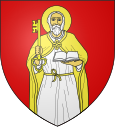
The coat of arms shows St. Peter with his insignia, key and book.
economy
Beer has been brewed in Hochfelden since 870 . The local family brewery Meteor runs a pub and a museum. Guided tours are offered.
The Rohrbach garbage dump is heavily contaminated with lindane and has to be monitored by the state.
Partner communities
- Hochfelden in Switzerland
Attractions
- Former synagogue and former Jewish schoolhouse, in which the local history museum is located today.
literature
- Le Patrimoine des Communes du Bas-Rhin . Flohic Editions, Volume 1, Charenton-le-Pont 1999, ISBN 2-84234-055-8 , pp. 507-510.
Web links
Individual evidence
- ↑ http://www.legifrance.gouv.fr/eli/decret/2014/12/29/2014-1722/jo/texte
- ^ Janine Doerry: Nazi Forced Camps in West Germany, France and the Netherlands: History and Memory . Schöningh, 2008, ISBN 978-3-506-76458-4 , pp. 70 .
- ↑ Populations légales 2006 & 2011 & 2016
- ↑ Populations légales 2013 & 2008
- ↑ File of the Bas-Rhin department - population census (Recensement de la population) 2016
- ↑ Des villages de Cassini aux communes d'aujourd'hui - Index par département
- ↑ BASOL (contaminated soil) website Ministère du développement durable (in French).
- ↑ asccre.ch: Liste_Partschaftenen.pdf (application / pdf-Objekt) ( page no longer available , search in web archives ) Info: The link was automatically marked as defective. Please check the link according to the instructions and then remove this notice. , Accessed February 17, 2010


