
Thieving
| coat of arms | Germany map | |
|---|---|---|

|
Coordinates: 50 ° 19 ′ N , 7 ° 28 ′ E |
|
| Basic data | ||
| State : | Rhineland-Palatinate | |
| County : | Mayen-Koblenz | |
| Association municipality : | Rhine-Moselle | |
| Height : | 72 m above sea level NHN | |
| Area : | 17.68 km 2 | |
| Residents: | 2656 (Dec. 31, 2019) | |
| Population density : | 150 inhabitants per km 2 | |
| Postal code : | 56332 | |
| Area code : | 02607 | |
| License plate : | MYK, MY | |
| Community key : | 07 1 37 207 | |
| LOCODE : | DE 82V | |
| Community structure: | 6 districts | |
| Association administration address: | Bahnhofstrasse 44 56330 Kobern-Gondorf |
|
| Website : | ||
| Local Mayor : | Andreas Perscheid ( CDU ) | |
| Location of the local community Dieblich in the Mayen-Koblenz district | ||
 |
||


Dieblich is a local community and a wine and fruit growing place on the so-called Terrassenmosel in the Rhineland-Palatinate district of Mayen-Koblenz . It belongs to the Rhein-Mosel community , which has its administrative headquarters in Kobern-Gondorf .
geography
Geographical location
Dieblich is located on the right bank of the Moselle about 15 kilometers from Koblenz and about 35 kilometers from Cochem on the sliding slope of the Dieblicher Moselle arc. Neighboring towns are Niederfell upstream and Lay , a district of Koblenz, downstream . On the other side of the Moselle is Kobern-Gondorf . The community of Waldesch borders the Mariaroth district .
Expansion of the municipal area
The district of Dieblich stretches over a length of about 2 kilometers along the banks of the Moselle. The district of Dieblich-Berg is located above the mountain surrounded by the Moselle. The community also includes the districts of Mariaroth and Naßheck, which geographically already belong to the Hunsrück , as well as the residential areas Am Forsthaus, Bauhöfe, Kondertal, Kührerhof, Lohbuschhof, Silberberghof, Talwel, Heidehof.
climate
Like other communities in the Lower Moselle , Dieblich is located in one of the warmest regions of Germany with a favorable climate.
history
Dieblich was first mentioned under the name Divelich in a document from Archbishop Theodoric II of Trier from April 20, 1231.
- Population development
In the Trier fire book of 1563 , the number of fireplaces in the community of Dieblich is given as 52.
The development of the population of Dieblich, the values from 1871 to 1987 are based on censuses:
|
|

politics
Municipal council
The municipal council in Dieblich consists of 20 council members, who were elected in a personalized proportional representation in the local elections on May 26, 2019 , and the honorary local mayor as chairman. By 2019, the council had 16 council members.
The distribution of seats in the municipal council:
| choice | SPD | CDU | FWG | total |
|---|---|---|---|---|
| 2019 | 3 | 10 | 7th | 20 seats |
| 2014 | 2 | 9 | 5 | 16 seats |
| 2009 | 2 | 9 | 5 | 16 seats |
| 2004 | 3 | 8th | 5 | 16 seats |
- FWG = Free Voter Group Dieblich e. V.
mayor
Andreas Perscheid (CDU) became the local mayor of Dieblich in 2004. In the direct election on May 26, 2019, he was confirmed in office for a further five years with a share of 54.01% of the votes.
coat of arms
|
|
Blazon : "Divided by silver and red, above a continuous (cut) red bar cross, below a silver heraldic rose without sepals with golden lugs, one petal pointing downwards." |
| Justification of the coat of arms: The red cross indicates that the place belonged to Kurtrier (until the end of the 18th century), the white rose to the knightly family of those von Dieblich, called von Mielen, who led a red rose in silver (14th century) . |
Unofficial coats of arms of the district:

mountain

Yards
Mariaroth

Wet tail

Kondertal


Community partnerships
Dieblich maintains partnerships with the French town of Marzy in Burgundy and with the Belgian town of Heers in the Flanders region .
Culture and sights
Buildings

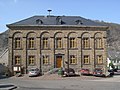
- The old school, built in 1829 by Johann Claudius von Lassaulx , stands in the middle of the village . The municipal administration is located there today.
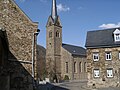
- The Catholic parish church of St. Johannes was built by Ferdinand Nebel from 1844 to 1848 .
- Near the church there is an old castle house with a striking hipped roof with a double row of dormer windows - the Heesenburg. It comes from the 13th century and belonged to the von der Arken family in Koblenz. In 1514 Marsilius von Arken sold the property to the Muhl von Ulmen family . Baron Johann Philipp Ernst von und zu der Hees inherited the castle in 1762. The east side has a single-storey half-timbered building with a gable end, the southwest corner one of the four original oriels rebuilt recently as an octagonal half-timbered bay.
- Another former castle, the Zanter- or Zanderburg, also got its name from one of its last owners, the Zandt von Merl family. Originally from the long-established noble family Hase von Dieblich in the 13th / 14th centuries. Built in the 16th century, after the family with Eberhard Hase von Dieblich died out, the noble house came to Ruprecht von Reil in 1479, and later to the Koblenz bailiff Dietrich von Dietz. Then the Zandt von Merl family followed until 1679, which died out with IH Zandt von Merl. The barons of Hohenfeldt later inherited the property from him. After that, the building served as a rectory for a longer period of time.
- See also the list of cultural monuments in Dieblich
Economy and Infrastructure
Viticulture and fruit growing

Dieblich is a wine and fruit growing community. The place belongs to the "Burg Cochem wine-growing area " in the Moselle growing region . Three wine-growing businesses are active in the village, the area under vines is 2 hectares. About 80% of the wine grown are white grape varieties (as of 2010).
The only Dieblicher vineyard (Dieblicher Heilgraben) is located upstream of the Moselle in the direction of Niederfell. Down the Moselle and on the Dieblicher Berg there are apple, sweet cherry and plum plantations. Vegetables (including asparagus and pumpkins) and cereals are also grown on the Dieblicher Berg.
traffic

Along the right bank of the Moselle, the B 49 Koblenz - Treis-Karden - Cochem leads through the village. There is a connection to the A 61 via the B 411 . The Dieblich junction is located in the immediate vicinity of the Moselle valley bridge, over which the A 61 spans the Moselle at a height of about 136 meters.
There is a regular bus connection in the direction of Koblenz and Burgen .
The ferry connection to Kobern-Gondorf was discontinued in the 1970s. Since 1977 there has been a bridge connection between Kobern-Gondorf and Niederfell with the Moselle gold bridge.
education
- There is a primary school in the district of Dieblich.
- Dieblich has its own kindergarten.
Others
nature

On the banks of the Moselle near Dieblich you can still find the extremely rare dice snake that lives in the water. For this reason, the banks of the Moselle were placed under nature protection a few years ago. The nature reserve stretches from the former Dieblich ferry pier to the Moselle gold bridge that connects Niederfell with Kobern-Gondorf. The area of the ferry pier has been renatured. Signs put up on the B 49 and on the Moselle foreland provide information about the nature reserve.
SWR transmitter
In the vicinity of Dieblich the Südwestrundfunk operates a transmitter for VHF and television, the transmitter Koblenz (Dieblich-Naßheck) . A 280 meter high guyed steel framework mast is used as the antenna carrier.
photos
Old school
Parish church
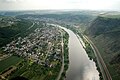
Aerial photograph 2007


Web links
Individual evidence
- ↑ State Statistical Office of Rhineland-Palatinate - population status 2019, districts, communities, association communities ( help on this ).
- ↑ State Statistical Office Rhineland-Palatinate (ed.): Official directory of the municipalities and parts of the municipality. Status: January 2019 [ Version 2020 is available. ] . S. 44 (PDF; 3 MB).
- ↑ a b State Statistical Office Rhineland-Palatinate - regional data
- ^ Regional Returning Officer Rhineland-Palatinate: Local elections 2019, city and municipal council elections
- ^ The State Returning Officer of Rhineland-Palatinate: direct elections 2019. see Rhein-Mosel, Verbandsgemeinde, fifth row of results. Retrieved January 11, 2020 .

Eight | Alkene | Andernach | Look | Arft | Baar | Bassenheim | Bell | Bendorf | Bermel | Boos | Brey | Brodenbach | Castles | Thieving | Ditscheid | Agree | Ettringen | Gappenach | Low | Gierschnach | Hatzenport | Hausten | Herresbach | Shepherds | Cold | Kaltenengers | Sweeping | Notches | Chained | Kirchwald | Kobern-Gondorf | Kollig | Kottenheim | Kretz | Kruft | Langenfeld | Langscheid | Clay | Lind | Löf | Lonnig | Luxem | Quirks | Mayen | Mendig | Mertloch | Monreal | Mülheim-Kärlich | Münk | Münstermaifeld | Night home | Naunheim | Nickenich | Niederfell | Niederwerth | Nörtershausen | Upper skin | Notice | Pillig | Plaidt | Polch | Reudelsterz | Rhens | Vineyards | Over | Saffy | Sankt Johann | Saint Sebastian | Siebenbach | Spay | Door | Trimbs | Urbar | Urmitz | Vallendar | Virneburg | People's field | Waldesch | Hamlet | Weißenthurm | Weitersburg | Welling | Welschenbach | Wierschem | Winningen | Clouds