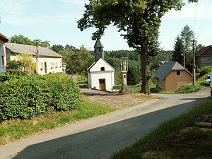
Lhotka u Přerova
| Lhotka | ||||
|---|---|---|---|---|
|
||||
| Basic data | ||||
| State : |
|
|||
| Region : | Olomoucký kraj | |||
| District : | Přerov | |||
| Area : | 190 ha | |||
| Geographic location : | 49 ° 30 ' N , 17 ° 24' E | |||
| Height: | 274 m nm | |||
| Residents : | 62 (Jan. 1, 2019) | |||
| Postal code : | 751 24 | |||
| License plate : | M. | |||
| traffic | ||||
| Street: | Kokory - Čekyně | |||
| structure | ||||
| Status: | local community | |||
| Districts: | 1 | |||
| administration | ||||
| Mayor : | Milan Trnčák (as of 2008) | |||
| Address: | Lhotka 6 751 24 Přerov 4 |
|||
| Municipality number: | 514527 | |||
| Website : | www.lhotka.unas.cz | |||
Lhotka (German Klein Lhotta ) is a municipality in the Czech Republic . It is located seven kilometers north of Přerov and belongs to the Okres Přerov .
geography
Lhotka is located in the southern foothills of the Oder Mountains on a slope on the right-hand side above the Olešnice valley. The Sobíšký vrch (318 m) rises to the east and the Žalkov (291 m) to the south. The place can only be reached via a road from the valley.
Neighboring towns are Penčičky and Penčice in the north, Zábeštní Lhota in the northeast, Sobíšky in the east, Borošín and Čekyně in the southeast, Žeravice in the southwest, Kokory and Čelechovice in the west and Nelešovice in the northwest.
history
The settlement of the village took place in the 11th century. The Moravian village was one of the many settlements founded according to the Lhot system , whose settlers were exempt from duties and services to the authorities for a certain period of time. The first known owner of the village is Vikan von Majetín from the 13th century. The first written mention of Malá Lhota took place in 1355. The place was later referred to as Lhotka Hřivínova and was a small settlement consisting of seven houses.
From 1447 the village was part of the Čekyně dominion. In that year the four daughters of Diviš from Čekyně sold the estate with the villages Jurkov (Jurkova Lhota), Kokory , Lhotka Zábeštní ( Zábeštní Lhota ), Lhotka Hřivínova and the Freihof Vinary to Jan Mukař from Kokor. After his death the brothers Vilém, Kuneš and Jan von Vrchlabí inherited the property. The family named themselves after the episcopal man's back Kurovice from 1507 Kurovský from Vrchlabí. Subsequently, the owners changed frequently. The name of the village developed from Hřivínova Lhota to Malá Lhota . After the Thirty Years' War there were only five houses left in the village. The place has had a seal since 1748.
After the abolition of patrimonial Malá Lhota formed a municipality in the Kroměříž district from 1850. In 1880 it was assigned to the Přerov district. Since 1910 the place has been called Lhotka . In 1970 Lhotka consisted of 22 houses, in 1991 there were 16.
Community structure
No districts are designated for the municipality of Lhotka.
Attractions
- Chapel of the Holy Guardian Angel on the village square
- Lhotka u Přerova nature reserve, the 5-hectare terrain on the southern slopes of the Olešnice, was designated in 1951.


