Lom u Blatné
| Lom | ||||
|---|---|---|---|---|
|
||||
| Basic data | ||||
| State : |
|
|||
| Region : | Jihočeský kraj | |||
| District : | Strakonice | |||
| Area : | 569 ha | |||
| Geographic location : | 49 ° 25 ' N , 13 ° 59' E | |||
| Height: | 474 m nm | |||
| Residents : | 120 (Jan. 1, 2019) | |||
| Postal code : | 388 01 | |||
| License plate : | C. | |||
| traffic | ||||
| Street: | Sedlice - Mirotice | |||
| Next international airport : | České Budějovice Airport | |||
| structure | ||||
| Status: | local community | |||
| Districts: | 2 | |||
| administration | ||||
| Mayor : | Václav Kafka (as of 2018) | |||
| Address: | Lom 9 388 01 Blatná |
|||
| Municipality number: | 536822 | |||
| Website : | www.obeclom.eud.cz | |||
Lom (German 1939–1945 Bruch ) is a municipality in the Czech Republic . It is located four kilometers southwest of Mirotice in South Bohemia and belongs to the Okres Strakonice .
geography
Geographical location
Lom is located on the upper reaches of the Neradovský creek in the Central Bohemian hill country . The Strážovická hora (495 m) rises to the northeast, the Mužetický vrch (573 m) to the south, the Chlum (562 m) and the Holý vrch (513 m) to the southwest, the Pahorek (531 m) to the west and the Homole (to the northwest). 484 m). Pančár Pond lies to the southeast.
Community structure
The municipality of Lom consists of the districts Lom and Míreč ( Miretsch ) and the settlement Neradov ( Neradow ).
Neighboring communities
Neighboring towns are Míreč and Stráž in the north, Kopaniny, Brabčulka, Hořejší Mlýn, Mirotice and Strážovice in the north-east, Radobytce and Obora u Radobytec in the east, Bořice and Jarotice in the south-east, Důl and Mužetice in the south, Chlum, Sedlice and Škvořetice in the south-west and Pacelice in the west and Buzice , Zbuzy, Buzičky, Neradov, Václavov and Laciná in the northwest.
history
The first written mention of Lom took place on August 24, 1341 in a certificate of confirmation from King John of Luxembourg about the privileges granted to the church in Mirotice on February 2, 1299 by King Wenceslaus II . In it, the Lom farm with fields, forests and meadows was listed as the property of the church. In 1591 the village consisted of eight farms, two chalets and a Kretscham . Adam Lev von Rosental sold Lom in 1541 together with the town of Mirotice to Johann and Sigmund Kalenitz von Kalenitz on Skworetitz . From 1558 Johann Kalenitz von Kalenitz was the sole owner of Skworetitz. In the 17th century, the estate belonged to Georg Franz Daudlebsky von Daudleb, who sold it to Wilhelm Kalenitz von Kalenitz in 1672. In 1701 Joseph Count Serényi von Kis-Serény acquired the Skworetitz estate and united it with the Blatná domain. In 1720 there were four farms, two chalupners and three residents in Lom. Neradov was built on the site of a hut belonging to the Skworetitz estate and was originally called Huť ; In 1774 the settlement consisted of four houses. In 1785 Lom consisted of 16 houses. Joseph Count Serényi bequeathed the rule to his widow Maria Elisabeth, née Countess von Waldstein, for usufruct in 1742 . After their death in 1787 the brothers Joseph Vinzenz, Amand, Johann Nepomucen and Ludwig Serényi inherited from Kis-Serény. They sold the Blatná rule on November 7, 1798 to the Imperial and Royal Chamberlain Wenzel Hildprandt Freiherr von und zu Ottenhausen. In 1803 his son Franz Hildprandt von und zu Ottenhausen inherited the property.
In 1840 Lom consisted of 39 houses with 209 Czech-speaking residents, including an Israelite family. There was a farm and a sheep farm in the village. The one-layer Neradow and Hutj ( Neradov ), consisting of 10 Dominikal houses, lay aside . The parish was Mirotitz . Until the middle of the 19th century, Lom was always subject to the Blatná rule.
After the abolition of patrimonial formed Lom Neradov 1850 a district of the municipality Mužetice in the district administration and the judicial district Blatná. A total of 365 people lived in Lom, Míreč and Neradov in 1865. From 1880 Lom and Neradov were considered two separate districts of Mužetice. In 1887 Lom, Míreč and Neradov broke away from Mužetice and formed the municipality of Lom. In 1900 it had 321 inhabitants. The volunteer fire brigade was formed in 1913. In 1914 the village of Lom with Neradov consisted of 37 houses. In 1921 360 people lived in the community, in 1950 there were 240. In the course of the abolition of the Okres Blatná in 1960, Lom was assigned to the Okres Strakonice. In 1970 the number of inhabitants in the municipality had fallen to 195. On July 1, 1974 it was incorporated into Škvořetice . After a referendum, Lom, Míreč and Neradov broke away from Škvořetice on November 24, 1990 and formed their own municipality. In 2008 there were 114 people living in Lom, Míreč and Neradov.
Culture and sights
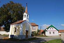
- Chapel in Lom, built in 1882 in place of a wooden bell tower
- Chapel in Neradov, built in 1933
- Indian village and fortress of the fur hunters Fort Hary near Jarotice
Individual evidence
- ↑ Český statistický úřad - The population of the Czech municipalities as of January 1, 2019 (PDF; 0.8 MiB)
- ↑ Johann Gottfried Sommer : The Kingdom of Bohemia. Represented statistically and topographically. Volume 8: Prachiner Circle. Calve, Prague 1840, p. 98.


