
Radomyšl
| Radomyšl | |||||
|---|---|---|---|---|---|
|
|||||
| Basic data | |||||
| State : |
|
||||
| Region : | Jihočeský kraj | ||||
| District : | Strakonice | ||||
| Area : | 2520.44 ha | ||||
| Geographic location : | 49 ° 19 ' N , 13 ° 56' E | ||||
| Height: | 455 m nm | ||||
| Residents : | 1,341 (Jan 1, 2019) | ||||
| Postal code : | 387 31 | ||||
| License plate : | C. | ||||
| traffic | |||||
| Street: | Strakonice - Sedlice | ||||
| Railway connection: | Březnice – Strakonice | ||||
| Next international airport : | České Budějovice Airport | ||||
| structure | |||||
| Status: | Městys | ||||
| Districts: | 6th | ||||
| administration | |||||
| Mayor : | Ing.Luboš Peterka (as of 2018) | ||||
| Address: | Maltézské nám. 82 387 31 Radomyšl |
||||
| Municipality number: | 551660 | ||||
| Website : | www.radomysl.net | ||||


Radomyšl [ ˈradɔmɪʃl ] (German Radomischl ) is a minority town in the Czech Republic . It is located seven kilometers north of Strakonice in South Bohemia and belongs to the Okres Strakonice .
geography
Geographical location
Radomyšl is located in the Central Bohemian Uplands in the valley basin of the Radomyšlský creek. The Svatý Jan (497 m) rises to the east, the Chlum (544 m) and Dominový vrch (499 m) to the southeast, the Věna (486 m) to the south and the Tisovník (589 m) to the south-west. To the northwest is the Malducky pond. The Březnice – Strakonice railway runs on the south-eastern edge of the village .
Community structure
The minority Radomyšl consists of the districts Domanice ( Domanitz ), Láz ( Laas ), Leskovice ( Leskowitz ), Podolí ( Podol ), Radomyšl ( Radomischl ) and Rojice ( Rojice ), the settlement Kaletice ( Kalletitz ) and the single layers U Mikuláše.
The municipality is divided into the cadastral districts of Domanice, Kaletice, Láz u Radomyšle, Leskovice u Radomyšle, Podolí u Strakonic, Radomyšl and Rojice.
Neighboring communities
Neighboring towns are U Mikuláše, Láz and Rojice in the north, Velká Turná and Malá Turná in the northeast, Petrovice, Osek in the east, Rohozná in the southeast, Rovná and Domanice in the south, Kaletice, Černíkov and Hubenov in the southwest, Podolí and Klínovice in the west and Zadní Zborovice, Třebohostice and Chrášťovice in the northwest.
history
The area at the crossroads of several trade routes had been inhabited since the 5th century. The discovery of a Slavic burial site from the 12th century in the center of the village is evidence of the settlement during the Slav period. There was also a so-called vampire grave under it.

The first written mention of the Radomyšl parish was made in 1284 in a property register of the Bavor von Strakonitz . On September 3, 1320, Wilhelm Bavor von Strakonitz left the parish and church in Radomyšl, which was first called the town ( civitacula ), to the Order of St. John . News from the period between 1352 and 1405 show that Radomyšl was under the clerical administration of the Bozeň deanery ( bozeňský děkanát ). During this time, the church of St. Martin was also rebuilt, which is documented in the construction books since 1384. In 1355 Radomyšl was again called a settlement. In 1359, Wilhelm Bavor von Strakonitz and his wife Margarete transferred the Radomyšl estate with all its accessories to the Johanniter Grand Priory. Radomyšl was until 1375 under the curia widow seat of Margarethe von Strakonitz.
In the 15th and 16th centuries Radomyšl rose again to a town. Around 1480 Racek von Kocov attacked Radomyšl on a foray and set the place on fire, and the old town charter was lost. On September 10, 1483, the Strakonice convent under Johann von Schwanberg renewed the old privileges of Radomyšl and at the same time granted the authorities the right to freely dispose of the reasons against payment of interest. At the request of the citizens, Grand Prior Johann von Rosenberg extended Radomyšl's rights in 1516 to include exemption from the death fee as well as the right of succession and testamentary disposition. At the same time he granted the right to keep their own orphan registers and their own orphan rights. Subsequently, the Radomysl privileges were confirmed by each new Grand Prior of the Johanniter, who called themselves Maltese from 1530 onwards. The land register, which has been in existence since 1569, is one of the oldest in the Strakonitz estate. This also shows the urban development of Radomyšl, which in the Middle Ages consisted of twelve plots, had grown to 17 plots in 1569 and 25 in 1583. In 1605, Grand Prior Matouš Děpolt von Lobkowicz gave a town a coat of arms.


Grand Prior Ferdinand Ludwig Kolowrat -Liebsteinsky granted the citizens exemption from natural robots in 1679 against an annual retirement of 120 guilders. The head of the town was the market judge . In 1736, Grand Prior Gundacker Poppo, Imperial Count von Dietrichstein, had the pilgrimage church of St. John the Baptist put on. Since 1784 it has also served as a burial church for the Radomyšl parish. In 1811 the parish church of St. Martin was elevated to the status of Dechanteikirche.
In 1840 the submissive market town Radomischel / Radomyssle consisted of 95 houses with 498 inhabitants. In the village there was the Dechanteikirche of St. Martin, a school and parish. The former Meierhof formed the dean's endowment. The Church of St. Martin was the parish church for Radomischel, Kalletitz ( Kaletice ), Rohozna ( Rohozná ), Podoly ( Podolí ), Klinowitz ( Klínovice ), Aunitz , Hubenow ( Hubenov ), Hinter-Zborowitz ( Zadní Zborovice ), Wosek , Klein-Turna ( Malá Turná ), Petrowitz ( Petrovice ), Gemnitz ( Jemnice ), Domanitz ( Domanice ), Černiekow ( Černíkov ), Kraschtowitz , Leskowitz ( Leskovice ), Laas ( Láz ), Rogitz ( Rojice ), Groß-Turna and Střebohostitz . Until the middle of the 19th century, the market town always remained subservient to Strakonitz.
After the abolition of patrimonial formed Radomyšl / Radomyshl 1850 with the districts Kaletice and Láz a market town in the district administration and the judicial district Strakonice. Láz broke up in 1887 and formed its own community. 1899 after the local railway Strakonitz – Blatná – Březnitz the operation on the railway line Březnitz – Strakonitz on.
In 1948 Radomyšl lost its minority status and became a village. Kaletice lost its status as a district in 1961. In 1964 Domanice and Leskovice were incorporated, on November 26, 1971 Rojice followed (with Láz). Podolí was umgemeindet on April 1, 1976 from Droužetice to Radomyšl. In 2005 Radomyšl was named village of the year in Jihočeský kraj . On October 10, 2006 the status as Městys was renewed.
Community partnerships
- Montoggio , Italy, since 2006
Culture and sights

- Dechanteikirche of St. Martin, the originally Romanesque building was built in the 12th century. The first renovations took place in the last quarter of the 13th century. Around 1388, the church was expanded and redesigned in the Gothic style. It received its current baroque appearance at the beginning of the 18th century. The cemetery wall was also adapted to the surrounding street layout and an ossuary was created in the northwest corner of the cemetery. The old cemetery was closed in 1784 and transferred to the Church of St. John the Baptist relocated. The ossuary was converted into a Holy Sepulcher in 1877.
- High baroque pilgrimage and burial church of St. John the Baptist with a cemetery on the Johannesberg ( Janský vrch ) southeast of the town. It was built in 1733–1736 in place of an older Renaissance building. The order for this was given to the Prague fortress builder Bartolomeo Scotti, who had previously carried out the renovation of the Grand Priory on Prague's Lesser Town . The plans for the construction of the church come from Anselmo Lurago , a relative of Scotti, who also carried out the execution. A way of the cross with 14 chapels from the Radomyšlský potok valley leads from the Vraždy pond to the church. The cemetery offers a wide view of the surrounding hill country.
- City Hall, the classicist building was built between 1832 and 1836
- Marian column in front of the town hall, erected in 1860
- Former Dechantei, built in 1642. The baroque renovation took place in 1763–1767. It was confiscated from the Order of Malta in 1948
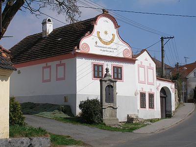
- House No. 62, an ornate baroque building from 1784
- House number 11, the house where Josef Kovář was born
- Birth house of Norbert Fabián Čapek
- Bohumír Lifka's birth house
- several crossroads and wayside shrines

Birth house of Norbert Fabián Čapek

Bohumír Lifka's birth house
House number 62 in the peasant baroque style

Wayside shrine on the former route to Osek


_(15).jpg)
Sons and daughters of the church
- Josef Kovář (1779–1848), discoverer of the Grünberg manuscript
- Norbert Fabián Čapek (1870–1942), religious thinker and Unitarian, he was gassed in Hartheim .
- Miloslav Novotný (1894–1966), poet and literary historian
- Bohumír Lifka (1900–1987), librarian and book author
- Jan Matějka (1918–1976), pilot of the Czechoslovak RAF squadron and persecuted by the communist regime
Individual evidence
- ↑ Český statistický úřad - The population of the Czech municipalities as of January 1, 2019 (PDF; 0.8 MiB)
- ↑ Johann Gottfried Sommer : The Kingdom of Bohemia. Represented statistically and topographically. Volume 8: Prachiner Circle. Calve, Prague 1840, p. 124.
- ↑ http://www.radomysl.net/detail.php?ID=3
- ↑ http://www.radomysl.net/detail.php?ID=31
- ↑ http://www.radomysl.net/detail.php?ID=30
- ↑ http://www.radomysl.net/detail.php?ID=26&anketa_nazev=&anketa_ukonceni=ano
- ↑ http://www.radomysl.net/detail.php?ID=27&anketa_nazev=&anketa_ukonceni=ano