Buzice
| Buzice | ||||
|---|---|---|---|---|
|
||||
| Basic data | ||||
| State : |
|
|||
| Region : | Jihočeský kraj | |||
| District : | Strakonice | |||
| Area : | 840 ha | |||
| Geographic location : | 49 ° 25 ' N , 13 ° 56' E | |||
| Height: | 432 m nm | |||
| Residents : | 177 (Jan. 1, 2019) | |||
| Postal code : | 388 01 | |||
| License plate : | C. | |||
| traffic | ||||
| Street: | Blatná - Buzice | |||
| Next international airport : | České Budějovice Airport | |||
| structure | ||||
| Status: | local community | |||
| Districts: | 2 | |||
| administration | ||||
| Mayor : | Václav Maňhal (as of 2018) | |||
| Address: | Buzice 79 388 01 Blatná |
|||
| Municipality number: | 529966 | |||
| Website : | www.buzice.cz | |||
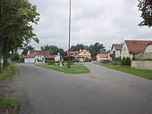
Buzice [ ˈbʊsɪt͡sɛ ] (German Busitz ) is a municipality in the Czech Republic . It is located four kilometers east of Blatná in South Bohemia and belongs to the Okres Strakonice .
geography
Geographical location
Buzice is located in the Blatenská pahorkatina hill country. The village is located on the left bank of the Lomnice at the confluence of the Mračovský potok, Paštický potok and Škvořetický potok. To the north are the Krejčí and Vilímec ponds, to the south the Velký drážský rybník and southwest of the Buzičký rybník. In the north rises the Na Remízku (460 m), northeast the Na Vrších (463 m), in the east the Buzíček (498 m), southeast the Boudovka (512 m) and the Pahorek (531 m), in the south the Křesovec ( 496 m) and the Matčí hora (486 m) and northwest of the Nový háj (472 m). A four-kilometer section of the state road II / 121 leads from Blatná to Buzice; a connection to the further course of the II / 121 at Mirotice has not yet been established.
Community structure
The municipality of Buzice consists of the districts Buzice (Busitz) and Václavov (Wenceslas village ) , the settlement Buzičky (Zbusitz) and the layers Bažantnice, Buzičký Dvůr (Neuhof) , Čermák, Hrad and Zbuzy.
Neighboring communities
Neighboring towns are Skaličany, Újezd u Skaličan and Vahlovice in the north, Dvořetice, Lacina, Václavov and Cermak in the Northeast, Buzičky, Zbuzy, mirec, Stráž, Strážovice and Neradov the east, Lom , Jarotice, Chlum and Pohodnice the southeast, Škvořetice , Pacelice, Bažantnice and Němčice in the south, Hněvkov, Mačkov , Lapač, Jízdárna and Hříbárna in the southwest, Buzičký Dvůr, Sídliště Nad Lomnici, Blatná and Sídliště 2 in the west and Bezdědovice and Paštik in the north-west.
history
The first written mention of Buzice was in 1384 as the seat of the Předota of Buzice. The widespread Vladiken family of Buzický von Buzice acquired various goods scattered around the region over the years. In 1498 Zdeniek Lev von Rosental acquired the Buzice estate from Bušek the Elder. J. von Buzice and gave it to Blatná . The fortress was called desolate in 1527. At the end of the 16th century, the owner of the Blatná estate, Wenzel Rozdrazowsky von Rozdrazow, had the fortress converted into a granary. After Franz Ignaz Rozdrazowsky von Rozdrazow died childless in 1691, the Count Kolowrat -Krakowsky inherited the rule. In 1709 Count Josef Serényi von Kis-Serény acquired the Blatná estate. In 1798 the barons Hildprandt von and zu Ottenhausen became owners of the estate.
In 1837 Busitz consisted of 62 houses with 443 residents. There was an inn and a mill in the village. Off were the monolayer Zbusitz or Buziček (Buzičky) , the Grange Neuhof (Buzičký Dvur) with a sheep, and the rebuilt to granary old castle Hrad or Zbuzy (Fixed Buzice) with a bastion (Bažantnice) . The parish was Blatna . Until the middle of the 19th century, Busitz was always subject to the Blatná rule.
After the abolition of patrimonial formed Buzice / Busitz 1850 with the districts Zbuzy and Václavov a municipality in the district administration and the judicial district Blatná. In the course of the abolition of the Okres Blatná, the community was assigned to the Okres Strakonice in 1960. On January 1, 1974 the incorporation to Blatná took place. Buzice and Václavov broke away from Blatná on January 1st, 1993 and formed the municipality of Buzice.
Community structure
The municipality of Buzice consists of the districts Buzice (Busitz) and Václavov (Wenceslas village ) , the settlement Buzičky (Zbusitz) and the layers Bažantnice, Buzičký Dvůr (Neuhof) , Čermák, Hrad and Zbuzy.
Culture and sights
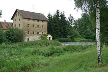
- Fortress Buzice , southwest of Buzice
- Stone bridge over the Lomnice near Buzice. There is a small chapel on the bridge
- Chapel in the village square of Buzice
- Memorial stone for the fallen of the First World War in Buzice
- Chapel in Václavov
Individual evidence
- ↑ Český statistický úřad - The population of the Czech municipalities as of January 1, 2019 (PDF; 0.8 MiB)
- ↑ Johann Gottfried Sommer : The Kingdom of Bohemia. Represented statistically and topographically. Volume 8: Prachiner Circle. Calve, Prague 1840, p. 97.


