
Migré
| Migré | ||
|---|---|---|
|
||
| region | Nouvelle-Aquitaine | |
| Department | Charente-Maritime | |
| Arrondissement | Saint-Jean-d'Angély | |
| Canton | Saint-Jean-d'Angély | |
| Community association | Vals de Saintonge | |
| Coordinates | 46 ° 5 ′ N , 0 ° 33 ′ W | |
| height | 26-88 m | |
| surface | 14.3 km 2 | |
| Residents | 331 (January 1, 2017) | |
| Population density | 23 inhabitants / km 2 | |
| Post Code | 17330 | |
| INSEE code | 17234 | |
| Website | http://www.migre.fr/ | |
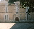
 Town hall (Mairie) of Migré |
||

Migré is a French municipality with 331 inhabitants (as of January 1 2017) in the Charente-Maritime in the region Nouvelle-Aquitaine (before 2016: Poitou-Charentes ); it belongs to the arrondissement of Saint-Jean-d'Angély and is part of the canton of Saint-Jean-d'Angély (until 2015: canton of Loulay ). The inhabitants are called migréens .
geography
Migré is located about 50 kilometers east-southeast of La Rochelle in the Saintonge am Trézence . Migré is surrounded by the neighboring communities of Dœuil-sur-le-Mignon in the north, Villeneuve-la-Comtesse in the north-east, Lusté in the east, Lozay in the south and south-east, Courant in the south and south-west, Bernay-Saint-Martin in the west and south-west as well Saint-Félix to the west and north-west.
Population development
| year | 1962 | 1968 | 1975 | 1982 | 1990 | 1999 | 2006 | 2013 |
| Residents | 479 | 480 | 406 | 338 | 329 | 320 | 333 | 314 |
| Source: Cassini and INSEE | ||||||||
Attractions
- Saint-Benoît church from the 12th century, alterations from the 14th century, bell tower from 1862
- Portal of the former castle of Migré, now integrated into the town hall
- Watermill

Saint-Benoît church
Portal of the former castle


literature
- Le Patrimoine des Communes de la Charente-Maritime. Flohic Editions, Volume 1, Paris 2002, ISBN 2-84234-129-5 , pp. 349-351.